Right-side seats capture the more dramatic geography: the Minnesota River valley and Twin Cities during departure, then the Sierra Madre Oriental mountain chain as it becomes visible during the southbound cruise, and finally the dramatic descent into Mexico City's mountain-ringed basin.
Flown MSP to MEX? Did we get it right?
Flight Path
Minneapolis to Mexico City is 1,790 miles (2,880 km), a flight of about 4 hours.
The flight path crosses central Missouri and northern Arkansas. Notable visible features include the Ozark Plateau (low mountains visible as terrain texture around 1.5 hours into flight), the Mississippi River valley near St. Louis (visible as a distinct corridor), and the transition into the Gulf Coastal Plain. As you approach Mexico, the Sierra Madre Oriental becomes increasingly prominent on the western horizon, and the Trans-Mexican Volcanic Belt becomes visible with peaks like Iztaccíhuatl and Popocatépetl appearing on clear days during the final descent phase.
Great circle distance and headings ›


Phase by phase

Takeoff from MSP
RIGHTMSP typically departs to the south or southeast. Right-side seats offer views of the Minnesota River valley and the urban sprawl of the Twin Cities expanding southward, with clear sightlines toward the initial climb corridor.
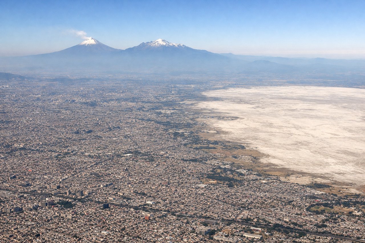
Landing at MEX
LEFTApproaching MEX from the north typically uses runways 5L/5R or 9L/9R. Left-side seats provide excellent views of the Valley of Mexico's geography: the city's northern suburbs, the surrounding mountain rim, and Lake Texcoco's remnants as you descend into the basin.
Will your flight be in sunlight?
Pick a date and time in the Sun Map to watch the sun move across your whole flight.
About This Route
Which side of the plane should I sit on flying from Minneapolis St Paul International (MSP) to Licenciado Benito Juarez International (MEX)?
Sit on the Right side of the plane for the best views on flights from Minneapolis to Mexico City. Right-side seats capture the more dramatic geography: the Minnesota River valley and Twin Cities during departure, then the Sierra Madre Oriental mountain chain as it becomes visible during the southbound cruise, and finally the dramatic descent into Mexico City's mountain-ringed basin.
What can I see during takeoff from Minneapolis St Paul International in Minneapolis?
During takeoff from Minneapolis St Paul International (MSP), sit on the Right side for the best views. MSP typically departs to the south or southeast. Right-side seats offer views of the Minnesota River valley and the urban sprawl of the Twin Cities expanding southward, with clear sightlines toward the initial climb corridor. Notable sights include: Minnesota River valley (immediate south), Mississippi River confluence near Fort Snelling, Twin Cities urban grid (Minneapolis-St. Paul downtown districts visible as a cluster to the southeast), suburban development extending toward Bloomington and Richfield.
What can I see when landing at Licenciado Benito Juarez International in Mexico City?
When landing at Licenciado Benito Juarez International (MEX), sit on the Left side for the best views. Approaching MEX from the north typically uses runways 5L/5R or 9L/9R. Left-side seats provide excellent views of the Valley of Mexico's geography: the city's northern suburbs, the surrounding mountain rim, and Lake Texcoco's remnants as you descend into the basin. Notable sights include: Sierra de Guadalupe mountains (north rim of valley), Lake Texcoco (dried lakebed visible as lighter terrain in the basin), Mexico City's northern suburbs and industrial zones, Popocatépetl volcano (visible on clear days as a distant peak to the southeast on the horizon).
How long is the flight from Minneapolis to Mexico City?
The flight from Minneapolis St Paul International (MSP) to Licenciado Benito Juarez International (MEX) takes about 4 hours. The shortest flight path between them is 1,790 miles (2,880 km); winds and air traffic control usually add a few percent.
What does the Minneapolis to Mexico City flight path pass over?
The flight path crosses central Missouri and northern Arkansas. Notable visible features include the Ozark Plateau (low mountains visible as terrain texture around 1.5 hours into flight), the Mississippi River valley near St. Louis (visible as a distinct corridor), and the transition into the Gulf Coastal Plain. As you approach Mexico, the Sierra Madre Oriental becomes increasingly prominent on the western horizon, and the Trans-Mexican Volcanic Belt becomes visible with peaks like Iztaccíhuatl and Popocatépetl appearing on clear days during the final descent phase.