Atlanta to Harrisburg is 620 miles (997 km), a flight of about 1 hour 55 minutes.
Left side wins at both ends of the flight. During the cruise phase heading northeast, the left side also tracks closer to the Appalachian ridges of Virginia and Maryland, giving you views of the Blue Ridge and Shenandoah Valley terrain that the right side misses.
Flight Path
The flight crosses the Blue Ridge Mountains of northern Georgia and western North Carolina, then the Virginia Appalachians including the Shenandoah Valley and the parallel ridges of the Ridge and Valley province. Over central Virginia and Maryland the terrain flattens into the Piedmont before the final descent into the Susquehanna River valley. The Potomac River valley is visible during the Maryland crossing.
Great circle distance and headings ›Phase by phase
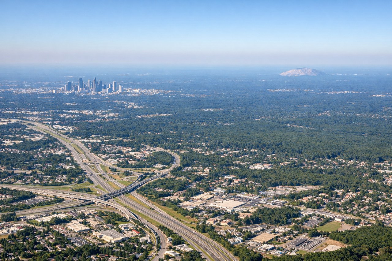
Takeoff from ATL
LEFTATL's primary departure runways (8L/8R heading east, or 10/28 complex) mean a left-side seat gives you a view north over downtown Atlanta's skyline as you climb out. You'll see the dense cluster of Midtown and Downtown towers clearly before the aircraft turns northeast toward the Appalachians.
Landing at MDT
LEFTMDT sits just west of the Susquehanna River, and aircraft typically approach from the southwest on runway 13 or from the south. A left-side seat gives you a clear view of the Susquehanna River's wide braided channel, the Blue Mountain ridge to the north, and the city of Harrisburg itself just before touchdown.
Landmarks on this routeAll landmarks →
Will your flight be in sunlight?
Pick a date and time in the Sun Map to watch the sun move across your whole flight.
About This Route
Which side of the plane should I sit on flying from The William B Hartsfield Atlanta International (ATL) to Harrisburg International (MDT)?
Sit on the Left side of the plane for the best views on flights from Atlanta to Harrisburg. Left side wins at both ends of the flight. During the cruise phase heading northeast, the left side also tracks closer to the Appalachian ridges of Virginia and Maryland, giving you views of the Blue Ridge and Shenandoah Valley terrain that the right side misses.
What can I see during takeoff from The William B Hartsfield Atlanta International in Atlanta?
During takeoff from The William B Hartsfield Atlanta International (ATL), sit on the Left side for the best views. ATL's primary departure runways (8L/8R heading east, or 10/28 complex) mean a left-side seat gives you a view north over downtown Atlanta's skyline as you climb out. You'll see the dense cluster of Midtown and Downtown towers clearly before the aircraft turns northeast toward the Appalachians. Notable sights include: Downtown Atlanta skyline, Stone Mountain (the massive granite dome 16 miles east of downtown), Lake Lanier to the north, Kennesaw Mountain ridge to the northwest.
What can I see when landing at Harrisburg International in Harrisburg?
When landing at Harrisburg International (MDT), sit on the Left side for the best views. MDT sits just west of the Susquehanna River, and aircraft typically approach from the southwest on runway 13 or from the south. A left-side seat gives you a clear view of the Susquehanna River's wide braided channel, the Blue Mountain ridge to the north, and the city of Harrisburg itself just before touchdown. Notable sights include: Susquehanna River (wide and braided through the valley), Blue Mountain ridge (northernmost Appalachian ridge), Harrisburg city center and Pennsylvania State Capitol dome, Three Mile Island (distinctive cooling towers on the river).
How long is the flight from Atlanta to Harrisburg?
The flight from The William B Hartsfield Atlanta International (ATL) to Harrisburg International (MDT) takes about 1 hour 55 minutes. The shortest flight path between them is 620 miles (997 km); winds and air traffic control usually add a few percent.
What does the Atlanta to Harrisburg flight path pass over?
The flight crosses the Blue Ridge Mountains of northern Georgia and western North Carolina, then the Virginia Appalachians including the Shenandoah Valley and the parallel ridges of the Ridge and Valley province. Over central Virginia and Maryland the terrain flattens into the Piedmont before the final descent into the Susquehanna River valley. The Potomac River valley is visible during the Maryland crossing.