The right side strings together Moreton Bay at departure, glimpses of the Coral Sea and Papua New Guinea's coastline during cruise, and a dramatic Pearl River Delta arrival past Hong Kong and Shenzhen. The left side is dominated by inland Queensland scrub and long stretches of open ocean with fewer identifiable landmarks.
Flight Path
Coral Sea, southern coastline of Papua New Guinea near Port Moresby and the Owen Stanley Range, Philippine islands (Mindanao/Palawan area), South China Sea
Great circle distance and headings ›

.jpg?width=600)

Phase by phase
Takeoff from BNE
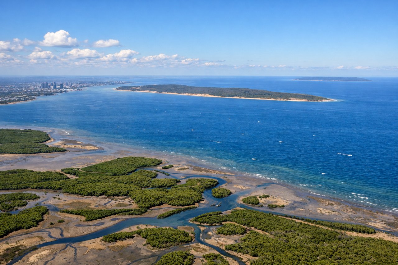
RIGHTDeparting Brisbane, the right side looks out over Moreton Bay with its islands, giving a last clear view of the Queensland coast before the aircraft turns northwest toward open water. The left side faces the flat Lockyer Valley and Great Dividing Range foothills, which are far less distinctive from altitude.
Landing at CAN
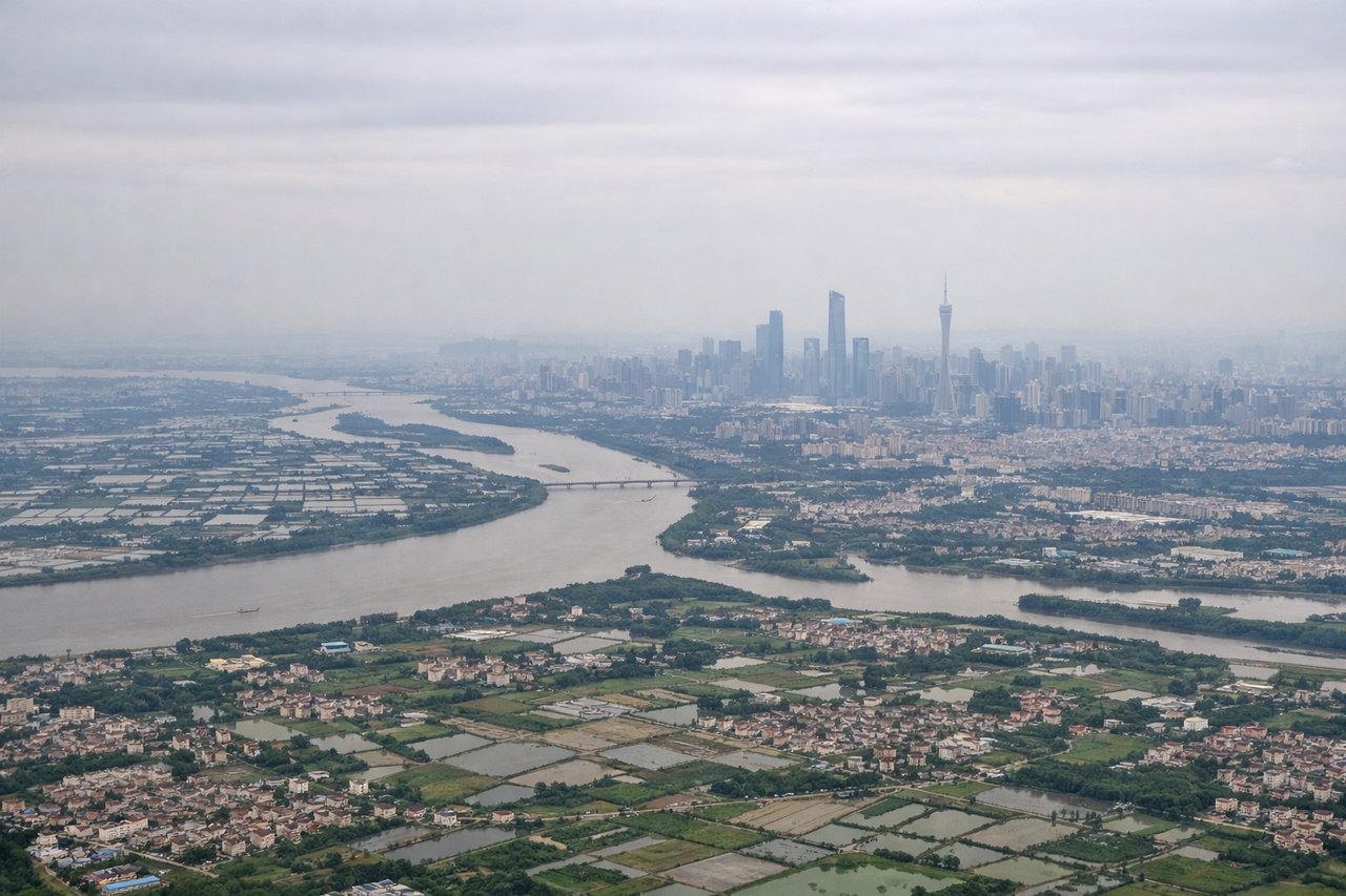
RIGHTOn the descent into Guangzhou, arrivals from the south typically track up the Pearl River Delta, putting Hong Kong and Shenzhen's dense skylines and container port on the right side of the aircraft. The left side instead faces the comparatively quieter Macau and Zhuhai side of the estuary.
Landmarks on this routeAll landmarks →
Will your flight be in sunlight?
See exactly which side of the plane gets sun and shade at your departure time.
About This Route
Which side of the plane should I sit on flying from Brisbane International (BNE) to Guangzhou Baiyun International Airport (CAN)?
Sit on the Right side of the plane for the best views on flights from Brisbane to Guangzhou. The right side strings together Moreton Bay at departure, glimpses of the Coral Sea and Papua New Guinea's coastline during cruise, and a dramatic Pearl River Delta arrival past Hong Kong and Shenzhen. The left side is dominated by inland Queensland scrub and long stretches of open ocean with fewer identifiable landmarks.
What can I see during takeoff from Brisbane International in Brisbane?
During takeoff from Brisbane International (BNE), sit on the Right side for the best views. Departing Brisbane, the right side looks out over Moreton Bay with its islands, giving a last clear view of the Queensland coast before the aircraft turns northwest toward open water. The left side faces the flat Lockyer Valley and Great Dividing Range foothills, which are far less distinctive from altitude. Notable sights include: Moreton Bay, Moreton Island, North Stradbroke Island, Brisbane River mouth.
What can I see when landing at Guangzhou Baiyun International Airport in Guangzhou?
When landing at Guangzhou Baiyun International Airport (CAN), sit on the Right side for the best views. On the descent into Guangzhou, arrivals from the south typically track up the Pearl River Delta, putting Hong Kong and Shenzhen's dense skylines and container port on the right side of the aircraft. The left side instead faces the comparatively quieter Macau and Zhuhai side of the estuary. Notable sights include: Pearl River Delta waterways, Shenzhen skyline, Hong Kong's outlying islands, Guangzhou's high-rise districts near the Pearl River.
How long is the flight from Brisbane to Guangzhou?
The flight from Brisbane International (BNE) to Guangzhou Baiyun International Airport (CAN) takes 9h 35m.
What does the Brisbane to Guangzhou flight path pass over?
Coral Sea, southern coastline of Papua New Guinea near Port Moresby and the Owen Stanley Range, Philippine islands (Mindanao/Palawan area), South China Sea