Doha to Amritsar is 1,473 miles (2,371 km), a flight of about 3 hours 15 minutes.
The left side captures the dramatic Doha West Bay departure over the Persian Gulf, and during the cruise over Pakistan the left side also offers views of the Indus River plains and the edge of the Thar Desert. While the right side has a slight edge on landing approach into Amritsar, the takeoff spectacle and mid-flight geography give the left seat the overall advantage.
Flight Path
The route crosses the Persian Gulf, then tracks northeast over the UAE and Oman border region, crosses into Pakistan over Balochistan's arid plateau, passes over the Sindh plains and the lower Indus River valley, then crosses into the Punjab plains of Pakistan before entering Indian airspace near Lahore and descending into Amritsar. The Indus River is a notable feature visible from altitude as a wide, braided river system cutting through pale desert terrain.
Great circle distance and headings ›
.jpg?width=600)
Phase by phase
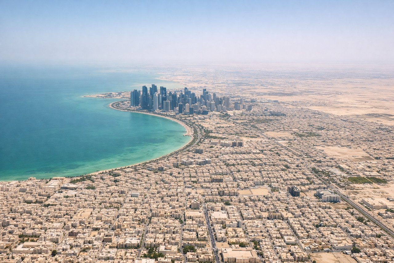
Takeoff from DOH
LEFTDeparting Doha, runways typically head northeast or southwest. A left-side seat gives you views over Doha's West Bay skyline and the inner waters of the Persian Gulf as the aircraft climbs and turns eastward. You'll see the distinctive cluster of towers and the shallow turquoise lagoon clearly.
Landing at ATQ
RIGHTApproaching Amritsar from the southwest, aircraft typically align with runway 11/29 or 03/21. A right-side seat on approach from the west gives views over the flat Punjab agricultural plains and, crucially, the city of Amritsar itself including the Golden Temple complex, which is visible as a glinting structure amid the dense urban grid. The Shivalik foothills are visible to the north on the right side.
Landmarks on this routeAll landmarks →
Will your flight be in sunlight?
Pick a date and time in the Sun Map to watch the sun move across your whole flight.
About This Route
Which side of the plane should I sit on flying from Hamad International Airport (DOH) to Amritsar (ATQ)?
Sit on the Left side of the plane for the best views on flights from Doha to Amritsar. The left side captures the dramatic Doha West Bay departure over the Persian Gulf, and during the cruise over Pakistan the left side also offers views of the Indus River plains and the edge of the Thar Desert. While the right side has a slight edge on landing approach into Amritsar, the takeoff spectacle and mid-flight geography give the left seat the overall advantage.
What can I see during takeoff from Hamad International Airport in Doha?
During takeoff from Hamad International Airport (DOH), sit on the Left side for the best views. Departing Doha, runways typically head northeast or southwest. A left-side seat gives you views over Doha's West Bay skyline and the inner waters of the Persian Gulf as the aircraft climbs and turns eastward. You'll see the distinctive cluster of towers and the shallow turquoise lagoon clearly. Notable sights include: Doha West Bay skyline, Persian Gulf inner lagoon, Palm Tree Island (Al Safliya), Qatar's low desert interior.
What can I see when landing at Amritsar in Amritsar?
When landing at Amritsar (ATQ), sit on the Right side for the best views. Approaching Amritsar from the southwest, aircraft typically align with runway 11/29 or 03/21. A right-side seat on approach from the west gives views over the flat Punjab agricultural plains and, crucially, the city of Amritsar itself including the Golden Temple complex, which is visible as a glinting structure amid the dense urban grid. The Shivalik foothills are visible to the north on the right side. Notable sights include: Golden Temple complex (Harmandir Sahib), Amritsar urban grid, Punjab agricultural plains (wheat and rice fields), Shivalik Hills on the northern horizon.
How long is the flight from Doha to Amritsar?
The flight from Hamad International Airport (DOH) to Amritsar (ATQ) takes about 3 hours 15 minutes. The shortest flight path between them is 1,473 miles (2,371 km); winds and air traffic control usually add a few percent.
What does the Doha to Amritsar flight path pass over?
The route crosses the Persian Gulf, then tracks northeast over the UAE and Oman border region, crosses into Pakistan over Balochistan's arid plateau, passes over the Sindh plains and the lower Indus River valley, then crosses into the Punjab plains of Pakistan before entering Indian airspace near Lahore and descending into Amritsar. The Indus River is a notable feature visible from altitude as a wide, braided river system cutting through pale desert terrain.