The right side wins overall because the Grand Cayman departure view of Seven Mile Beach and the North Sound is genuinely spectacular and unique — that turquoise-over-white-sand palette is hard to beat. The Toronto arrival on the left is excellent but the right side still gets suburban lake views. Passengers who want the best single moment of the flight should sit right for takeoff.
Flown GCM to YYZ? Did we get it right?
Flight Path
Georgetown to Toronto is 1,688 miles (2,716 km), a flight of about 3 hours 30 minutes.
After leaving Cayman airspace the flight tracks north-northeast over open western Caribbean, crossing Cuba's central highlands around Camaguey at cruise altitude where the island's narrow width and patchwork agricultural interior are visible. The flight then crosses the Straits of Florida and enters US airspace over the Florida Keys or southern Florida, tracking north over the Florida peninsula. Over central Florida the flat terrain and lake-dotted landscape of the Orlando area may be visible. The route continues north over Georgia and the Carolinas, crossing the Appalachian ridgelines — the Blue Ridge and then the parallel folded ridges of the Valley and Ridge province — which appear as long parallel dark-green corrugations from altitude. Crossing into Pennsylvania and then New York state, the terrain flattens toward Lake Ontario. The southern shore of Lake Ontario comes into view before the descent into Pearson.
Great circle distance and headings ›


Phase by phase
Takeoff from GCM
RIGHTOwen Roberts runway 08/26 means departures typically head east or west. Northbound departures to YYZ usually involve a left turn out over the North Sound and then tracking north, putting the right side over Grand Cayman's Seven Mile Beach, the western shoreline, and the vivid turquoise shallows of the North Sound. The left side faces inland over the scrubby interior and eastern mangroves.
Landing at YYZ
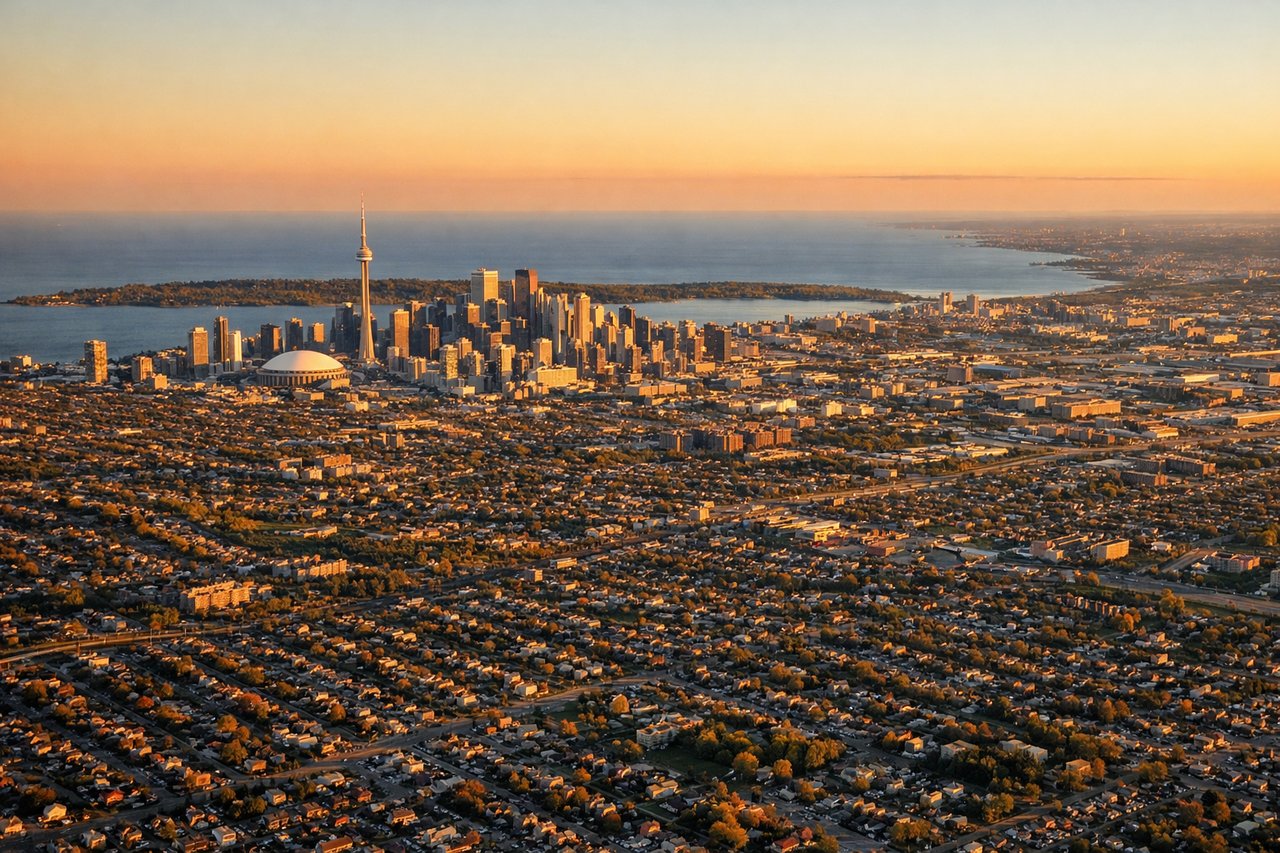
LEFTPearson's most common arrival from the south is runway 05/23 or 06L/24R, with aircraft typically approaching from the southwest over Lake Ontario. On a southerly approach to runways 05 or 06, the left side faces east over downtown Toronto, the CN Tower, and the lake shoreline. The right side looks west over suburban Mississauga with less visual interest.
Will your flight be in sunlight?
Pick a date and time in the Sun Map to watch the sun move across your whole flight.
About This Route
Which side of the plane should I sit on flying from Owen Roberts International (GCM) to Lester B Pearson International (YYZ)?
Sit on the Right side of the plane for the best views on flights from Georgetown to Toronto. The right side wins overall because the Grand Cayman departure view of Seven Mile Beach and the North Sound is genuinely spectacular and unique — that turquoise-over-white-sand palette is hard to beat. The Toronto arrival on the left is excellent but the right side still gets suburban lake views. Passengers who want the best single moment of the flight should sit right for takeoff.
What can I see during takeoff from Owen Roberts International in Georgetown?
During takeoff from Owen Roberts International (GCM), sit on the Right side for the best views. Owen Roberts runway 08/26 means departures typically head east or west. Northbound departures to YYZ usually involve a left turn out over the North Sound and then tracking north, putting the right side over Grand Cayman's Seven Mile Beach, the western shoreline, and the vivid turquoise shallows of the North Sound. The left side faces inland over the scrubby interior and eastern mangroves. Notable sights include: Seven Mile Beach (white sand strip along west coast), North Sound (large shallow lagoon northeast of Georgetown), Grand Cayman western reef line visible as dark blue-to-turquoise color gradient, Georgetown harbor and cruise ship anchorage.
What can I see when landing at Lester B Pearson International in Toronto?
When landing at Lester B Pearson International (YYZ), sit on the Left side for the best views. Pearson's most common arrival from the south is runway 05/23 or 06L/24R, with aircraft typically approaching from the southwest over Lake Ontario. On a southerly approach to runways 05 or 06, the left side faces east over downtown Toronto, the CN Tower, and the lake shoreline. The right side looks west over suburban Mississauga with less visual interest. Notable sights include: CN Tower and downtown Toronto skyline, Lake Ontario shoreline and Toronto Islands, Scarborough Bluffs visible to the east along the lakeshore, Highway 401 corridor as a broad multi-lane ribbon through the suburbs.
How long is the flight from Georgetown to Toronto?
The flight from Owen Roberts International (GCM) to Lester B Pearson International (YYZ) takes about 3 hours 30 minutes. The shortest flight path between them is 1,688 miles (2,716 km); winds and air traffic control usually add a few percent.
What does the Georgetown to Toronto flight path pass over?
After leaving Cayman airspace the flight tracks north-northeast over open western Caribbean, crossing Cuba's central highlands around Camaguey at cruise altitude where the island's narrow width and patchwork agricultural interior are visible. The flight then crosses the Straits of Florida and enters US airspace over the Florida Keys or southern Florida, tracking north over the Florida peninsula. Over central Florida the flat terrain and lake-dotted landscape of the Orlando area may be visible. The route continues north over Georgia and the Carolinas, crossing the Appalachian ridgelines — the Blue Ridge and then the parallel folded ridges of the Valley and Ridge province — which appear as long parallel dark-green corrugations from altitude. Crossing into Pennsylvania and then New York state, the terrain flattens toward Lake Ontario. The southern shore of Lake Ontario comes into view before the descent into Pearson.