The right side delivers the more dramatic takeoff view with KL's skyline and the Titiwangsa Range, and while it misses the best Doha approach views, the departure scenery over Peninsular Malaysia is the highlight of this route. The left side wins at landing but the overall balance tips right for the full journey.
Flown KUL to DOH? Did we get it right?
Flight Path
Kuala Lumpur to Doha is 3,672 miles (5,909 km), a flight of about 7 hours 15 minutes.
The route crosses the Andaman Sea and Bay of Bengal, then tracks over southern India (Tamil Nadu and Kerala coastlines may be visible), crosses the Arabian Sea, passes over the coast of Oman near Muscat, then traverses the Strait of Hormuz and the southern Persian Gulf before descending into Doha. The Bay of Bengal and Arabian Sea dominate the mid-flight view with open ocean. Southern India's Deccan Plateau and Western Ghats ridge may be visible as a distant coastline feature depending on routing.
Great circle distance and headings ›

Phase by phase
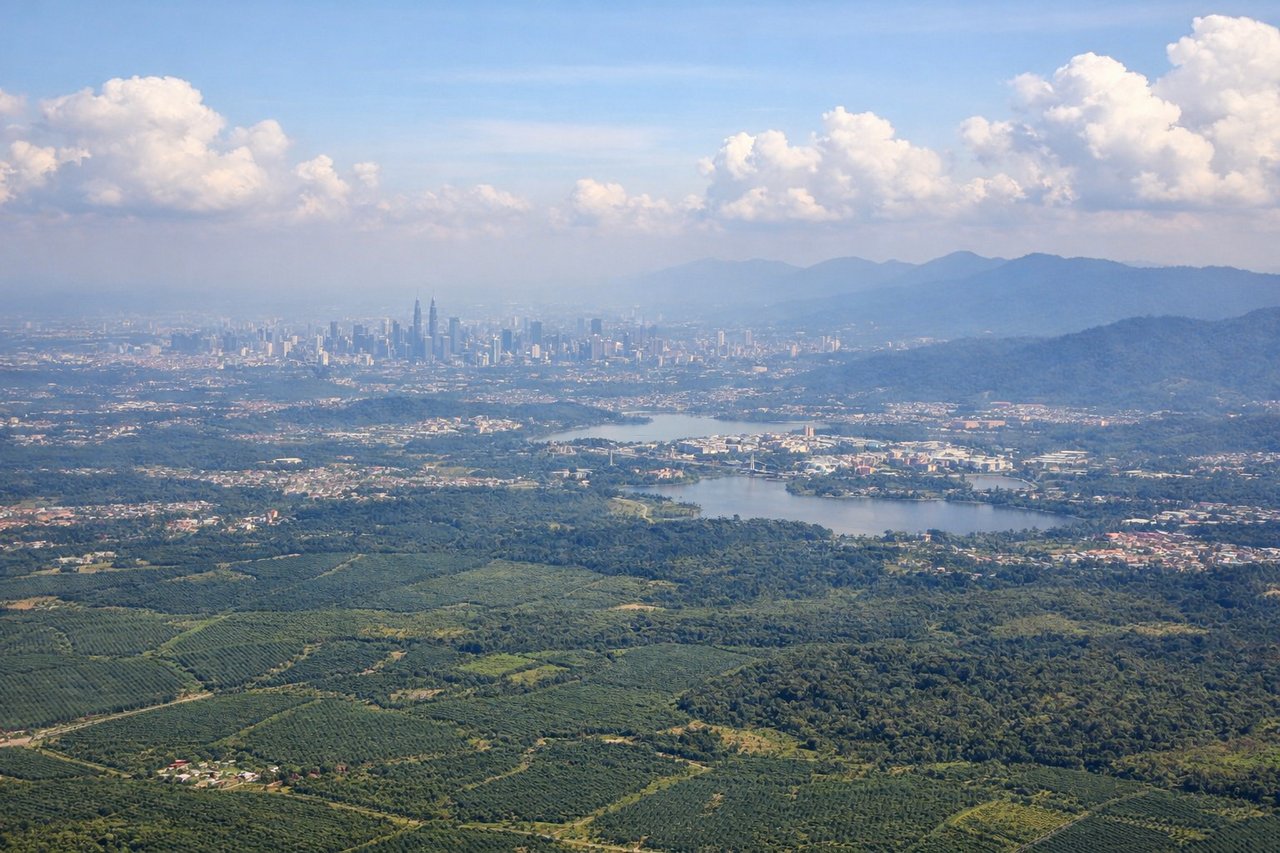
Takeoff from KUL
RIGHTKLIA's runways are oriented roughly north-south. Departures heading northwest toward the Strait of Malacca and then India give the right (east) side a clear view back over Kuala Lumpur city center and the Petronas Towers area as the aircraft banks. The right side also captures the Titiwangsa Range running north-south just east of KL.
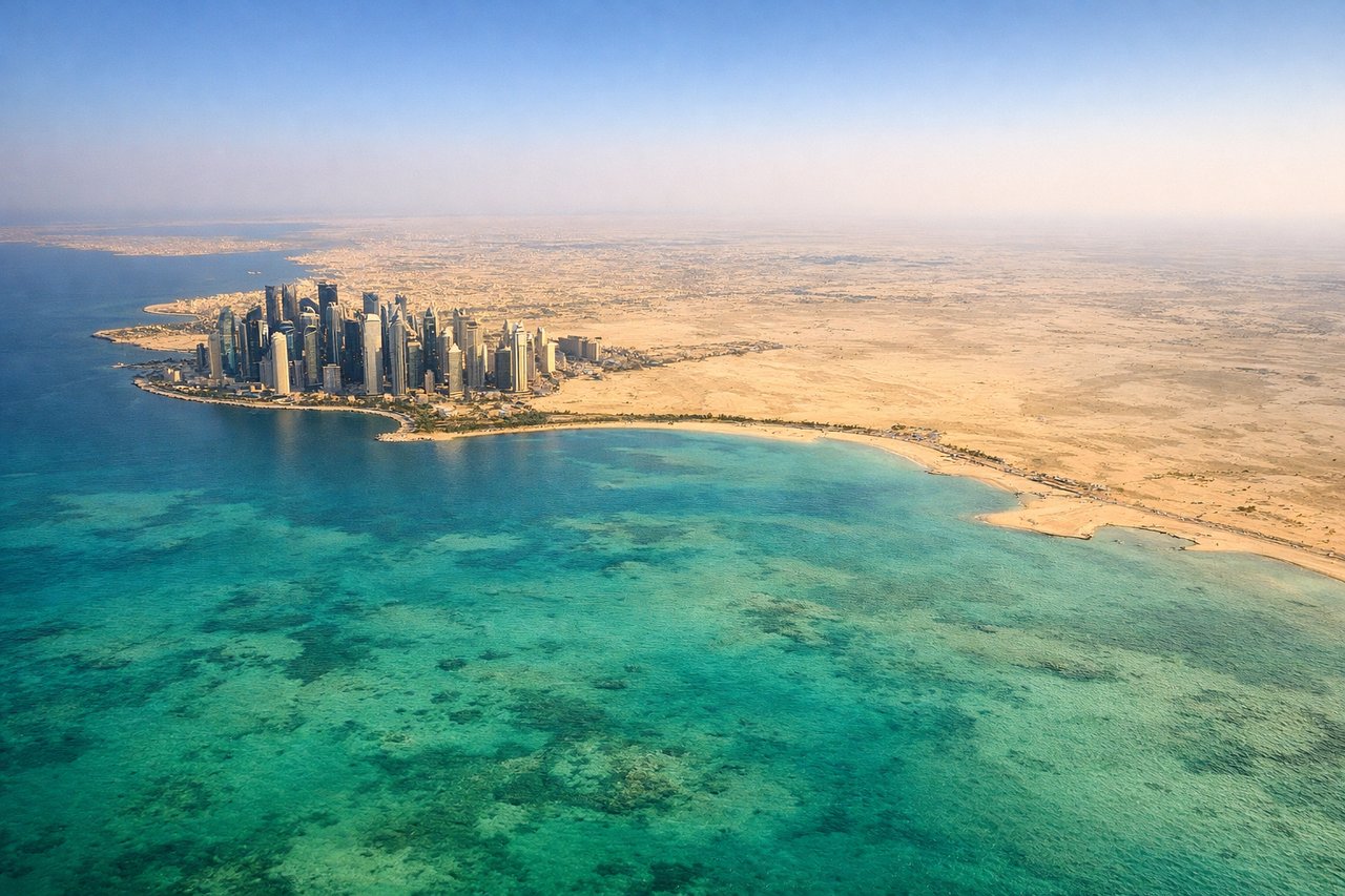
Landing at DOH
LEFTDoha's airport sits on reclaimed land on the eastern shore of Qatar. Approaches from the east or southeast put the left side facing north and west over Doha Bay and the city's distinctive West Bay skyline with its cluster of skyscrapers. The left side also captures the shallow turquoise waters of the Persian Gulf.
Will your flight be in sunlight?
Pick a date and time in the Sun Map to watch the sun move across your whole flight.
About This Route
Which side of the plane should I sit on flying from Kuala Lumpur International (KUL) to Hamad International Airport (DOH)?
Sit on the Right side of the plane for the best views on flights from Kuala Lumpur to Doha. The right side delivers the more dramatic takeoff view with KL's skyline and the Titiwangsa Range, and while it misses the best Doha approach views, the departure scenery over Peninsular Malaysia is the highlight of this route. The left side wins at landing but the overall balance tips right for the full journey.
What can I see during takeoff from Kuala Lumpur International in Kuala Lumpur?
During takeoff from Kuala Lumpur International (KUL), sit on the Right side for the best views. KLIA's runways are oriented roughly north-south. Departures heading northwest toward the Strait of Malacca and then India give the right (east) side a clear view back over Kuala Lumpur city center and the Petronas Towers area as the aircraft banks. The right side also captures the Titiwangsa Range running north-south just east of KL. Notable sights include: Petronas Twin Towers and KL city skyline, Titiwangsa Range (Main Range of Peninsular Malaysia), Klang Valley urban sprawl, Putrajaya federal administrative complex to the south.
What can I see when landing at Hamad International Airport in Doha?
When landing at Hamad International Airport (DOH), sit on the Left side for the best views. Doha's airport sits on reclaimed land on the eastern shore of Qatar. Approaches from the east or southeast put the left side facing north and west over Doha Bay and the city's distinctive West Bay skyline with its cluster of skyscrapers. The left side also captures the shallow turquoise waters of the Persian Gulf. Notable sights include: Doha West Bay skyscraper cluster, Doha Bay and its turquoise shallow waters, The Pearl-Qatar artificial island, Qatar's flat desert interior.
How long is the flight from Kuala Lumpur to Doha?
The flight from Kuala Lumpur International (KUL) to Hamad International Airport (DOH) takes about 7 hours 15 minutes. The shortest flight path between them is 3,672 miles (5,909 km); winds and air traffic control usually add a few percent.
What does the Kuala Lumpur to Doha flight path pass over?
The route crosses the Andaman Sea and Bay of Bengal, then tracks over southern India (Tamil Nadu and Kerala coastlines may be visible), crosses the Arabian Sea, passes over the coast of Oman near Muscat, then traverses the Strait of Hormuz and the southern Persian Gulf before descending into Doha. The Bay of Bengal and Arabian Sea dominate the mid-flight view with open ocean. Southern India's Deccan Plateau and Western Ghats ridge may be visible as a distant coastline feature depending on routing.