Right side wins at both ends of the flight. During the cruise over the Caribbean and Florida Straits the views are largely open water on both sides, so the takeoff and landing phases determine the recommendation, and right side delivers the Blue Mountains on departure and the Miami Beach and Biscayne Bay approach on arrival.
Flight Path
The flight crosses the Caribbean Sea and the Florida Straits, passing north over the western tip of Cuba or just west of it depending on routing. The shallow turquoise waters of the Great Bahama Bank may be visible to the northeast. The Florida Keys appear as a thin curved chain of low islands as you approach the Florida coast, and the Everglades' vast sawgrass marshland is visible on the left side during descent into Miami.
Great circle distance and headings ›Phase by phase
Takeoff from KIN
RIGHTNorman Manley's primary runway (12/30) means northbound departures typically climb out over Kingston Harbour and turn north. The right side gives you the Blue Mountains rising steeply behind Kingston, with peaks over 7,400 feet clearly visible. The left side faces open Caribbean Sea with little of interest.
Landing at MIA
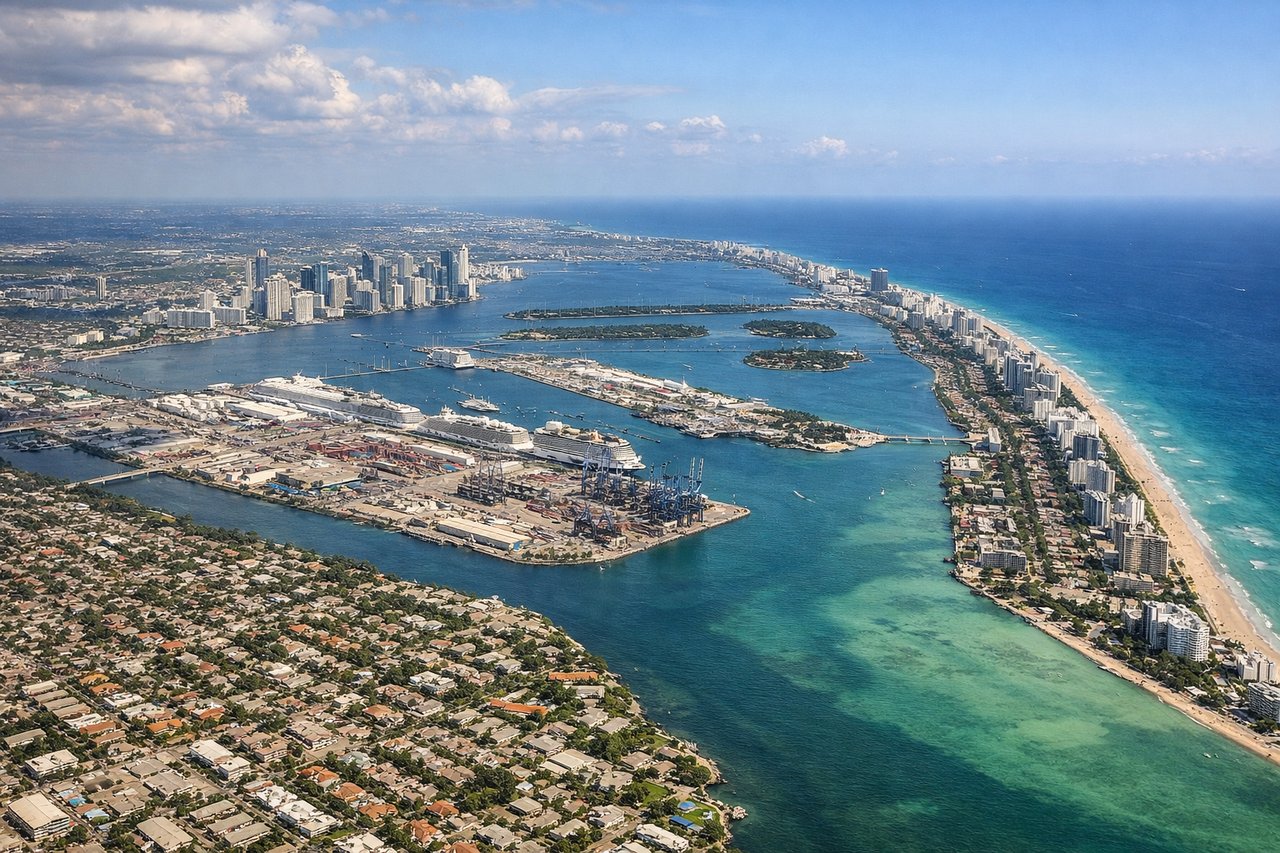
RIGHTMiami International primarily uses runways 08/26 or 09/27 for arrivals from the south, meaning aircraft approach from the south over Biscayne Bay and the Miami Beach barrier island. The right side on approach gives you the Miami Beach coastline, South Beach, and the downtown Miami skyline clearly visible across Biscayne Bay. The left side faces inland Hialeah and suburban sprawl.
Landmarks on this routeAll landmarks →
Will your flight be in sunlight?
See exactly which side of the plane gets sun and shade at your departure time.
About This Route
Which side of the plane should I sit on flying from Norman Manley International (KIN) to Miami International (MIA)?
Sit on the Right side of the plane for the best views on flights from Kingston to Miami. Right side wins at both ends of the flight. During the cruise over the Caribbean and Florida Straits the views are largely open water on both sides, so the takeoff and landing phases determine the recommendation, and right side delivers the Blue Mountains on departure and the Miami Beach and Biscayne Bay approach on arrival.
What can I see during takeoff from Norman Manley International in Kingston?
During takeoff from Norman Manley International (KIN), sit on the Right side for the best views. Norman Manley's primary runway (12/30) means northbound departures typically climb out over Kingston Harbour and turn north. The right side gives you the Blue Mountains rising steeply behind Kingston, with peaks over 7,400 feet clearly visible. The left side faces open Caribbean Sea with little of interest. Notable sights include: Blue Mountains (including Blue Mountain Peak at 7,402 ft), Kingston Harbour, the Palisadoes tombolo strip the airport sits on, Port Royal at the harbour mouth.
What can I see when landing at Miami International in Miami?
When landing at Miami International (MIA), sit on the Right side for the best views. Miami International primarily uses runways 08/26 or 09/27 for arrivals from the south, meaning aircraft approach from the south over Biscayne Bay and the Miami Beach barrier island. The right side on approach gives you the Miami Beach coastline, South Beach, and the downtown Miami skyline clearly visible across Biscayne Bay. The left side faces inland Hialeah and suburban sprawl. Notable sights include: South Beach and Miami Beach barrier island, Biscayne Bay, downtown Miami skyline, Port of Miami on Dodge Island.
How long is the flight from Kingston to Miami?
The flight from Norman Manley International (KIN) to Miami International (MIA) takes Approximately 1 hour 30 minutes.
What does the Kingston to Miami flight path pass over?
The flight crosses the Caribbean Sea and the Florida Straits, passing north over the western tip of Cuba or just west of it depending on routing. The shallow turquoise waters of the Great Bahama Bank may be visible to the northeast. The Florida Keys appear as a thin curved chain of low islands as you approach the Florida coast, and the Everglades' vast sawgrass marshland is visible on the left side during descent into Miami.