While takeoff offers local Columbus interest, the landing approach provides superior scenery: the dramatic San Gabriel Mountains, the vast Los Angeles basin, and Pacific Ocean views make the westbound descent far more visually rewarding for the majority of the flight.
Flown LCK to LAX? Did we get it right?
Flight Path
Columbus to Los Angeles is 1,989 miles (3,201 km), a flight of about 4 hours 15 minutes.
The flight path crosses the Mississippi River near St. Louis, then continues over the Ozark Plateau region of Missouri and Arkansas. Further west, you'll pass over the Texas Panhandle and the High Plains, with the Rocky Mountains (Colorado Front Range) visible to the north around the New Mexico border. The Colorado River and Lake Mead appear as you approach southern Nevada. The Mojave Desert dominates the final approach into Los Angeles.
Great circle distance and headings ›


Phase by phase
Takeoff from LCK
LEFTLeft side captures the Scioto River valley and downtown Columbus skyline during initial climb. You'll see the city grid and surrounding farmland of central Ohio expanding beneath you as you gain altitude.
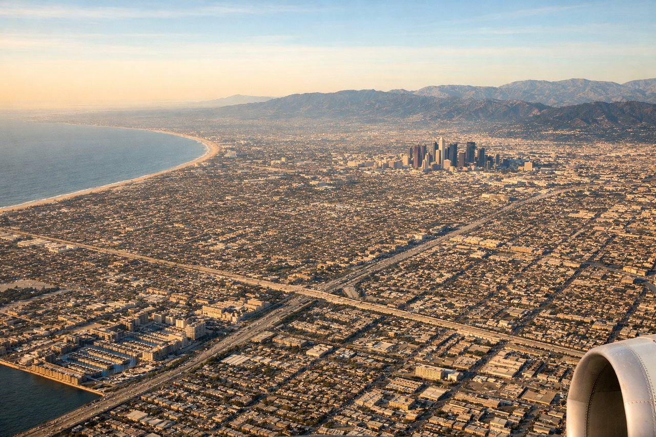
Landing at LAX
RIGHTRight side offers the best views during descent into LAX. You'll see the San Gabriel Mountains rising to the northeast, the Los Angeles basin sprawl, and the Pacific coastline with Santa Monica Bay as you approach from the east.
Will your flight be in sunlight?
Pick a date and time in the Sun Map to watch the sun move across your whole flight.
About This Route
Which side of the plane should I sit on flying from Rickenbacker International (LCK) to Los Angeles International (LAX)?
Sit on the Right side of the plane for the best views on flights from Columbus to Los Angeles. While takeoff offers local Columbus interest, the landing approach provides superior scenery: the dramatic San Gabriel Mountains, the vast Los Angeles basin, and Pacific Ocean views make the westbound descent far more visually rewarding for the majority of the flight.
What can I see during takeoff from Rickenbacker International in Columbus?
During takeoff from Rickenbacker International (LCK), sit on the Left side for the best views. Left side captures the Scioto River valley and downtown Columbus skyline during initial climb. You'll see the city grid and surrounding farmland of central Ohio expanding beneath you as you gain altitude. Notable sights include: Scioto River, downtown Columbus urban core, Ohio farmland grid, Olentangy River confluence.
What can I see when landing at Los Angeles International in Los Angeles?
When landing at Los Angeles International (LAX), sit on the Right side for the best views. Right side offers the best views during descent into LAX. You'll see the San Gabriel Mountains rising to the northeast, the Los Angeles basin sprawl, and the Pacific coastline with Santa Monica Bay as you approach from the east. Notable sights include: San Gabriel Mountains, Los Angeles basin urban grid, Santa Monica Bay, Pacific coastline.
How long is the flight from Columbus to Los Angeles?
The flight from Rickenbacker International (LCK) to Los Angeles International (LAX) takes about 4 hours 15 minutes. The shortest flight path between them is 1,989 miles (3,201 km); winds and air traffic control usually add a few percent.
What does the Columbus to Los Angeles flight path pass over?
The flight path crosses the Mississippi River near St. Louis, then continues over the Ozark Plateau region of Missouri and Arkansas. Further west, you'll pass over the Texas Panhandle and the High Plains, with the Rocky Mountains (Colorado Front Range) visible to the north around the New Mexico border. The Colorado River and Lake Mead appear as you approach southern Nevada. The Mojave Desert dominates the final approach into Los Angeles.