The right side wins on both ends of the flight: a rare close-up of Mexico's iconic volcanoes at departure and a dramatic Wasatch Range approach at arrival, plus glimpses of the Rockies' western edge during cruise, giving it more consistent mountain drama than the desert-and-lake views on the left.
Flown MEX to SLC? Did we get it right?
Flight Path
Mexico City to Salt Lake City is 1,661 miles (2,672 km), a flight of about 4 hours 5 minutes.
Sierra Madre Occidental foothills, Chihuahuan Desert basins, Colorado Plateau red-rock country, southern Rocky Mountain foothills near the Utah-Colorado border
Great circle distance and headings ›


Phase by phase
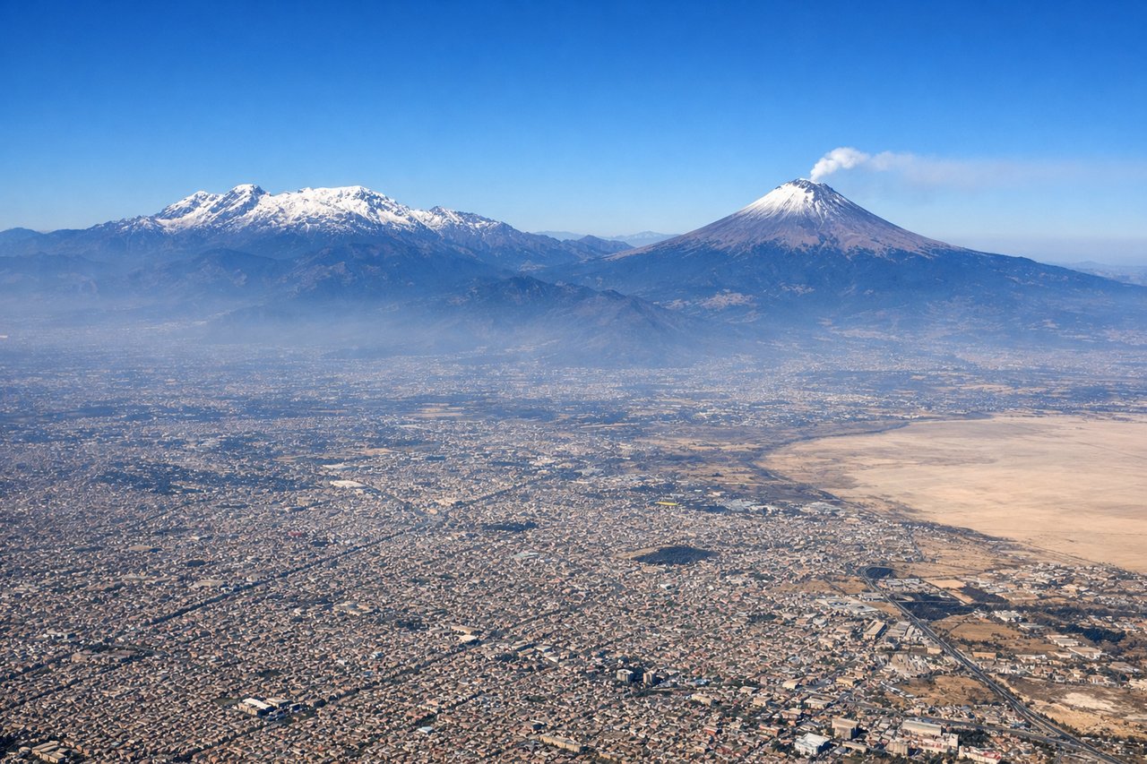
Takeoff from MEX
RIGHTMEX departures typically roll out to the ENE before turning north, putting the volcanic giants southeast of the city on the right side. Popocatepetl and Iztaccihuatl's snow-capped cones rising above the Valley of Mexico are one of the most dramatic departure views in North America.
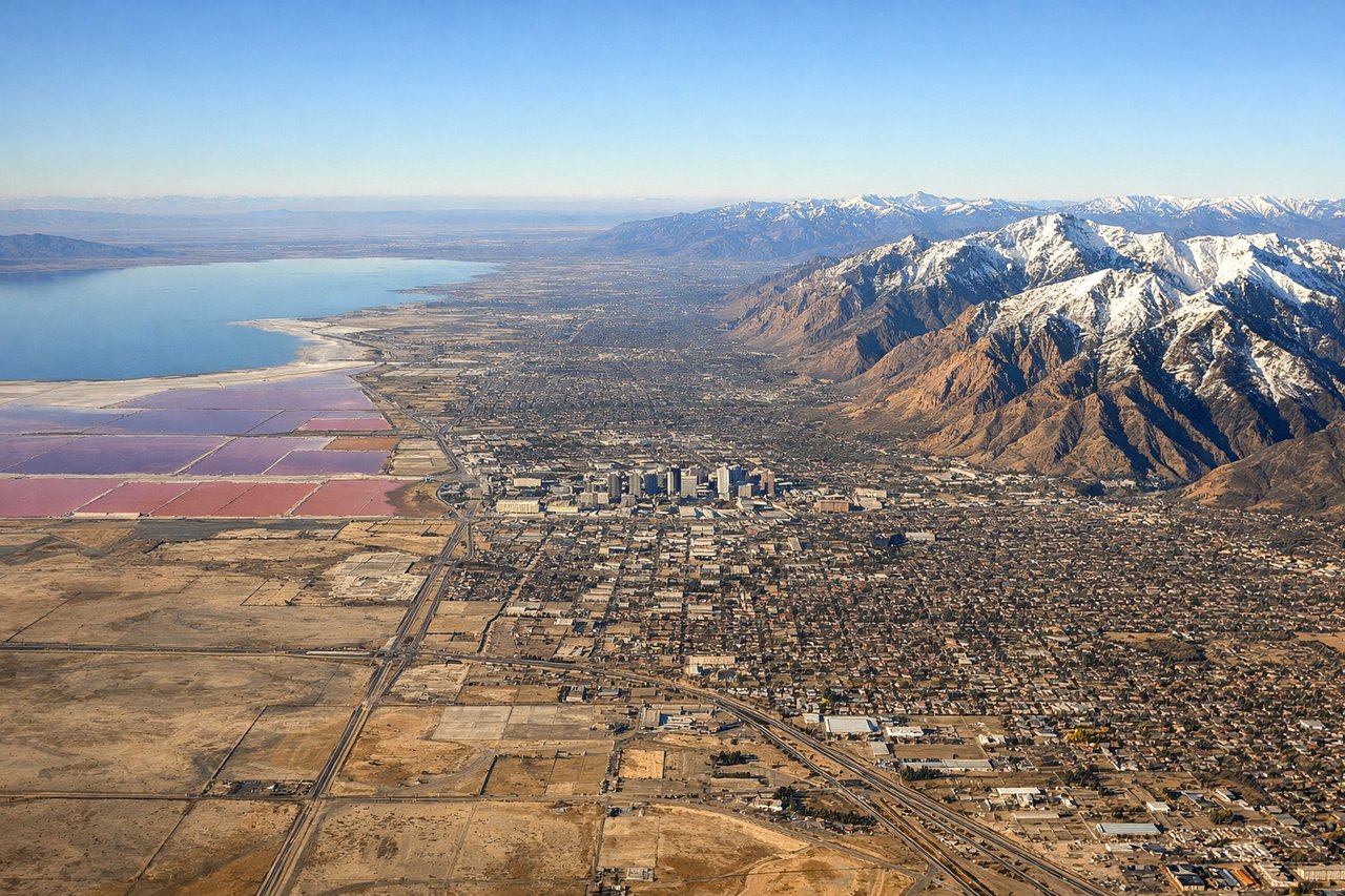
Landing at SLC
RIGHTOn approach into SLC from the south, the Wasatch Range rises abruptly just east of the airport, its steep granite peaks and canyons filling the right-side view as the plane descends over the valley. This is far more dramatic than the flatter lakebed terrain on the left.
Will your flight be in sunlight?
Pick a date and time in the Sun Map to watch the sun move across your whole flight.
About This Route
Which side of the plane should I sit on flying from Licenciado Benito Juarez International (MEX) to Salt Lake City International (SLC)?
Sit on the Right side of the plane for the best views on flights from Mexico City to Salt Lake City. The right side wins on both ends of the flight: a rare close-up of Mexico's iconic volcanoes at departure and a dramatic Wasatch Range approach at arrival, plus glimpses of the Rockies' western edge during cruise, giving it more consistent mountain drama than the desert-and-lake views on the left.
What can I see during takeoff from Licenciado Benito Juarez International in Mexico City?
During takeoff from Licenciado Benito Juarez International (MEX), sit on the Right side for the best views. MEX departures typically roll out to the ENE before turning north, putting the volcanic giants southeast of the city on the right side. Popocatepetl and Iztaccihuatl's snow-capped cones rising above the Valley of Mexico are one of the most dramatic departure views in North America. Notable sights include: Popocatepetl volcano, Iztaccihuatl volcano, Valley of Mexico basin, southern Mexico City sprawl.
What can I see when landing at Salt Lake City International in Salt Lake City?
When landing at Salt Lake City International (SLC), sit on the Right side for the best views. On approach into SLC from the south, the Wasatch Range rises abruptly just east of the airport, its steep granite peaks and canyons filling the right-side view as the plane descends over the valley. This is far more dramatic than the flatter lakebed terrain on the left. Notable sights include: Wasatch Range, Mount Olympus, Salt Lake Valley canyons, Cottonwood Canyon ridgelines.
How long is the flight from Mexico City to Salt Lake City?
The flight from Licenciado Benito Juarez International (MEX) to Salt Lake City International (SLC) takes about 4 hours 5 minutes. The shortest flight path between them is 1,661 miles (2,672 km); winds and air traffic control usually add a few percent.
What does the Mexico City to Salt Lake City flight path pass over?
Sierra Madre Occidental foothills, Chihuahuan Desert basins, Colorado Plateau red-rock country, southern Rocky Mountain foothills near the Utah-Colorado border