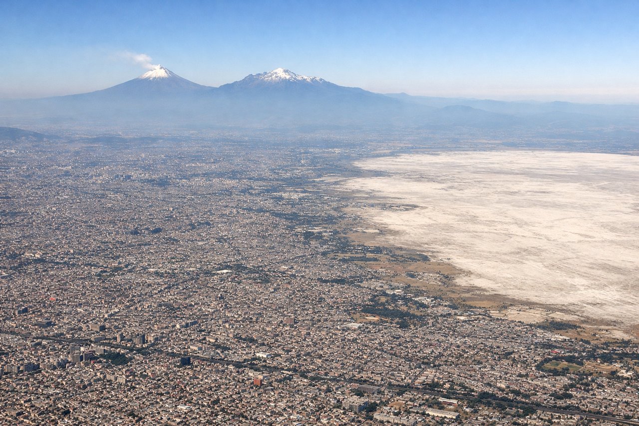
The left side wins primarily on the strength of the approach into Mexico City, where the volcanoes Popocatepetl and Iztaccihuatl dominate the view, a scenic payoff that outweighs the flat, unremarkable terrain seen during takeoff from Merida.
Flown MID to MEX? Did we get it right?
Flight Path
Merida to Mexico City is 620 miles (997 km), a flight of about 1 hour 40 minutes.
Gulf coast lowlands of Campeche and Tabasco, transitioning to the rolling hills and highland plateau of Veracruz and Puebla before entering the Valley of Mexico
Great circle distance and headings ›

Phase by phase
Takeoff from MID
LEFTDeparting MID to the west, both sides show flat Yucatan scrubland and jungle with little relief. The left (south) side has a slight edge later in the climb as the plane angles toward Campeche, hinting at the coastline ahead, but overall this segment is unremarkable on either side.
Landing at MEX
LEFTOn the descent into Mexico City from the east, the approach typically swings over the eastern rim of the Valley of Mexico, putting the snow-capped volcanoes Popocatepetl and Iztaccihuatl on the left side of the aircraft. This is one of the most dramatic landing sequences in Mexico, with the volcanic peaks framing the sprawling city basin below.
Will your flight be in sunlight?
Pick a date and time in the Sun Map to watch the sun move across your whole flight.
About This Route
Which side of the plane should I sit on flying from Licenciado Manuel Crecencio Rejon International (MID) to Licenciado Benito Juarez International (MEX)?
Sit on the Left side of the plane for the best views on flights from Merida to Mexico City. The left side wins primarily on the strength of the approach into Mexico City, where the volcanoes Popocatepetl and Iztaccihuatl dominate the view, a scenic payoff that outweighs the flat, unremarkable terrain seen during takeoff from Merida.
What can I see during takeoff from Licenciado Manuel Crecencio Rejon International in Merida?
During takeoff from Licenciado Manuel Crecencio Rejon International (MID), sit on the Left side for the best views. Departing MID to the west, both sides show flat Yucatan scrubland and jungle with little relief. The left (south) side has a slight edge later in the climb as the plane angles toward Campeche, hinting at the coastline ahead, but overall this segment is unremarkable on either side. Notable sights include: Yucatan flatlands, patchwork of jungle and cleared farmland, Merida's low-rise urban grid receding behind.
What can I see when landing at Licenciado Benito Juarez International in Mexico City?
When landing at Licenciado Benito Juarez International (MEX), sit on the Left side for the best views. On the descent into Mexico City from the east, the approach typically swings over the eastern rim of the Valley of Mexico, putting the snow-capped volcanoes Popocatepetl and Iztaccihuatl on the left side of the aircraft. This is one of the most dramatic landing sequences in Mexico, with the volcanic peaks framing the sprawling city basin below. Notable sights include: Popocatepetl volcano, Iztaccihuatl volcano, eastern edge of the Valley of Mexico, Mexico City's dense urban sprawl.
How long is the flight from Merida to Mexico City?
The flight from Licenciado Manuel Crecencio Rejon International (MID) to Licenciado Benito Juarez International (MEX) takes about 1 hour 40 minutes. The shortest flight path between them is 620 miles (997 km); winds and air traffic control usually add a few percent.
What does the Merida to Mexico City flight path pass over?
Gulf coast lowlands of Campeche and Tabasco, transitioning to the rolling hills and highland plateau of Veracruz and Puebla before entering the Valley of Mexico