The right side offers the more dramatic scenery for the full flight: the Sierra Madre de Oaxaca ridgeline during climb-out and the volcanic peaks of Popocatépetl and Iztaccíhuatl during the descent into Mexico City, while the left side shows mostly flat valley and city grid with less topographic interest.
Flown OAX to MEX? Did we get it right?
Flight Path
Oaxaca to Mexico City is 228 miles (367 km), a flight of about 55 minutes.
Mixteca Alta highlands and the rugged, folded terrain of the Sierra Madre del Sur foothills between Oaxaca and the Valley of Mexico
Great circle distance and headings ›

Phase by phase
Takeoff from OAX
RIGHTOAX sits in a mountain-ringed valley, and departures climbing out typically bank left toward the northwest heading for Mexico City, putting the steep, pine-covered ridgeline of the Sierra Madre de Oaxaca on the right side of the aircraft as it climbs. The left side mostly shows the flatter valley floor and the city of Oaxaca receding quickly.
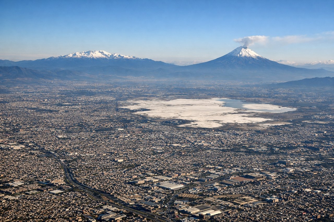
Landing at MEX
RIGHTOn approach into MEX from the south, the flight path curves past the eastern edge of the Valley of Mexico, giving right-side passengers a view of the snow-capped volcanoes Popocatépetl and Iztaccíhuatl before the final turn onto the runway. The left side mostly faces the sprawling western city grid with less distinctive terrain.
Will your flight be in sunlight?
Pick a date and time in the Sun Map to watch the sun move across your whole flight.
About This Route
Which side of the plane should I sit on flying from Xoxocotlan International (OAX) to Licenciado Benito Juarez International (MEX)?
Sit on the Right side of the plane for the best views on flights from Oaxaca to Mexico City. The right side offers the more dramatic scenery for the full flight: the Sierra Madre de Oaxaca ridgeline during climb-out and the volcanic peaks of Popocatépetl and Iztaccíhuatl during the descent into Mexico City, while the left side shows mostly flat valley and city grid with less topographic interest.
What can I see during takeoff from Xoxocotlan International in Oaxaca?
During takeoff from Xoxocotlan International (OAX), sit on the Right side for the best views. OAX sits in a mountain-ringed valley, and departures climbing out typically bank left toward the northwest heading for Mexico City, putting the steep, pine-covered ridgeline of the Sierra Madre de Oaxaca on the right side of the aircraft as it climbs. The left side mostly shows the flatter valley floor and the city of Oaxaca receding quickly. Notable sights include: Sierra Madre de Oaxaca ridgeline, Oaxaca valley floor, Monte Albán archaeological hill (briefly, lower left).
What can I see when landing at Licenciado Benito Juarez International in Mexico City?
When landing at Licenciado Benito Juarez International (MEX), sit on the Right side for the best views. On approach into MEX from the south, the flight path curves past the eastern edge of the Valley of Mexico, giving right-side passengers a view of the snow-capped volcanoes Popocatépetl and Iztaccíhuatl before the final turn onto the runway. The left side mostly faces the sprawling western city grid with less distinctive terrain. Notable sights include: Popocatépetl volcano, Iztaccíhuatl volcano, southeastern edge of the Valley of Mexico, Mexico City's dense urban grid.
How long is the flight from Oaxaca to Mexico City?
The flight from Xoxocotlan International (OAX) to Licenciado Benito Juarez International (MEX) takes about 55 minutes. The shortest flight path between them is 228 miles (367 km); winds and air traffic control usually add a few percent.
What does the Oaxaca to Mexico City flight path pass over?
Mixteca Alta highlands and the rugged, folded terrain of the Sierra Madre del Sur foothills between Oaxaca and the Valley of Mexico