Valparaiso to Windsor Locks is 1,102 miles (1,774 km), a flight of about 3 hours 15 minutes.
While the takeoff offers coastal scenery, the landing approach provides more sustained and dramatic views of major geographic features—the Connecticut River valley and Hartford area are far more visually distinctive than the midpoint flight over the Appalachian plateau and mid-Atlantic interior.
Flight Path
The flight path crosses the Appalachian plateau through Tennessee and Kentucky, with the Cumberland Plateau visible on the left during cruise. The Ohio River valley appears as a darker green corridor running northeast-southwest. The flight then transitions over the Appalachian Mountains of West Virginia and Pennsylvania, with ridge-and-valley topography visible as parallel linear features. As the aircraft approaches the Northeast, the terrain becomes more densely forested with increasing urban sprawl around major cities like Pittsburgh and Philadelphia visible on the left side of the flight path.
Great circle distance and headings ›.jpeg?width=600)
.jpg?width=600)
Phase by phase
Takeoff from VPS
RIGHTRight-side seats offer views of the Choctawhatchee Bay and the Florida Panhandle coastline as the aircraft climbs out northeastward. The contrast between the shallow bay waters and inland pine forests is striking during the initial climb.
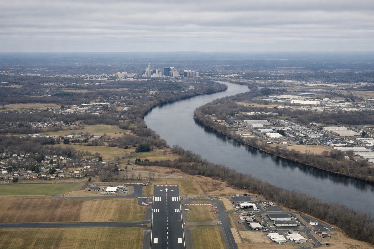
Landing at BDL
LEFTLeft-side seats provide excellent views of the Connecticut River valley and the Hartford metropolitan area during descent into Bradley. The river's distinctive meandering path and the surrounding New England terrain create strong visual landmarks.
Landmarks on this routeAll landmarks →
Will your flight be in sunlight?
Pick a date and time in the Sun Map to watch the sun move across your whole flight.
About This Route
Which side of the plane should I sit on flying from Eglin Afb (VPS) to Bradley International (BDL)?
Sit on the Left side of the plane for the best views on flights from Valparaiso to Windsor Locks. While the takeoff offers coastal scenery, the landing approach provides more sustained and dramatic views of major geographic features—the Connecticut River valley and Hartford area are far more visually distinctive than the midpoint flight over the Appalachian plateau and mid-Atlantic interior.
What can I see during takeoff from Eglin Afb in Valparaiso?
During takeoff from Eglin Afb (VPS), sit on the Right side for the best views. Right-side seats offer views of the Choctawhatchee Bay and the Florida Panhandle coastline as the aircraft climbs out northeastward. The contrast between the shallow bay waters and inland pine forests is striking during the initial climb. Notable sights include: Choctawhatchee Bay, Eglin Air Force Base runways and taxiways, Santa Rosa Sound, Gulf of Mexico horizon.
What can I see when landing at Bradley International in Windsor Locks?
When landing at Bradley International (BDL), sit on the Left side for the best views. Left-side seats provide excellent views of the Connecticut River valley and the Hartford metropolitan area during descent into Bradley. The river's distinctive meandering path and the surrounding New England terrain create strong visual landmarks. Notable sights include: Connecticut River, Hartford skyline, Farmington River confluence, New England deciduous forest patchwork.
How long is the flight from Valparaiso to Windsor Locks?
The flight from Eglin Afb (VPS) to Bradley International (BDL) takes about 3 hours 15 minutes. The shortest flight path between them is 1,102 miles (1,774 km); winds and air traffic control usually add a few percent.
What does the Valparaiso to Windsor Locks flight path pass over?
The flight path crosses the Appalachian plateau through Tennessee and Kentucky, with the Cumberland Plateau visible on the left during cruise. The Ohio River valley appears as a darker green corridor running northeast-southwest. The flight then transitions over the Appalachian Mountains of West Virginia and Pennsylvania, with ridge-and-valley topography visible as parallel linear features. As the aircraft approaches the Northeast, the terrain becomes more densely forested with increasing urban sprawl around major cities like Pittsburgh and Philadelphia visible on the left side of the flight path.