Both sides are dominated by roughly fifteen hours of open ocean over the Tasman Sea, Southern Ocean, and Indian Ocean, so the trip is decided by the bookends: the left side's highland gorge approach into Humera is more sustained and dramatic than the brief harbour glimpse on departure from Auckland.
Flight Path
The great-circle route passes south of mainland Australia through the Southern Ocean, then crosses thousands of kilometers of open Indian Ocean with no land in sight, passing well south of the Cocos Islands and north of the deep Southern Ocean swells before nearing the Seychelles and the East African coast.
Great circle distance and headings ›


Phase by phase
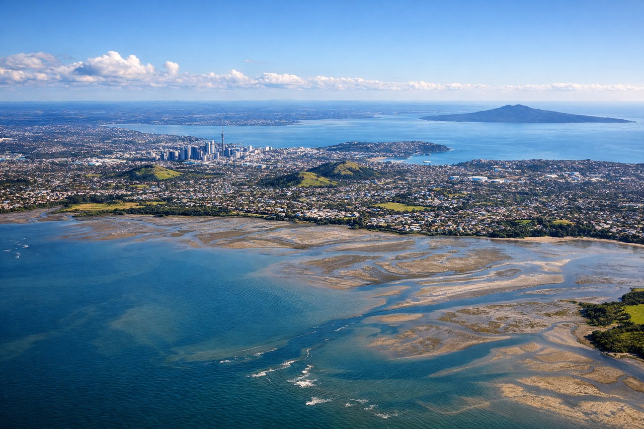
Takeoff from AKL
RIGHTDeparting AKL to the southwest on runway 23L, the right side faces back toward central Auckland, giving a brief but excellent view of the Sky Tower, Waitemata Harbour, and Rangitoto Island's volcanic cone before the coastline gives way to the Tasman Sea.
Landing at HUE
LEFTOn approach into Humera the flight path descends from the Tigray highlands, and the left side faces south across the Tekeze River gorge and the eroded highland escarpment before the terrain flattens into the dry lowland plains near the Sudan border.
Landmarks on this routeAll landmarks →
Will your flight be in sunlight?
See exactly which side of the plane gets sun and shade at your departure time.
About This Route
Which side of the plane should I sit on flying from Auckland International (AKL) to Humera Airport (HUE)?
Sit on the Left side of the plane for the best views on flights from Auckland to Akwi. Both sides are dominated by roughly fifteen hours of open ocean over the Tasman Sea, Southern Ocean, and Indian Ocean, so the trip is decided by the bookends: the left side's highland gorge approach into Humera is more sustained and dramatic than the brief harbour glimpse on departure from Auckland.
What can I see during takeoff from Auckland International in Auckland?
During takeoff from Auckland International (AKL), sit on the Right side for the best views. Departing AKL to the southwest on runway 23L, the right side faces back toward central Auckland, giving a brief but excellent view of the Sky Tower, Waitemata Harbour, and Rangitoto Island's volcanic cone before the coastline gives way to the Tasman Sea. Notable sights include: Auckland Sky Tower, Waitemata Harbour, Rangitoto Island, Manukau Harbour inlets.
What can I see when landing at Humera Airport in Akwi?
When landing at Humera Airport (HUE), sit on the Left side for the best views. On approach into Humera the flight path descends from the Tigray highlands, and the left side faces south across the Tekeze River gorge and the eroded highland escarpment before the terrain flattens into the dry lowland plains near the Sudan border. Notable sights include: Tekeze River gorge, Tigray Plateau escarpment, Simien Mountains foothills (distant), Humera lowland plains.
How long is the flight from Auckland to Akwi?
The flight from Auckland International (AKL) to Humera Airport (HUE) takes 18h 20m.
What does the Auckland to Akwi flight path pass over?
The great-circle route passes south of mainland Australia through the Southern Ocean, then crosses thousands of kilometers of open Indian Ocean with no land in sight, passing well south of the Cocos Islands and north of the deep Southern Ocean swells before nearing the Seychelles and the East African coast.