Left side scores higher due to the exceptional takeoff experience with Mayon Volcano's dramatic volcanic cone and the Albay Gulf coastline, which provides strong visual impact during the critical first 15 minutes of flight. While Hanoi's landing approach offers delta complexity, the takeoff advantage and sustained coastal scenery over the Philippine Sea during cruise outweigh the landing-phase benefits on the right side.
Flown DRP to HAN? Did we get it right?
Flight Path
Legazpi to Hanoi is 1,304 miles (2,099 km), a flight of about 3 hours 10 minutes.
Philippine Sea open water (minimal landmarks), transition from Bicol coastal waters to Vietnamese airspace, occasional views of small Philippine islands (Catanduanes to the east), approach to Vietnamese coast near Thanh Hoa province with Red River delta beginning to appear on descent
Great circle distance and headings ›Phase by phase
Takeoff from DRP
LEFTLeft side captures Mayon Volcano during northeasterly departure from runway 05, a dramatic 2,462 m stratovolcano with distinctive cone shape visible from the airport. The volcano dominates the northern landscape immediately after takeoff, providing iconic Philippine scenery.
Landing at HAN
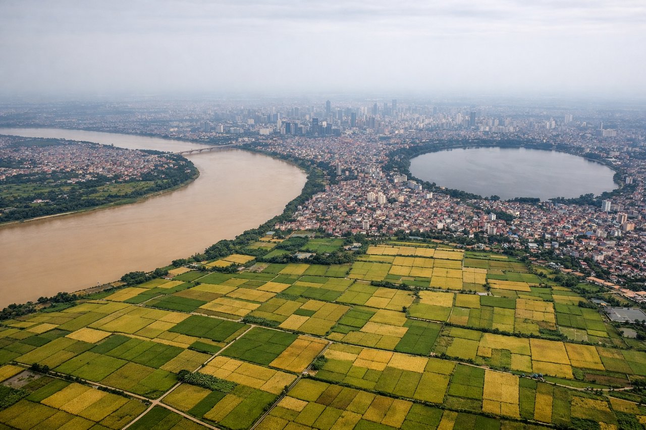
RIGHTRight side (north-facing) during approach to Hanoi offers views of the Red River delta's intricate waterway network and the city's urban sprawl. The delta's braided channels and agricultural patchwork create visual complexity, and the approach typically descends over the delta before turning toward the airport, providing extended scenic views of Vietnam's most densely populated region.
Will your flight be in sunlight?
Pick a date and time in the Sun Map to watch the sun move across your whole flight.
About This Route
Which side of the plane should I sit on flying from Bicol International Airport (DRP) to Noibai International (HAN)?
Sit on the Left side of the plane for the best views on flights from Legazpi to Hanoi. Left side scores higher due to the exceptional takeoff experience with Mayon Volcano's dramatic volcanic cone and the Albay Gulf coastline, which provides strong visual impact during the critical first 15 minutes of flight. While Hanoi's landing approach offers delta complexity, the takeoff advantage and sustained coastal scenery over the Philippine Sea during cruise outweigh the landing-phase benefits on the right side.
What can I see during takeoff from Bicol International Airport in Legazpi?
During takeoff from Bicol International Airport (DRP), sit on the Left side for the best views. Left side captures Mayon Volcano during northeasterly departure from runway 05, a dramatic 2,462 m stratovolcano with distinctive cone shape visible from the airport. The volcano dominates the northern landscape immediately after takeoff, providing iconic Philippine scenery. Notable sights include: Mayon Volcano (northeast of DRP), Albay Gulf coastline, Legazpi city harbor, Cagsawa Ruins area.
What can I see when landing at Noibai International in Hanoi?
When landing at Noibai International (HAN), sit on the Right side for the best views. Right side (north-facing) during approach to Hanoi offers views of the Red River delta's intricate waterway network and the city's urban sprawl. The delta's braided channels and agricultural patchwork create visual complexity, and the approach typically descends over the delta before turning toward the airport, providing extended scenic views of Vietnam's most densely populated region. Notable sights include: Red River delta with braided channels, Hanoi city sprawl and urban districts, Thai Nguyen highlands to the northwest, Noibai Airport approach corridor.
How long is the flight from Legazpi to Hanoi?
The flight from Bicol International Airport (DRP) to Noibai International (HAN) takes about 3 hours 10 minutes. The shortest flight path between them is 1,304 miles (2,099 km); winds and air traffic control usually add a few percent.
What does the Legazpi to Hanoi flight path pass over?
Philippine Sea open water (minimal landmarks), transition from Bicol coastal waters to Vietnamese airspace, occasional views of small Philippine islands (Catanduanes to the east), approach to Vietnamese coast near Thanh Hoa province with Red River delta beginning to appear on descent