While the takeoff offers Cascade views on the left, the landing approach on the right provides more dramatic and varied scenery—Puget Sound, Olympic Mountains, and the Seattle urban landscape create a more memorable visual experience for the majority of passengers.
Flown EAT to SEA? Did we get it right?
Flight Path
Wenatchee to Seattle is 98 miles (158 km), a flight of about 45 minutes.
Snoqualmie Pass area of the Cascades (around 3,000 feet elevation, visible as the lowest crossing point through the range), transition from high desert to forested western slopes, the Cascade foothills with increasing tree coverage, eventual emergence over Puget Sound lowlands with Tacoma visible before final approach to Seattle-Tacoma International
Great circle distance and headings ›Phase by phase
Takeoff from EAT
LEFTLeft side offers immediate views of the Cascade Range as you climb westbound from Wenatchee. The mountains dominate the western horizon and are the primary visual feature during the initial climb-out phase.
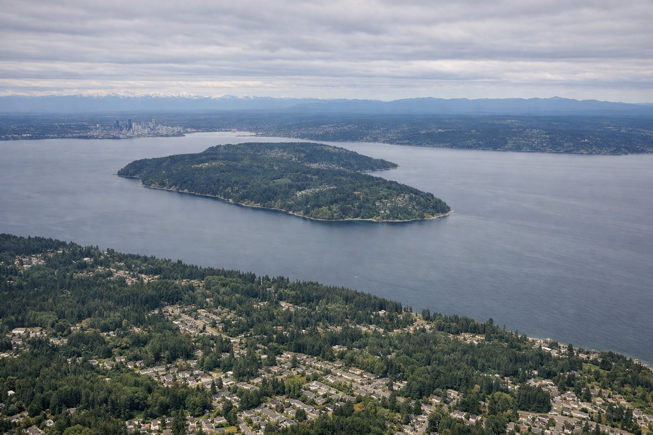
Landing at SEA
RIGHTRight side provides excellent views during descent into Seattle-Tacoma. You'll see Puget Sound, the Olympic Mountains across the water, and the Seattle metropolitan area sprawl before final approach.
Will your flight be in sunlight?
Pick a date and time in the Sun Map to watch the sun move across your whole flight.
About This Route
Which side of the plane should I sit on flying from Pangborn Memorial Airport (EAT) to Seattle Tacoma International (SEA)?
Sit on the Right side of the plane for the best views on flights from Wenatchee to Seattle. While the takeoff offers Cascade views on the left, the landing approach on the right provides more dramatic and varied scenery—Puget Sound, Olympic Mountains, and the Seattle urban landscape create a more memorable visual experience for the majority of passengers.
What can I see during takeoff from Pangborn Memorial Airport in Wenatchee?
During takeoff from Pangborn Memorial Airport (EAT), sit on the Left side for the best views. Left side offers immediate views of the Cascade Range as you climb westbound from Wenatchee. The mountains dominate the western horizon and are the primary visual feature during the initial climb-out phase. Notable sights include: Cascade Range, Columbia River valley floor, Eastern Washington high desert plateau, Wenatchee city grid below.
What can I see when landing at Seattle Tacoma International in Seattle?
When landing at Seattle Tacoma International (SEA), sit on the Right side for the best views. Right side provides excellent views during descent into Seattle-Tacoma. You'll see Puget Sound, the Olympic Mountains across the water, and the Seattle metropolitan area sprawl before final approach. Notable sights include: Puget Sound, Olympic Mountains, Seattle skyline and urban sprawl, Lake Washington.
How long is the flight from Wenatchee to Seattle?
The flight from Pangborn Memorial Airport (EAT) to Seattle Tacoma International (SEA) takes about 45 minutes. The shortest flight path between them is 98 miles (158 km); winds and air traffic control usually add a few percent.
What does the Wenatchee to Seattle flight path pass over?
Snoqualmie Pass area of the Cascades (around 3,000 feet elevation, visible as the lowest crossing point through the range), transition from high desert to forested western slopes, the Cascade foothills with increasing tree coverage, eventual emergence over Puget Sound lowlands with Tacoma visible before final approach to Seattle-Tacoma International