This route offers distinct scenic value on each leg: the right side during departure captures São Paulo's dramatic topography and the Serra da Cantareira, while the left side during arrival showcases Brasília's iconic modernist urban design and Lake Paranoá. Passengers should consider which segment interests them more, or request a seat change mid-flight if possible.
Flight Path
The flight path crosses the interior plateau (Planalto Central) at cruise altitude. Notable features include the Arcanjos Mountain range (visible as a distant ridge around 45 minutes into flight), scattered cerrado vegetation and small towns below, and the gradual transition from São Paulo's humid subtropical landscape to Brasília's drier central plateau. The Parnaíba River basin lies to the east of the direct route. At cruise altitude (around 30,000 feet), individual landmarks become small, but the overall terrain transition from Atlantic Plateau to Central Plateau is geographically significant.
Great circle distance and headings ›Phase by phase

Takeoff from GRU
RIGHTRight-side seats offer views of the Serra da Cantareira mountain range and the urban sprawl of greater São Paulo during the northwestward climb-out. The left side faces the industrial suburbs and lacks significant visual interest.
Landing at BSB
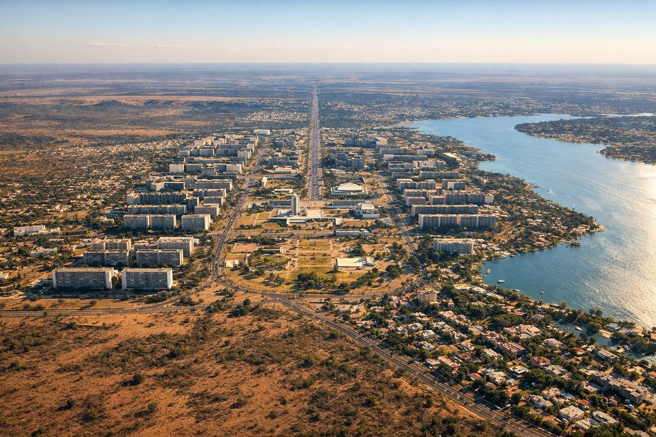
LEFTLeft-side seats provide views of the Brasília Monumental Axis and the city's distinctive modernist urban plan during descent. The right side faces less developed cerrado landscape with minimal visual landmarks.
Landmarks on this routeAll landmarks →
Will your flight be in sunlight?
See exactly which side of the plane gets sun and shade at your departure time.
About This Route
Which side of the plane should I sit on flying from Guarulhos (GRU) to Presidente Juscelino Kubitschek (BSB)?
Sit on the Right for takeoff, Left for landing side of the plane for the best views on flights from Sao Paulo to Brasilia. This route offers distinct scenic value on each leg: the right side during departure captures São Paulo's dramatic topography and the Serra da Cantareira, while the left side during arrival showcases Brasília's iconic modernist urban design and Lake Paranoá. Passengers should consider which segment interests them more, or request a seat change mid-flight if possible.
What can I see during takeoff from Guarulhos in Sao Paulo?
During takeoff from Guarulhos (GRU), sit on the Right side for the best views. Right-side seats offer views of the Serra da Cantareira mountain range and the urban sprawl of greater São Paulo during the northwestward climb-out. The left side faces the industrial suburbs and lacks significant visual interest. Notable sights include: Serra da Cantareira (northern escarpment), Guarulhos urban area, Tietê River valley, Atlantic Plateau edge.
What can I see when landing at Presidente Juscelino Kubitschek in Brasilia?
When landing at Presidente Juscelino Kubitschek (BSB), sit on the Left side for the best views. Left-side seats provide views of the Brasília Monumental Axis and the city's distinctive modernist urban plan during descent. The right side faces less developed cerrado landscape with minimal visual landmarks. Notable sights include: Brasília Monumental Axis (central spine), Lake Paranoá, Plano Piloto urban grid, cerrado grassland.
How long is the flight from Sao Paulo to Brasilia?
The flight from Guarulhos (GRU) to Presidente Juscelino Kubitschek (BSB) takes Approximately 2 hours 15 minutes.
What does the Sao Paulo to Brasilia flight path pass over?
The flight path crosses the interior plateau (Planalto Central) at cruise altitude. Notable features include the Arcanjos Mountain range (visible as a distant ridge around 45 minutes into flight), scattered cerrado vegetation and small towns below, and the gradual transition from São Paulo's humid subtropical landscape to Brasília's drier central plateau. The Parnaíba River basin lies to the east of the direct route. At cruise altitude (around 30,000 feet), individual landmarks become small, but the overall terrain transition from Atlantic Plateau to Central Plateau is geographically significant.