While Hong Kong's takeoff offers superior urban and harbor scenery, the landing approach into Dhaka provides more dramatic geographical contrast and visual variety. The Buriganga River delta's braided channels, the transition from river to dense urban fabric, and the stark flatness of the Bengal plains create more compelling visual storytelling across the full flight. The right side captures both the departure from Hong Kong's mountainous terrain and arrival into Bangladesh's completely flat alluvial landscape—a more geographically significant journey.
Flown HKG to DAC? Did we get it right?
Flight Path
Hong Kong to Dhaka is 1,497 miles (2,409 km), a flight of about 3 hours 15 minutes.
The flight path crosses the Bay of Bengal and the Irrawaddy Delta region of Myanmar. From cruise altitude, the Irrawaddy River's massive delta with its distinctive braided channels and mangrove forests is visible on clear days, marking the transition from the South China Sea toward the Indian subcontinent. The delta's complex network of waterways and islands creates a patchwork pattern visible from 35,000 feet. Beyond Myanmar, the flight enters the flat alluvial plains of Bangladesh, with the Ganges-Brahmaputra delta system becoming visible as the aircraft descends toward Dhaka.
Great circle distance and headings ›Phase by phase
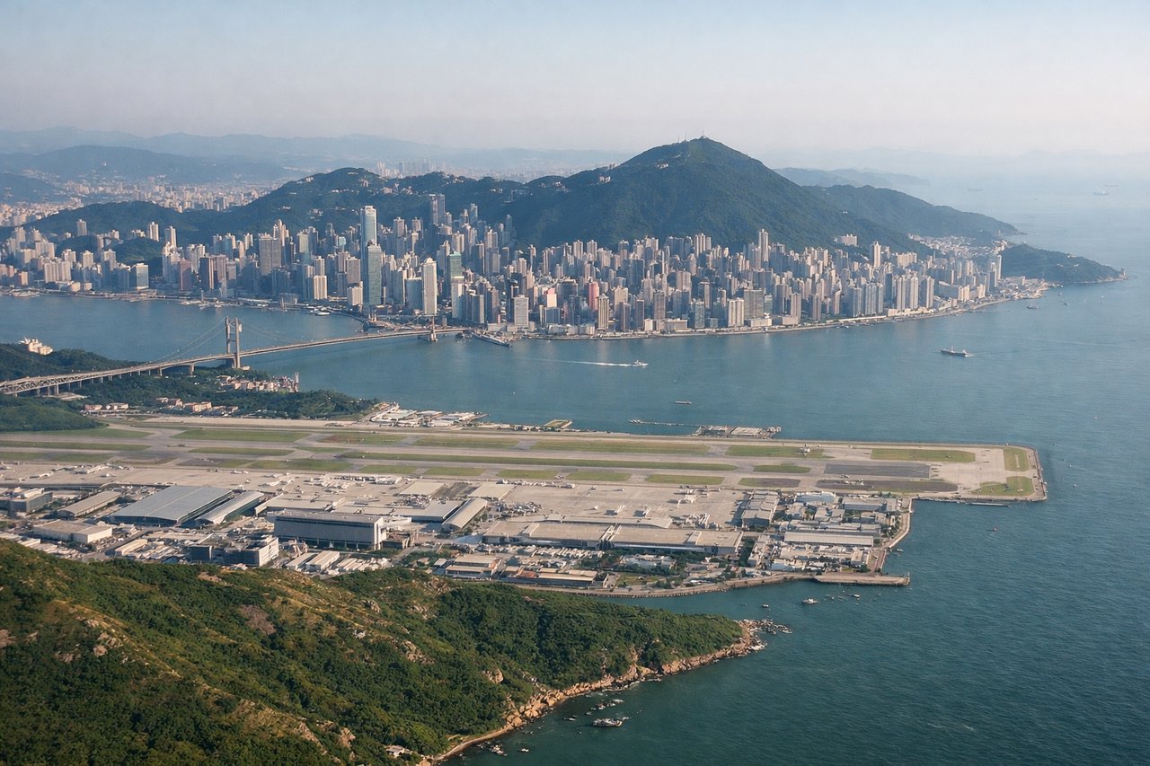
Takeoff from HKG
LEFTHong Kong International Airport sits on Lantau Island with Victoria Harbour and Kowloon Peninsula visible during climb-out. Left seats capture the harbor's dense shipping traffic, the Star Ferry routes, and the urban skyline of Central District and Victoria Peak rising inland.
Landing at DAC
RIGHTZia International Airport's approach crosses the Buriganga River delta and Dhaka's sprawling urban landscape. Right seats offer views of the river's braided channels, the city's dense neighborhoods, and the flat alluvial plains of Bangladesh stretching to the horizon—a dramatic contrast to Hong Kong's vertical terrain.
Will your flight be in sunlight?
Pick a date and time in the Sun Map to watch the sun move across your whole flight.
About This Route
Which side of the plane should I sit on flying from Hong Kong International (HKG) to Hazrat Shahjalal International Airport (DAC)?
Sit on the Right side of the plane for the best views on flights from Hong Kong to Dhaka. While Hong Kong's takeoff offers superior urban and harbor scenery, the landing approach into Dhaka provides more dramatic geographical contrast and visual variety. The Buriganga River delta's braided channels, the transition from river to dense urban fabric, and the stark flatness of the Bengal plains create more compelling visual storytelling across the full flight. The right side captures both the departure from Hong Kong's mountainous terrain and arrival into Bangladesh's completely flat alluvial landscape—a more geographically significant journey.
What can I see during takeoff from Hong Kong International in Hong Kong?
During takeoff from Hong Kong International (HKG), sit on the Left side for the best views. Hong Kong International Airport sits on Lantau Island with Victoria Harbour and Kowloon Peninsula visible during climb-out. Left seats capture the harbor's dense shipping traffic, the Star Ferry routes, and the urban skyline of Central District and Victoria Peak rising inland. Notable sights include: Victoria Harbour with container ships, Kowloon Peninsula skyline, Victoria Peak (1,811 ft), Star Ferry routes crossing the harbor.
What can I see when landing at Hazrat Shahjalal International Airport in Dhaka?
When landing at Hazrat Shahjalal International Airport (DAC), sit on the Right side for the best views. Zia International Airport's approach crosses the Buriganga River delta and Dhaka's sprawling urban landscape. Right seats offer views of the river's braided channels, the city's dense neighborhoods, and the flat alluvial plains of Bangladesh stretching to the horizon—a dramatic contrast to Hong Kong's vertical terrain. Notable sights include: Buriganga River delta with multiple channels, Dhaka's Old City dense urban grid, Sadarghat riverfront district, flat Bengal plains extending to horizon.
How long is the flight from Hong Kong to Dhaka?
The flight from Hong Kong International (HKG) to Hazrat Shahjalal International Airport (DAC) takes about 3 hours 15 minutes. The shortest flight path between them is 1,497 miles (2,409 km); winds and air traffic control usually add a few percent.
What does the Hong Kong to Dhaka flight path pass over?
The flight path crosses the Bay of Bengal and the Irrawaddy Delta region of Myanmar. From cruise altitude, the Irrawaddy River's massive delta with its distinctive braided channels and mangrove forests is visible on clear days, marking the transition from the South China Sea toward the Indian subcontinent. The delta's complex network of waterways and islands creates a patchwork pattern visible from 35,000 feet. Beyond Myanmar, the flight enters the flat alluvial plains of Bangladesh, with the Ganges-Brahmaputra delta system becoming visible as the aircraft descends toward Dhaka.