Both sides get a strong single-phase highlight, but the left side's landing sequence—Mount Rainier paired with the Seattle skyline over Elliott Bay—is more visually striking and lasts longer than the right side's Olympic Mountains view, giving it a slight edge despite the right side's better takeoff.
Flown HNL to SEA? Did we get it right?
Flight Path
Honolulu to Seattle is 2,677 miles (4,308 km), a flight of about 5 hours 45 minutes.
The route crosses roughly 2,600 miles of open North Pacific Ocean with no islands or coastline visible for the bulk of the flight; scenery is essentially featureless water until the Washington coast comes into view near the end of the descent.
Great circle distance and headings ›

Phase by phase
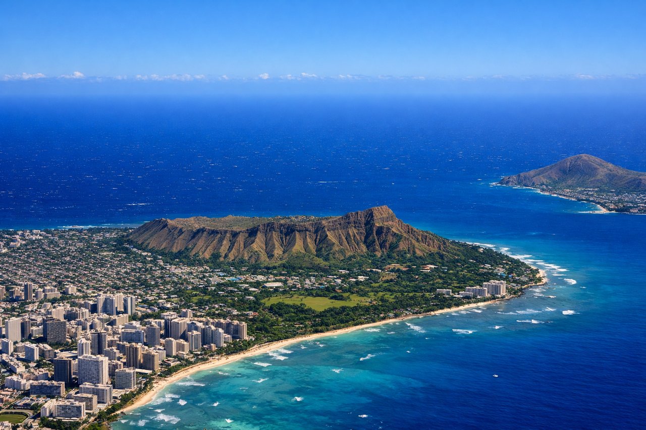
Takeoff from HNL
RIGHTDeparting HNL on the easterly Reef Runway heading, the right side looks south across Waikiki's hotel skyline straight at the Diamond Head crater and the reef-lined south shore. The left side mainly shows the green Ko'olau ridgeline and inland Honolulu, which is nice but less iconic.
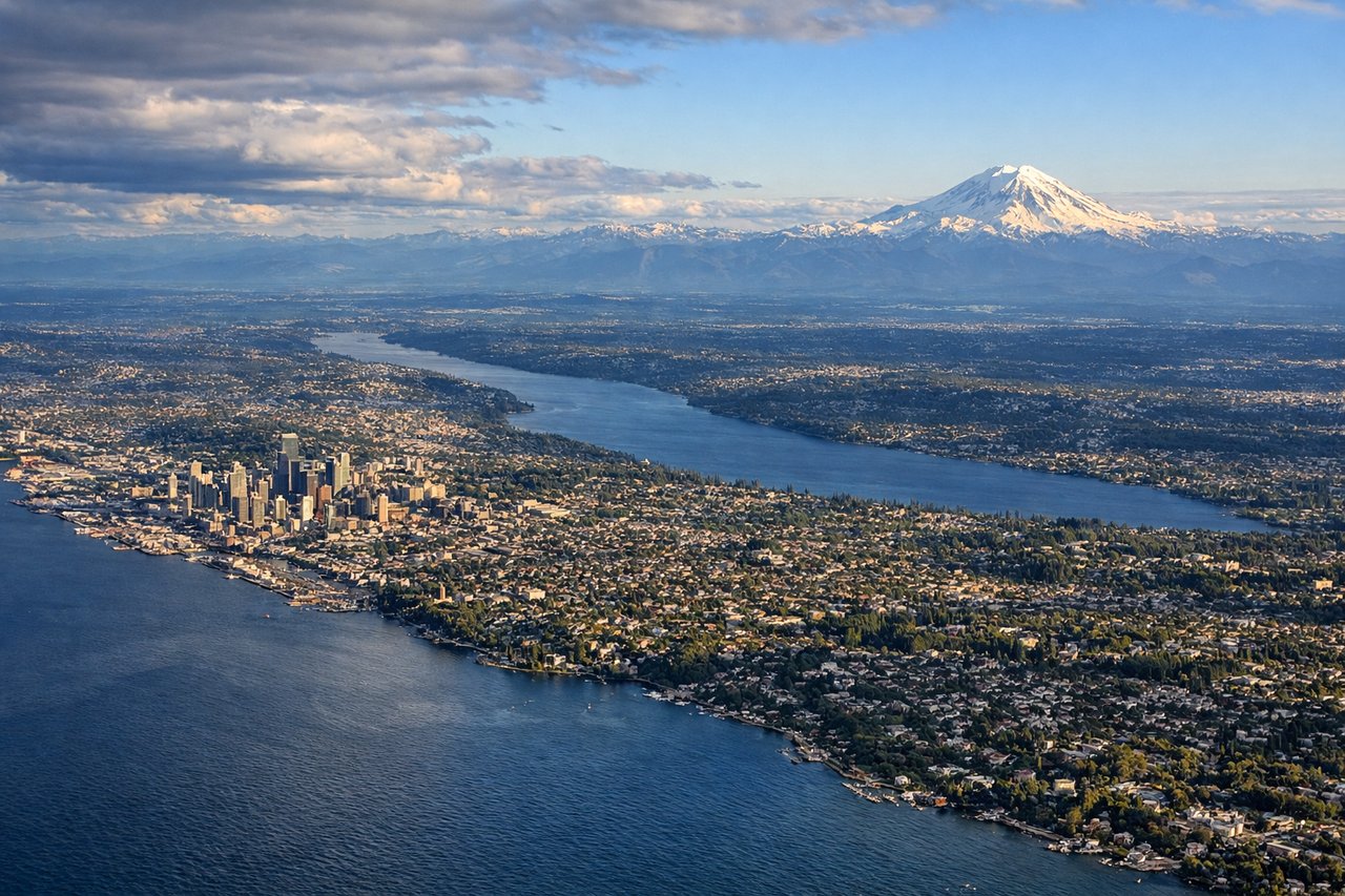
Landing at SEA
LEFTOn the south-heading approach into Sea-Tac, the left side faces east toward the Cascade foothills and Mount Rainier's snow-capped summit, with downtown Seattle and Elliott Bay sliding into view just before touchdown. The right side instead shows the Olympic Mountains and Puget Sound islands, which are scenic but less dramatic than Rainier and the skyline.
Will your flight be in sunlight?
Pick a date and time in the Sun Map to watch the sun move across your whole flight.
About This Route
Which side of the plane should I sit on flying from Honolulu International (HNL) to Seattle Tacoma International (SEA)?
Sit on the Left side of the plane for the best views on flights from Honolulu to Seattle. Both sides get a strong single-phase highlight, but the left side's landing sequence—Mount Rainier paired with the Seattle skyline over Elliott Bay—is more visually striking and lasts longer than the right side's Olympic Mountains view, giving it a slight edge despite the right side's better takeoff.
What can I see during takeoff from Honolulu International in Honolulu?
During takeoff from Honolulu International (HNL), sit on the Right side for the best views. Departing HNL on the easterly Reef Runway heading, the right side looks south across Waikiki's hotel skyline straight at the Diamond Head crater and the reef-lined south shore. The left side mainly shows the green Ko'olau ridgeline and inland Honolulu, which is nice but less iconic. Notable sights include: Diamond Head crater, Waikiki Beach, Honolulu Harbor, Ko'olau Range (opposite side).
What can I see when landing at Seattle Tacoma International in Seattle?
When landing at Seattle Tacoma International (SEA), sit on the Left side for the best views. On the south-heading approach into Sea-Tac, the left side faces east toward the Cascade foothills and Mount Rainier's snow-capped summit, with downtown Seattle and Elliott Bay sliding into view just before touchdown. The right side instead shows the Olympic Mountains and Puget Sound islands, which are scenic but less dramatic than Rainier and the skyline. Notable sights include: Mount Rainier, downtown Seattle skyline, Elliott Bay, Lake Washington.
How long is the flight from Honolulu to Seattle?
The flight from Honolulu International (HNL) to Seattle Tacoma International (SEA) takes about 5 hours 45 minutes. The shortest flight path between them is 2,677 miles (4,308 km); winds and air traffic control usually add a few percent.
What does the Honolulu to Seattle flight path pass over?
The route crosses roughly 2,600 miles of open North Pacific Ocean with no islands or coastline visible for the bulk of the flight; scenery is essentially featureless water until the Washington coast comes into view near the end of the descent.