Washington to Oranjestad is 1,883 miles (3,031 km), a flight of about 3 hours 55 minutes.
The left side captures the only real landmark-rich moments of the flight: the Washington D.C. skyline on departure and Aruba's distinctive coastline and lighthouse on arrival, while the right side spends most of the flight over featureless open ocean.
Flight Path
Extended cruise over the western Atlantic and Bahamas banks, with the shallow turquoise waters of the Great Bahama Bank occasionally visible below before the route continues south over open Caribbean Sea toward Aruba.
Great circle distance and headings ›Phase by phase
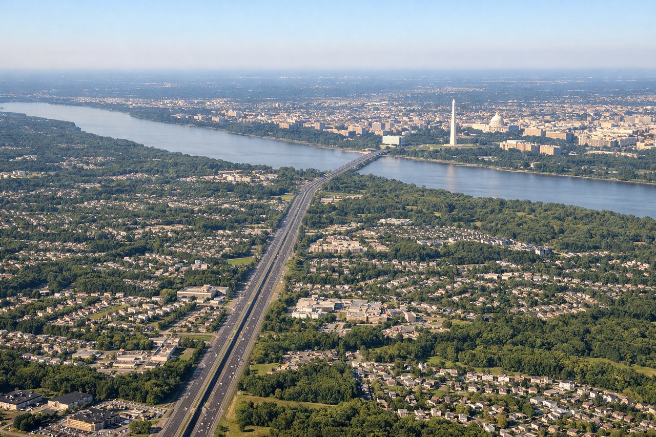
Takeoff from IAD
LEFTDeparting IAD to the south, the initial climb puts Washington D.C.'s monumental core and the Potomac River directly off the left side before the route continues over the Chesapeake Bay region. The right side shows mostly rolling Piedmont countryside with no major landmarks.
Landing at AUA
LEFTOn approach into Aruba, flights typically curve in from the north or northwest before lining up on runway 11, giving left-side passengers a view of the island's rugged northern coastline, the California Lighthouse, and the turquoise shallows fringing Oranjestad. The right side mostly faces open Caribbean Sea.
Will your flight be in sunlight?
Pick a date and time in the Sun Map to watch the sun move across your whole flight.
About This Route
Which side of the plane should I sit on flying from Washington Dulles International (IAD) to Reina Beatrix International (AUA)?
Sit on the Left side of the plane for the best views on flights from Washington to Oranjestad. The left side captures the only real landmark-rich moments of the flight: the Washington D.C. skyline on departure and Aruba's distinctive coastline and lighthouse on arrival, while the right side spends most of the flight over featureless open ocean.
What can I see during takeoff from Washington Dulles International in Washington?
During takeoff from Washington Dulles International (IAD), sit on the Left side for the best views. Departing IAD to the south, the initial climb puts Washington D.C.'s monumental core and the Potomac River directly off the left side before the route continues over the Chesapeake Bay region. The right side shows mostly rolling Piedmont countryside with no major landmarks. Notable sights include: Washington Monument and Capitol dome, Potomac River, Chesapeake Bay shoreline, Northern Virginia suburbs.
What can I see when landing at Reina Beatrix International in Oranjestad?
When landing at Reina Beatrix International (AUA), sit on the Left side for the best views. On approach into Aruba, flights typically curve in from the north or northwest before lining up on runway 11, giving left-side passengers a view of the island's rugged northern coastline, the California Lighthouse, and the turquoise shallows fringing Oranjestad. The right side mostly faces open Caribbean Sea. Notable sights include: Aruba's northern coastline, California Lighthouse, turquoise reef shallows, Oranjestad harbor.
How long is the flight from Washington to Oranjestad?
The flight from Washington Dulles International (IAD) to Reina Beatrix International (AUA) takes about 3 hours 55 minutes. The shortest flight path between them is 1,883 miles (3,031 km); winds and air traffic control usually add a few percent.
What does the Washington to Oranjestad flight path pass over?
Extended cruise over the western Atlantic and Bahamas banks, with the shallow turquoise waters of the Great Bahama Bank occasionally visible below before the route continues south over open Caribbean Sea toward Aruba.