The left side strings together the most memorable moments of the trip: a glimpse of Washington D.C. at departure, the Florida coastline and Caribbean Sea during cruise, and a close-up of the Andes and Bogotá's skyline on arrival, while the right side stays largely over featureless plains and open water.
Flown IAD to BOG? Did we get it right?
Flight Path
Washington to Bogota is 2,375 miles (3,822 km), a flight of about 5 hours 20 minutes.
Crossing the Caribbean Sea south of Cuba/Jamaica, landfall over Colombia's Caribbean coast near the Sierra Nevada de Santa Marta, then south over the Magdalena River valley toward the Eastern Cordillera
Great circle distance and headings ›

Phase by phase
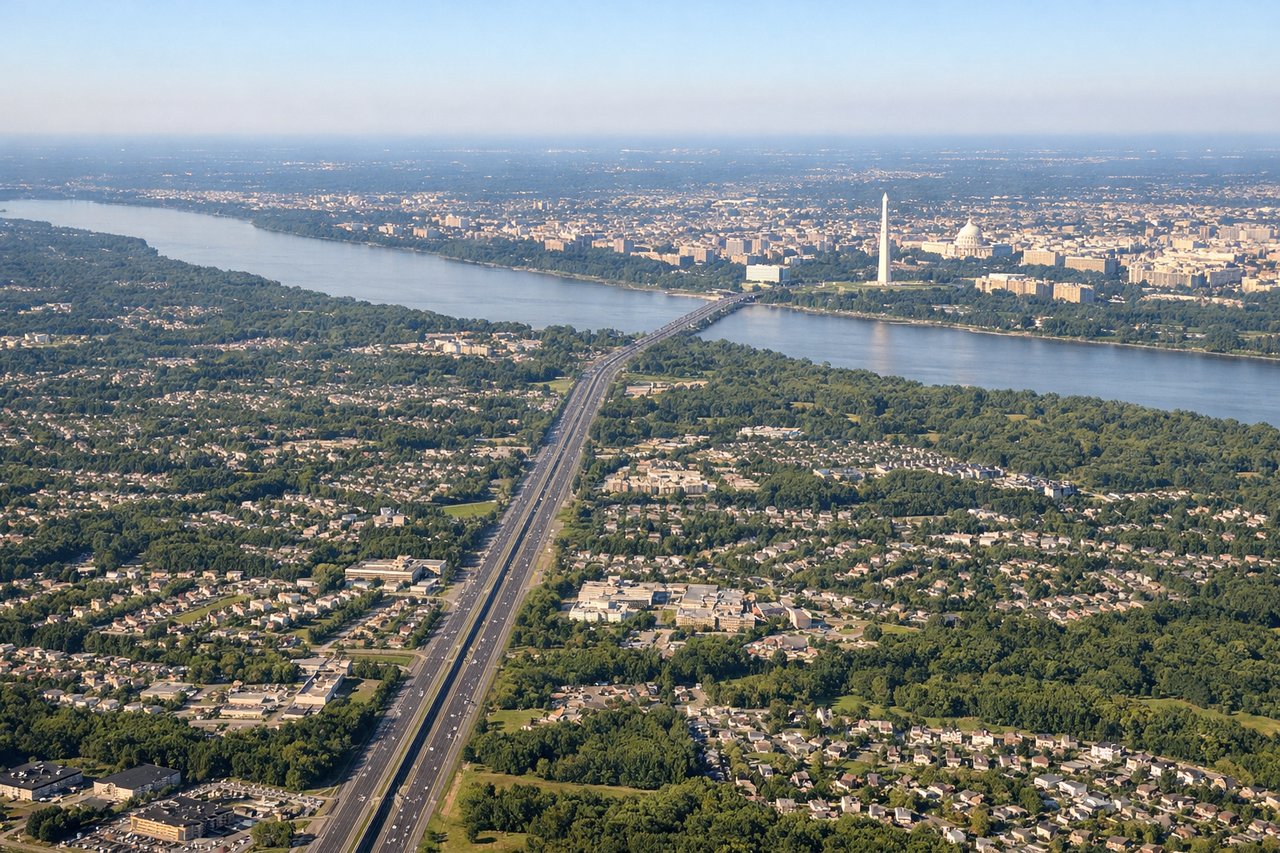
Takeoff from IAD
LEFTDeparting IAD southbound, the left (east-facing) side offers a distant but recognizable view of the Washington D.C. skyline and the Potomac River shortly after climb-out, while the right side only shows the flat, unremarkable Piedmont countryside of northern Virginia.
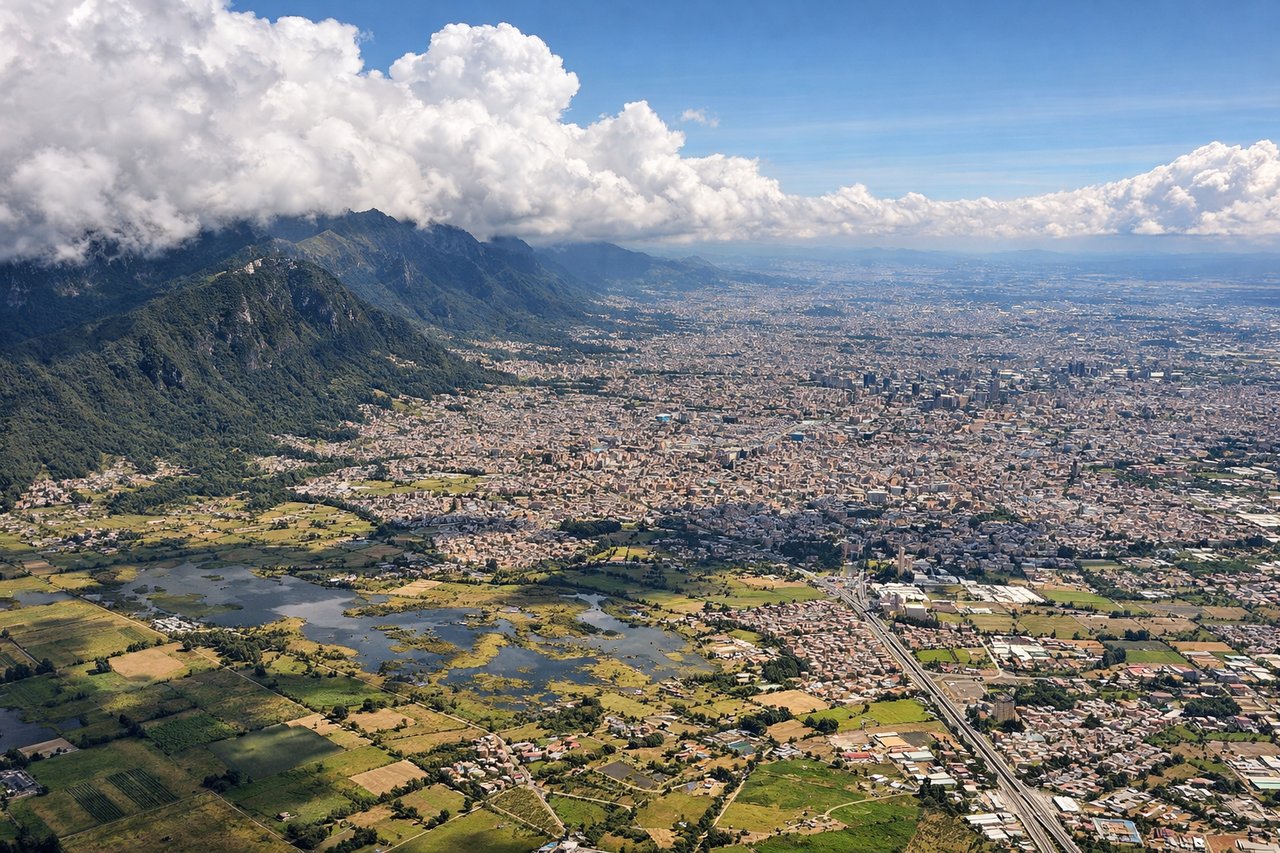
Landing at BOG
LEFTOn approach into El Dorado from the north, the aircraft's left side faces the Eastern Cordillera, giving passengers a close, dramatic view of the Cerros Orientales (Monserrate and Guadalupe) rising directly behind Bogotá as the plane descends onto the high Andean plateau. The right side mostly shows the flatter western edge of the savanna with less defined terrain.
Will your flight be in sunlight?
Pick a date and time in the Sun Map to watch the sun move across your whole flight.
About This Route
Which side of the plane should I sit on flying from Washington Dulles International (IAD) to Eldorado International (BOG)?
Sit on the Left side of the plane for the best views on flights from Washington to Bogota. The left side strings together the most memorable moments of the trip: a glimpse of Washington D.C. at departure, the Florida coastline and Caribbean Sea during cruise, and a close-up of the Andes and Bogotá's skyline on arrival, while the right side stays largely over featureless plains and open water.
What can I see during takeoff from Washington Dulles International in Washington?
During takeoff from Washington Dulles International (IAD), sit on the Left side for the best views. Departing IAD southbound, the left (east-facing) side offers a distant but recognizable view of the Washington D.C. skyline and the Potomac River shortly after climb-out, while the right side only shows the flat, unremarkable Piedmont countryside of northern Virginia. Notable sights include: Washington D.C. skyline (Capitol dome, Washington Monument), the Potomac River, and the Piedmont farmland stretching toward the Chesapeake Bay lowlands.
What can I see when landing at Eldorado International in Bogota?
When landing at Eldorado International (BOG), sit on the Left side for the best views. On approach into El Dorado from the north, the aircraft's left side faces the Eastern Cordillera, giving passengers a close, dramatic view of the Cerros Orientales (Monserrate and Guadalupe) rising directly behind Bogotá as the plane descends onto the high Andean plateau. The right side mostly shows the flatter western edge of the savanna with less defined terrain. Notable sights include: Cerros de Monserrate and Guadalupe, the Sabana de Bogotá plateau, the dense urban sprawl of Bogotá, and the surrounding peaks of the Eastern Cordillera.
How long is the flight from Washington to Bogota?
The flight from Washington Dulles International (IAD) to Eldorado International (BOG) takes about 5 hours 20 minutes. The shortest flight path between them is 2,375 miles (3,822 km); winds and air traffic control usually add a few percent.
What does the Washington to Bogota flight path pass over?
Crossing the Caribbean Sea south of Cuba/Jamaica, landfall over Colombia's Caribbean coast near the Sierra Nevada de Santa Marta, then south over the Magdalena River valley toward the Eastern Cordillera