Left side wins both ends of the flight. During the cruise portion heading south-southeast, the left side also faces east toward the Virginia and North Carolina coastal plain, with occasional glimpses of sounds and river estuaries. It is the consistently better side for the full journey.
Flown IAD to CHS? Did we get it right?
Flight Path
Washington to Charleston is 442 miles (712 km), a flight of about 1 hour 20 minutes.
The flight tracks roughly south-southeast over central Virginia, crossing the James River near Richmond, then over the Roanoke Rapids area of North Carolina, continuing across the flat coastal plain of eastern North Carolina and South Carolina with its extensive river systems including the Roanoke, Neuse, and Pee Dee Rivers, and broad areas of pine forest and agricultural land
Great circle distance and headings ›Phase by phase
Takeoff from IAD
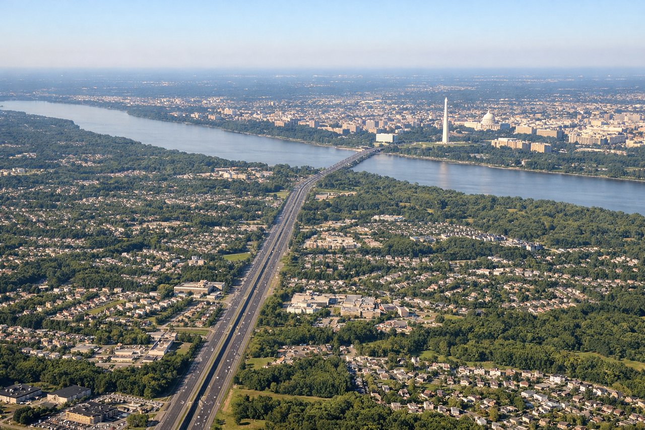
LEFTDulles typically departs east on runway 01R/19L or southeast on 12/30. A left-side seat during an eastward or southeastward departure gives you a clear view back toward the Potomac River, the Washington DC skyline, and the National Mall monuments as the aircraft climbs and turns south. The Capitol dome and Washington Monument are genuinely visible from altitude on this bank.
Landing at CHS
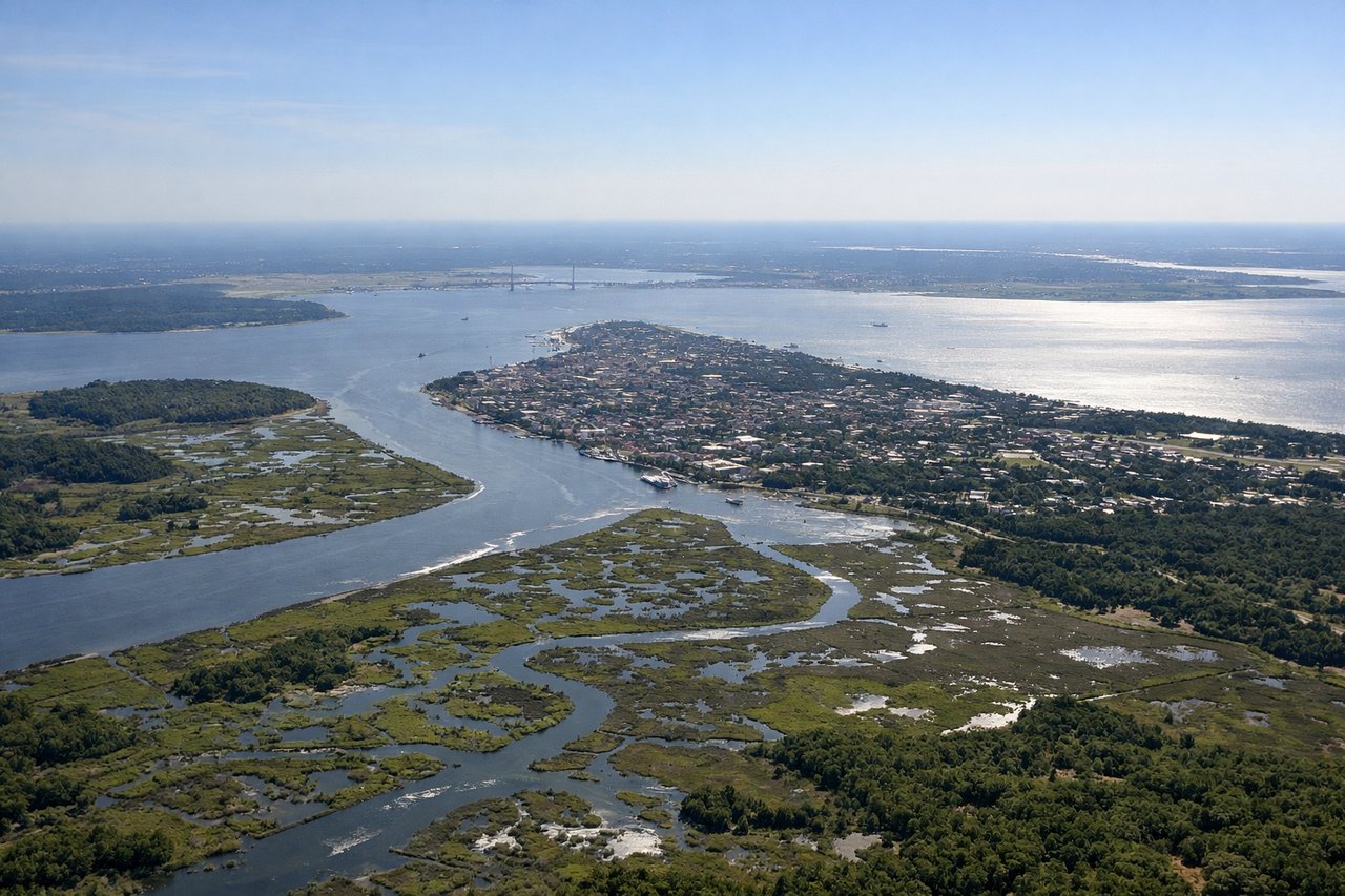
LEFTCharleston typically lands on runway 03/21, with runway 03 being a northward approach from the south. On approach from the north-northwest, a left-side seat faces east toward the Charleston Harbor, the Atlantic coastline, and the barrier islands including Folly Beach and James Island. The harbor and its distinctive peninsula where the Ashley and Cooper Rivers meet are clearly visible on final approach.
Will your flight be in sunlight?
Pick a date and time in the Sun Map to watch the sun move across your whole flight.
About This Route
Which side of the plane should I sit on flying from Washington Dulles International (IAD) to Charleston Afb International (CHS)?
Sit on the Left side of the plane for the best views on flights from Washington to Charleston. Left side wins both ends of the flight. During the cruise portion heading south-southeast, the left side also faces east toward the Virginia and North Carolina coastal plain, with occasional glimpses of sounds and river estuaries. It is the consistently better side for the full journey.
What can I see during takeoff from Washington Dulles International in Washington?
During takeoff from Washington Dulles International (IAD), sit on the Left side for the best views. Dulles typically departs east on runway 01R/19L or southeast on 12/30. A left-side seat during an eastward or southeastward departure gives you a clear view back toward the Potomac River, the Washington DC skyline, and the National Mall monuments as the aircraft climbs and turns south. The Capitol dome and Washington Monument are genuinely visible from altitude on this bank. Notable sights include: Washington DC National Mall and monuments, Potomac River, Tysons Corner urban cluster, Chesapeake Bay in the far distance.
What can I see when landing at Charleston Afb International in Charleston?
When landing at Charleston Afb International (CHS), sit on the Left side for the best views. Charleston typically lands on runway 03/21, with runway 03 being a northward approach from the south. On approach from the north-northwest, a left-side seat faces east toward the Charleston Harbor, the Atlantic coastline, and the barrier islands including Folly Beach and James Island. The harbor and its distinctive peninsula where the Ashley and Cooper Rivers meet are clearly visible on final approach. Notable sights include: Charleston Harbor, Ashley and Cooper River confluence, Charleston historic peninsula, Folly Beach and barrier islands.
How long is the flight from Washington to Charleston?
The flight from Washington Dulles International (IAD) to Charleston Afb International (CHS) takes about 1 hour 20 minutes. The shortest flight path between them is 442 miles (712 km); winds and air traffic control usually add a few percent.
What does the Washington to Charleston flight path pass over?
The flight tracks roughly south-southeast over central Virginia, crossing the James River near Richmond, then over the Roanoke Rapids area of North Carolina, continuing across the flat coastal plain of eastern North Carolina and South Carolina with its extensive river systems including the Roanoke, Neuse, and Pee Dee Rivers, and broad areas of pine forest and agricultural land