While the cruise is almost entirely open Pacific Ocean for both sides, the right side gets the standout moment of the flight: the volcanic, tropical approach into Honolulu with Diamond Head and Waikiki clearly visible, echoing the classic Hawaii-arrival scenery that outshines the more modest Long Beach coastal departure on the left.
Flown LGB to HNL? Did we get it right?
Flight Path
Long Beach to Honolulu is 2,566 miles (4,130 km), a flight of about 5 hours 35 minutes.
The route crosses thousands of miles of open North Pacific Ocean with no islands or landmasses visible until the Hawaiian archipelago appears near the end of the flight; expect only water, cloud formations, and occasional shipping wakes at cruise altitude.
Great circle distance and headings ›

Phase by phase
Takeoff from LGB
LEFTDeparting runway 30, the aircraft banks south toward its oceanic heading, swinging the Long Beach/San Pedro coastline, harbor, and Palos Verdes Peninsula into view on the left side. Catalina Island is often visible as a faint silhouette on the horizon during the climb.
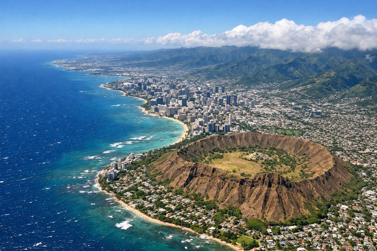
Landing at HNL
RIGHTArrivals into HNL typically curve around the south shore of Oahu before lining up on runway 8L, putting Diamond Head, Waikiki, and downtown Honolulu on the right side of the aircraft during final descent. This is a far more dramatic and memorable view than the open-ocean cruise that dominates the rest of the flight.
Will your flight be in sunlight?
Pick a date and time in the Sun Map to watch the sun move across your whole flight.
About This Route
Which side of the plane should I sit on flying from Long Beach (LGB) to Honolulu International (HNL)?
Sit on the Right side of the plane for the best views on flights from Long Beach to Honolulu. While the cruise is almost entirely open Pacific Ocean for both sides, the right side gets the standout moment of the flight: the volcanic, tropical approach into Honolulu with Diamond Head and Waikiki clearly visible, echoing the classic Hawaii-arrival scenery that outshines the more modest Long Beach coastal departure on the left.
What can I see during takeoff from Long Beach in Long Beach?
During takeoff from Long Beach (LGB), sit on the Left side for the best views. Departing runway 30, the aircraft banks south toward its oceanic heading, swinging the Long Beach/San Pedro coastline, harbor, and Palos Verdes Peninsula into view on the left side. Catalina Island is often visible as a faint silhouette on the horizon during the climb. Notable sights include: Port of Long Beach, Palos Verdes Peninsula, San Pedro Bay, Catalina Island (distant).
What can I see when landing at Honolulu International in Honolulu?
When landing at Honolulu International (HNL), sit on the Right side for the best views. Arrivals into HNL typically curve around the south shore of Oahu before lining up on runway 8L, putting Diamond Head, Waikiki, and downtown Honolulu on the right side of the aircraft during final descent. This is a far more dramatic and memorable view than the open-ocean cruise that dominates the rest of the flight. Notable sights include: Diamond Head crater, Waikiki Beach, Honolulu skyline, Koolau mountain range.
How long is the flight from Long Beach to Honolulu?
The flight from Long Beach (LGB) to Honolulu International (HNL) takes about 5 hours 35 minutes. The shortest flight path between them is 2,566 miles (4,130 km); winds and air traffic control usually add a few percent.
What does the Long Beach to Honolulu flight path pass over?
The route crosses thousands of miles of open North Pacific Ocean with no islands or landmasses visible until the Hawaiian archipelago appears near the end of the flight; expect only water, cloud formations, and occasional shipping wakes at cruise altitude.