San Jose to Honolulu is 2,415 miles (3,886 km), a flight of about 5 hours 35 minutes.
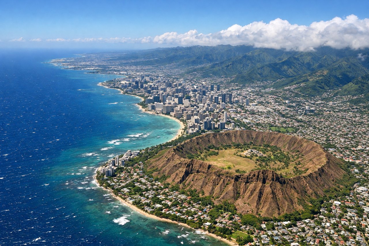
The right side wins on both ends of the flight: a glimpse of San Francisco Bay on departure and the iconic Diamond Head/Waikiki approach into Honolulu, while the long mid-Pacific cruise offers identical open-ocean views from either side.
Flight Path
Open Pacific Ocean with no landmasses visible for several hours between the California coast and the Hawaiian Islands
Great circle distance and headings ›

Phase by phase
Takeoff from SJC
RIGHTDeparting SJC on runway 30, the aircraft climbs northwest over the South Bay before banking left toward the Pacific. During that turn, right-side passengers get a brief but clear view north across San Francisco Bay, including the Dumbarton and San Mateo bridges and the Silicon Valley urban sprawl.
Landing at HNL
RIGHTArrivals into HNL typically approach from the west and land to the east on runway 08, flying directly over south Oahu. On the right (south) side, passengers get a classic descending view of Diamond Head crater, Waikiki's beachfront hotels, and the turquoise reef waters just before touchdown.
Landmarks on this routeAll landmarks →
Will your flight be in sunlight?
Pick a date and time in the Sun Map to watch the sun move across your whole flight.
About This Route
Which side of the plane should I sit on flying from Norman Y Mineta San Jose International (SJC) to Honolulu International (HNL)?
Sit on the Right side of the plane for the best views on flights from San Jose to Honolulu. The right side wins on both ends of the flight: a glimpse of San Francisco Bay on departure and the iconic Diamond Head/Waikiki approach into Honolulu, while the long mid-Pacific cruise offers identical open-ocean views from either side.
What can I see during takeoff from Norman Y Mineta San Jose International in San Jose?
During takeoff from Norman Y Mineta San Jose International (SJC), sit on the Right side for the best views. Departing SJC on runway 30, the aircraft climbs northwest over the South Bay before banking left toward the Pacific. During that turn, right-side passengers get a brief but clear view north across San Francisco Bay, including the Dumbarton and San Mateo bridges and the Silicon Valley urban sprawl. Notable sights include: San Francisco Bay, Dumbarton Bridge, San Mateo Bridge, South Bay cities.
What can I see when landing at Honolulu International in Honolulu?
When landing at Honolulu International (HNL), sit on the Right side for the best views. Arrivals into HNL typically approach from the west and land to the east on runway 08, flying directly over south Oahu. On the right (south) side, passengers get a classic descending view of Diamond Head crater, Waikiki's beachfront hotels, and the turquoise reef waters just before touchdown. Notable sights include: Diamond Head crater, Waikiki Beach, Honolulu skyline, coral reef shallows.
How long is the flight from San Jose to Honolulu?
The flight from Norman Y Mineta San Jose International (SJC) to Honolulu International (HNL) takes about 5 hours 35 minutes. The shortest flight path between them is 2,415 miles (3,886 km); winds and air traffic control usually add a few percent.
What does the San Jose to Honolulu flight path pass over?
Open Pacific Ocean with no landmasses visible for several hours between the California coast and the Hawaiian Islands