The takeoff view of the Wasatch Range is more dramatic and geographically distinctive than the landing approach. However, left-side passengers get the better landing experience. Right-side wins overall because the northern departure climb offers unobstructed, iconic views that are harder to replicate on other routes.
Flown SLC to ONT? Did we get it right?
Flight Path
Salt Lake City to Ontario is 558 miles (898 km), a flight of about 1 hour 15 minutes.
The flight path crosses the Mojave Desert between the two airports. Notable midpoint features include the San Bernardino Mountains (visible to the south during cruise), the Cajon Pass area (where the San Gabriel and San Bernardino ranges converge), and the transition from the high desert around SLC to the lower Inland Empire terrain. The aircraft typically cruises at 25,000-31,000 feet over relatively featureless desert terrain with scattered development around Victorville and Barstow visible to the south.
Great circle distance and headings ›


Phase by phase
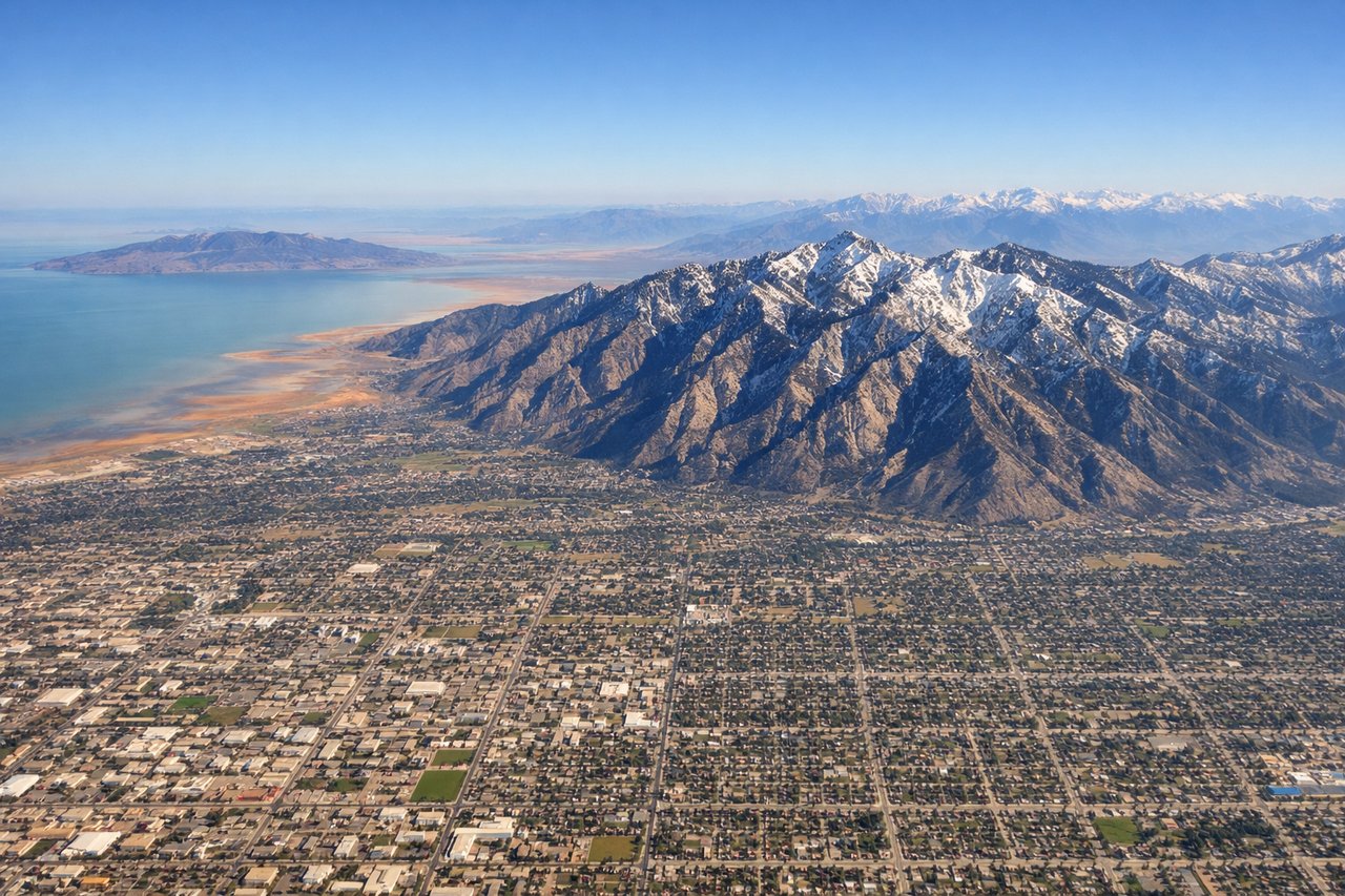
Takeoff from SLC
RIGHTRight-side seats capture the Wasatch Range immediately after departure. SLC typically departs northbound (runways 16L/16R), so right-side passengers get direct views of the dramatic peaks that define Salt Lake City's eastern boundary as the aircraft climbs.
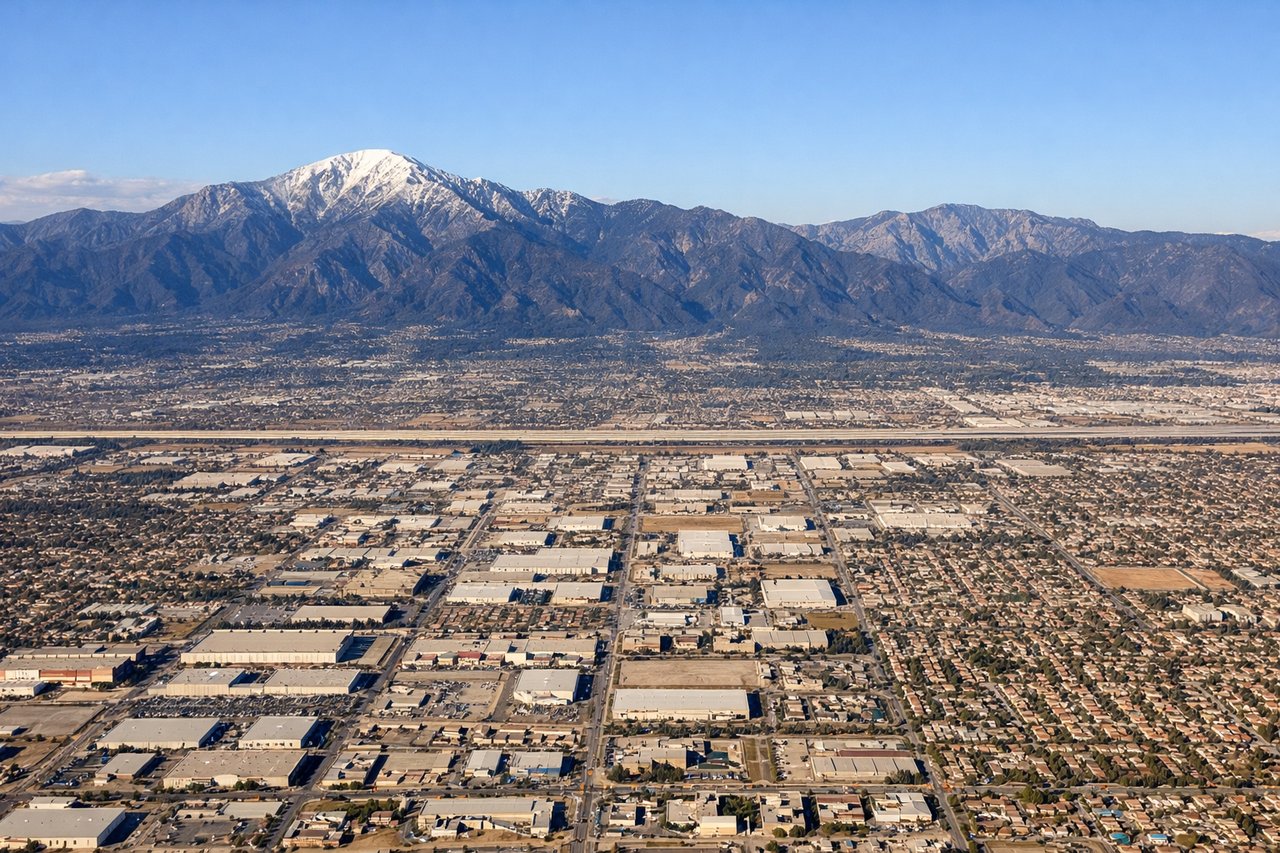
Landing at ONT
LEFTLeft-side seats provide the best views during the final approach into Ontario. Aircraft typically land westbound (runways 26L/26R), so left-side passengers see the San Gabriel Mountains and the Inland Empire's urban sprawl as the aircraft descends toward the airport.
Will your flight be in sunlight?
Pick a date and time in the Sun Map to watch the sun move across your whole flight.
About This Route
Which side of the plane should I sit on flying from Salt Lake City International (SLC) to Ontario International (ONT)?
Sit on the Right side of the plane for the best views on flights from Salt Lake City to Ontario. The takeoff view of the Wasatch Range is more dramatic and geographically distinctive than the landing approach. However, left-side passengers get the better landing experience. Right-side wins overall because the northern departure climb offers unobstructed, iconic views that are harder to replicate on other routes.
What can I see during takeoff from Salt Lake City International in Salt Lake City?
During takeoff from Salt Lake City International (SLC), sit on the Right side for the best views. Right-side seats capture the Wasatch Range immediately after departure. SLC typically departs northbound (runways 16L/16R), so right-side passengers get direct views of the dramatic peaks that define Salt Lake City's eastern boundary as the aircraft climbs. Notable sights include: Wasatch Range (Mount Olympus, Mount Superior visible as distinct peaks), Great Salt Lake (western shore visible as the aircraft banks), Salt Lake Valley floor with grid-pattern urban development, Antelope Island (prominent in the lake's northern section).
What can I see when landing at Ontario International in Ontario?
When landing at Ontario International (ONT), sit on the Left side for the best views. Left-side seats provide the best views during the final approach into Ontario. Aircraft typically land westbound (runways 26L/26R), so left-side passengers see the San Gabriel Mountains and the Inland Empire's urban sprawl as the aircraft descends toward the airport. Notable sights include: San Gabriel Mountains (Mount Baldy and surrounding peaks visible to the north), Inland Empire urban grid (Ontario, Rancho Cucamonga, Fontana visible as dense development), San Bernardino Valley floor, Cajon Pass (visible as the mountain gap to the northeast).
How long is the flight from Salt Lake City to Ontario?
The flight from Salt Lake City International (SLC) to Ontario International (ONT) takes about 1 hour 15 minutes. The shortest flight path between them is 558 miles (898 km); winds and air traffic control usually add a few percent.
What does the Salt Lake City to Ontario flight path pass over?
The flight path crosses the Mojave Desert between the two airports. Notable midpoint features include the San Bernardino Mountains (visible to the south during cruise), the Cajon Pass area (where the San Gabriel and San Bernardino ranges converge), and the transition from the high desert around SLC to the lower Inland Empire terrain. The aircraft typically cruises at 25,000-31,000 feet over relatively featureless desert terrain with scattered development around Victorville and Barstow visible to the south.