Both sides get a modest takeoff and a strong landing, but the right side's landing sequence—Puget Sound, the Olympic Mountains, and the Seattle skyline together—offers more variety and urban interest than the left side's foothills-and-distant-Rainier view, giving it the edge over the full flight.
Flown XLS to SEA? Did we get it right?
Flight Path
St. Louis to Seattle is 6,115 miles (9,841 km), a flight of about 12 hours 10 minutes.
North Atlantic Ocean crossing, the coastline of Atlantic Canada (Nova Scotia/Newfoundland region), the boreal forests and lakes of the Canadian Shield across Quebec, Ontario, Manitoba and Saskatchewan, and the Rocky Mountains/Cascade Range foothills as the route descends into Washington State.
Great circle distance and headings ›

Phase by phase
Takeoff from XLS
LEFTXLS sits right at the mouth of the Senegal River, and departures climbing out before turning northwest toward the Atlantic put the river delta and coastline on the left. The right side only shows flat, featureless Sahel scrubland stretching inland.
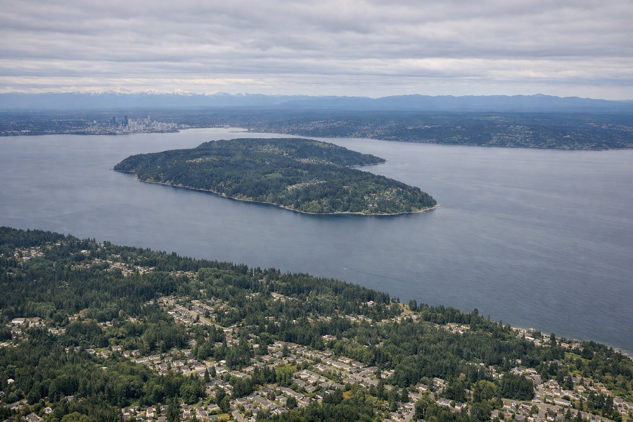
Landing at SEA
RIGHTArriving into SEA from the east, the flight crosses the Cascades before turning to line up on final approach heading south over Puget Sound. The right side captures the Olympic Mountains, the ferries and islands of the Sound, and the downtown Seattle skyline along Elliott Bay, while the left side mainly sees Lake Washington and Cascade foothills with Rainier in the distance.
Will your flight be in sunlight?
Pick a date and time in the Sun Map to watch the sun move across your whole flight.
About This Route
Which side of the plane should I sit on flying from Saint Louis (XLS) to Seattle Tacoma International (SEA)?
Sit on the Right side of the plane for the best views on flights from St. Louis to Seattle. Both sides get a modest takeoff and a strong landing, but the right side's landing sequence—Puget Sound, the Olympic Mountains, and the Seattle skyline together—offers more variety and urban interest than the left side's foothills-and-distant-Rainier view, giving it the edge over the full flight.
What can I see during takeoff from Saint Louis in St. Louis?
During takeoff from Saint Louis (XLS), sit on the Left side for the best views. XLS sits right at the mouth of the Senegal River, and departures climbing out before turning northwest toward the Atlantic put the river delta and coastline on the left. The right side only shows flat, featureless Sahel scrubland stretching inland. Notable sights include: Senegal River delta, Langue de Barbarie sand spit, historic Île de Saint-Louis, Atlantic coastline.
What can I see when landing at Seattle Tacoma International in Seattle?
When landing at Seattle Tacoma International (SEA), sit on the Right side for the best views. Arriving into SEA from the east, the flight crosses the Cascades before turning to line up on final approach heading south over Puget Sound. The right side captures the Olympic Mountains, the ferries and islands of the Sound, and the downtown Seattle skyline along Elliott Bay, while the left side mainly sees Lake Washington and Cascade foothills with Rainier in the distance. Notable sights include: Puget Sound, Olympic Mountains, downtown Seattle skyline and Elliott Bay, Bainbridge/Vashon Islands.
How long is the flight from St. Louis to Seattle?
The flight from Saint Louis (XLS) to Seattle Tacoma International (SEA) takes about 12 hours 10 minutes. The shortest flight path between them is 6,115 miles (9,841 km); winds and air traffic control usually add a few percent.
What does the St. Louis to Seattle flight path pass over?
North Atlantic Ocean crossing, the coastline of Atlantic Canada (Nova Scotia/Newfoundland region), the boreal forests and lakes of the Canadian Shield across Quebec, Ontario, Manitoba and Saskatchewan, and the Rocky Mountains/Cascade Range foothills as the route descends into Washington State.