The right side wins overall due to the spectacular Toronto departure view with the CN Tower and Lake Ontario. The landing view on the left is compelling but the takeoff moment is more dramatic and memorable. During cruise, both sides offer similar boreal forest and Quebec lake district scenery, so the takeoff experience tips the balance to the right.
Flown YYZ to YDF? Did we get it right?
Flight Path
Toronto to Deer Lake is 1,120 miles (1,803 km), a flight of about 2 hours 25 minutes.
The flight tracks northeast over the Canadian Shield of Ontario, crossing the Ottawa River valley and the Laurentian Highlands of Quebec. Over Quebec, the landscape is dominated by thousands of lakes and rivers of the boreal shield. The flight then crosses the St. Lawrence River near the lower estuary, a wide dramatic waterway visible from altitude. Approaching Newfoundland, the aircraft crosses the Strait of Belle Isle or the Gulf of St. Lawrence before reaching the island's western coast near the Long Range Mountains.
Great circle distance and headings ›

Phase by phase
Takeoff from YYZ
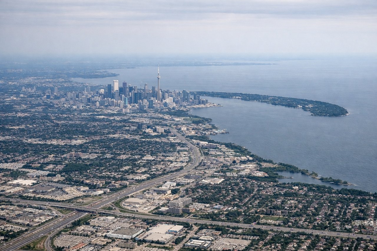
RIGHTYYZ's most common departure on runway 23 takes you northeast over the city. The right side gives you a clear view of downtown Toronto's skyline including the CN Tower, Lake Ontario's northern shoreline, and the Toronto Islands. Left side faces suburban sprawl toward Mississauga.
Landing at YDF
LEFTDeer Lake Airport typically uses runway 25 for westerly approaches, meaning aircraft arrive from the east over the interior of Newfoundland. The left side faces south toward Deer Lake itself and the Long Range Mountains, which are the dominant visual feature of western Newfoundland. Right side looks north toward less distinctive boreal terrain.
Will your flight be in sunlight?
Pick a date and time in the Sun Map to watch the sun move across your whole flight.
About This Route
Which side of the plane should I sit on flying from Lester B Pearson International (YYZ) to Deer Lake (YDF)?
Sit on the Right side of the plane for the best views on flights from Toronto to Deer Lake. The right side wins overall due to the spectacular Toronto departure view with the CN Tower and Lake Ontario. The landing view on the left is compelling but the takeoff moment is more dramatic and memorable. During cruise, both sides offer similar boreal forest and Quebec lake district scenery, so the takeoff experience tips the balance to the right.
What can I see during takeoff from Lester B Pearson International in Toronto?
During takeoff from Lester B Pearson International (YYZ), sit on the Right side for the best views. YYZ's most common departure on runway 23 takes you northeast over the city. The right side gives you a clear view of downtown Toronto's skyline including the CN Tower, Lake Ontario's northern shoreline, and the Toronto Islands. Left side faces suburban sprawl toward Mississauga. Notable sights include: CN Tower and downtown Toronto skyline, Toronto Islands and Billy Bishop Airport, Lake Ontario northern shoreline, Scarborough Bluffs along the lakeshore.
What can I see when landing at Deer Lake in Deer Lake?
When landing at Deer Lake (YDF), sit on the Left side for the best views. Deer Lake Airport typically uses runway 25 for westerly approaches, meaning aircraft arrive from the east over the interior of Newfoundland. The left side faces south toward Deer Lake itself and the Long Range Mountains, which are the dominant visual feature of western Newfoundland. Right side looks north toward less distinctive boreal terrain. Notable sights include: Deer Lake (the actual lake), Long Range Mountains to the south, Humber River valley, Gros Morne National Park highlands visible to the northwest.
How long is the flight from Toronto to Deer Lake?
The flight from Lester B Pearson International (YYZ) to Deer Lake (YDF) takes about 2 hours 25 minutes. The shortest flight path between them is 1,120 miles (1,803 km); winds and air traffic control usually add a few percent.
What does the Toronto to Deer Lake flight path pass over?
The flight tracks northeast over the Canadian Shield of Ontario, crossing the Ottawa River valley and the Laurentian Highlands of Quebec. Over Quebec, the landscape is dominated by thousands of lakes and rivers of the boreal shield. The flight then crosses the St. Lawrence River near the lower estuary, a wide dramatic waterway visible from altitude. Approaching Newfoundland, the aircraft crosses the Strait of Belle Isle or the Gulf of St. Lawrence before reaching the island's western coast near the Long Range Mountains.