Faleolo to Auckland is 1,797 miles (2,892 km), a flight of about 3 hours 15 minutes.
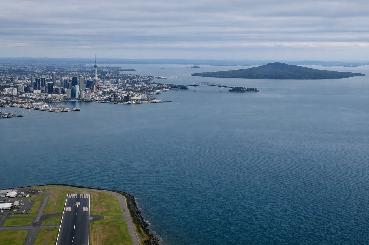
While takeoff favors the right for Upolu's interior, the landing view from the left is significantly more dramatic and geographically interesting, featuring Rangitoto and Auckland Harbour. The left side captures the most distinctive visual landmarks of the entire route.
Flight Path
The flight path crosses the South Pacific between Samoa and New Zealand, passing over open ocean with no significant landmarks. Around the midpoint (roughly 1,000 nautical miles southeast of Samoa), you'll be over deep ocean with occasional weather systems visible. The Kermadec Islands lie south of the direct flight path and are not typically visible. The approach to New Zealand begins showing the North Island's landmass approximately 200 nautical miles out, with the Coromandel Peninsula and Bay of Plenty becoming visible before the descent into Auckland.
Great circle distance and headings ›

Phase by phase
Takeoff from APW
RIGHTFaleolo typically departs runway 06/24. Departing eastbound (runway 06) on a right-side seat gives you the best view of Upolu island's volcanic interior and the north coast as you climb. Westbound departures (runway 24) would show ocean immediately.
Landing at AKL
LEFTAuckland typically lands runway 03R/21L or 03L/21R depending on wind. Approaching from the northeast (runway 03), a left-side seat provides excellent views of the Waitemata Harbour, Rangitoto volcanic cone, and the city skyline. The descent path brings these landmarks into clear view on the left side of the aircraft.
Landmarks on this routeAll landmarks →
Will your flight be in sunlight?
Pick a date and time in the Sun Map to watch the sun move across your whole flight.
About This Route
Which side of the plane should I sit on flying from Faleolo International (APW) to Auckland International (AKL)?
Sit on the Left side of the plane for the best views on flights from Faleolo to Auckland. While takeoff favors the right for Upolu's interior, the landing view from the left is significantly more dramatic and geographically interesting, featuring Rangitoto and Auckland Harbour. The left side captures the most distinctive visual landmarks of the entire route.
What can I see during takeoff from Faleolo International in Faleolo?
During takeoff from Faleolo International (APW), sit on the Right side for the best views. Faleolo typically departs runway 06/24. Departing eastbound (runway 06) on a right-side seat gives you the best view of Upolu island's volcanic interior and the north coast as you climb. Westbound departures (runway 24) would show ocean immediately. Notable sights include: Upolu's central volcanic ridge, Apolima Strait (narrow channel between Upolu and Apolima island to the west), north coast reef systems, and the gradual transition from island terrain to open Pacific.
What can I see when landing at Auckland International in Auckland?
When landing at Auckland International (AKL), sit on the Left side for the best views. Auckland typically lands runway 03R/21L or 03L/21R depending on wind. Approaching from the northeast (runway 03), a left-side seat provides excellent views of the Waitemata Harbour, Rangitoto volcanic cone, and the city skyline. The descent path brings these landmarks into clear view on the left side of the aircraft. Notable sights include: Rangitoto Island (distinctive volcanic cone in Waitemata Harbour), Waitemata Harbour with its numerous bays and inlets, Auckland's CBD skyline and waterfront, and the Waitakere Ranges to the west.
How long is the flight from Faleolo to Auckland?
The flight from Faleolo International (APW) to Auckland International (AKL) takes about 3 hours 15 minutes. The shortest flight path between them is 1,797 miles (2,892 km); winds and air traffic control usually add a few percent.
What does the Faleolo to Auckland flight path pass over?
The flight path crosses the South Pacific between Samoa and New Zealand, passing over open ocean with no significant landmarks. Around the midpoint (roughly 1,000 nautical miles southeast of Samoa), you'll be over deep ocean with occasional weather systems visible. The Kermadec Islands lie south of the direct flight path and are not typically visible. The approach to New Zealand begins showing the North Island's landmass approximately 200 nautical miles out, with the Coromandel Peninsula and Bay of Plenty becoming visible before the descent into Auckland.