The right side strings together the flight's best scenery: the Atlanta skyline at takeoff, glimpses of the northern Rockies during cruise, and a sustained view of downtown Seattle, Puget Sound, and the Olympic Mountains during the descent and final turn into SEA.
Flight Path
The route crosses the Tennessee River Valley and Ozark Plateau, then the flat farmland of the Great Plains through Nebraska and South Dakota, before climbing terrain near the Rocky Mountain Front in Montana and the Bitterroot Range in Idaho ahead of the final descent through the Cascades.
Great circle distance and headings ›.jpeg?width=600)

.jpg?width=600)
.jpg?width=600)

Phase by phase

Takeoff from ATL
RIGHTUnder normal west-flow departures ATL planes lift off heading west then bank right toward the northwest cruise track, swinging the right side of the cabin across downtown Atlanta's skyline and the granite dome of Stone Mountain just beyond it. The left side mostly shows suburban sprawl and flat Piedmont terrain during the turn.
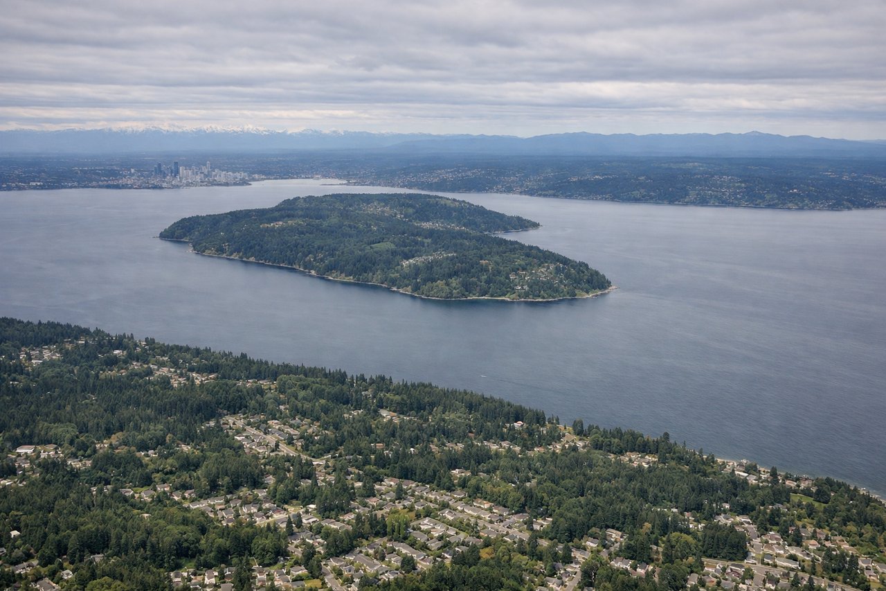
Landing at SEA
RIGHTArriving from the east over the Cascades, the aircraft descends into the Puget Sound lowlands and turns to line up with SEA's north-south runways, sweeping the right side of the cabin across downtown Seattle's skyline, Elliott Bay, and the Olympic Mountains rising beyond the water. The left side faces inland toward the Cascade foothills and Lake Washington's less dramatic eastern shore.
Landmarks on this routeAll landmarks →
Will your flight be in sunlight?
See exactly which side of the plane gets sun and shade at your departure time.
About This Route
Which side of the plane should I sit on flying from The William B Hartsfield Atlanta International (ATL) to Seattle Tacoma International (SEA)?
Sit on the Right side of the plane for the best views on flights from Atlanta to Seattle. The right side strings together the flight's best scenery: the Atlanta skyline at takeoff, glimpses of the northern Rockies during cruise, and a sustained view of downtown Seattle, Puget Sound, and the Olympic Mountains during the descent and final turn into SEA.
What can I see during takeoff from The William B Hartsfield Atlanta International in Atlanta?
During takeoff from The William B Hartsfield Atlanta International (ATL), sit on the Right side for the best views. Under normal west-flow departures ATL planes lift off heading west then bank right toward the northwest cruise track, swinging the right side of the cabin across downtown Atlanta's skyline and the granite dome of Stone Mountain just beyond it. The left side mostly shows suburban sprawl and flat Piedmont terrain during the turn. Notable sights include: Downtown Atlanta skyline, Stone Mountain, Chattahoochee River, Atlanta suburbs.
What can I see when landing at Seattle Tacoma International in Seattle?
When landing at Seattle Tacoma International (SEA), sit on the Right side for the best views. Arriving from the east over the Cascades, the aircraft descends into the Puget Sound lowlands and turns to line up with SEA's north-south runways, sweeping the right side of the cabin across downtown Seattle's skyline, Elliott Bay, and the Olympic Mountains rising beyond the water. The left side faces inland toward the Cascade foothills and Lake Washington's less dramatic eastern shore. Notable sights include: Downtown Seattle skyline, Elliott Bay/Puget Sound, Olympic Mountains, Lake Washington.
How long is the flight from Atlanta to Seattle?
The flight from The William B Hartsfield Atlanta International (ATL) to Seattle Tacoma International (SEA) takes 5h10m.
What does the Atlanta to Seattle flight path pass over?
The route crosses the Tennessee River Valley and Ozark Plateau, then the flat farmland of the Great Plains through Nebraska and South Dakota, before climbing terrain near the Rocky Mountain Front in Montana and the Bitterroot Range in Idaho ahead of the final descent through the Cascades.