While Cairo's Nile Delta departure is visually distinctive, Shanghai's landing sequence offers superior scenic value: the Yangtze estuary, Hangzhou Bay, and Pudong's iconic skyline provide dramatic urban and coastal scenery that outweighs the cruise phase's relatively monotonous central Asian plains. The right side captures two major geographic features (estuary and bay) plus world-class urban architecture during approach, scoring higher overall.
Flown CAI to SHA? Did we get it right?
Flight Path
Cairo to Shanghai is 5,174 miles (8,327 km), a flight of about 10 hours 10 minutes.
Caspian Sea (southern shore, distant), Turkmenistan and Uzbekistan steppes, Tian Shan mountains (northern horizon), Taklamakan Desert (southern route), Gobi Desert transition zone, Yellow River valley (eastern approach to China)
Great circle distance and headings ›Phase by phase
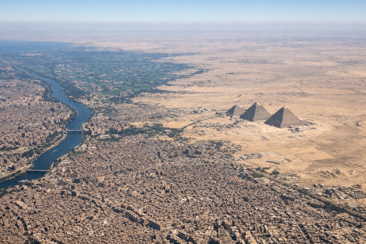
Takeoff from CAI
LEFTCairo's urban sprawl and the Nile Delta are visible on the left (north) side during northeast-heading departures. The Nile's distinctive green ribbon cutting through desert, Cairo's dense cityscape, and the flat delta plain provide immediate geographic context. Right side shows only desert plateau.
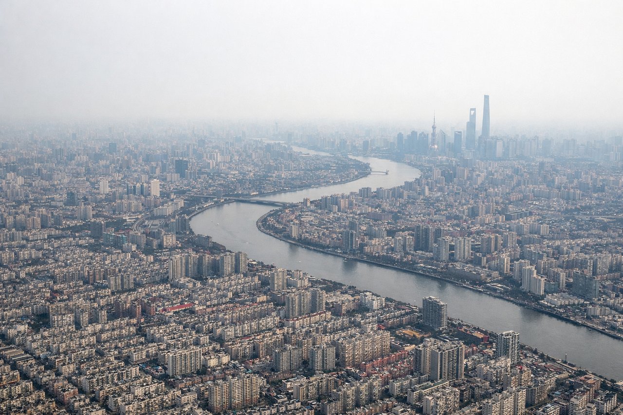
Landing at SHA
RIGHTShanghai's approach from the east (runway 36 operations, common in summer) offers views of the Yangtze River estuary, Hangzhou Bay, and the city's dramatic skyline. The right side captures the Huangpu River winding through Pudong's forest of skyscrapers, the port facilities, and the coastal wetlands. Left side shows only inland plains and industrial suburbs.
Will your flight be in sunlight?
Pick a date and time in the Sun Map to watch the sun move across your whole flight.
About This Route
Which side of the plane should I sit on flying from Cairo International (CAI) to Hongqiao International (SHA)?
Sit on the Right side of the plane for the best views on flights from Cairo to Shanghai. While Cairo's Nile Delta departure is visually distinctive, Shanghai's landing sequence offers superior scenic value: the Yangtze estuary, Hangzhou Bay, and Pudong's iconic skyline provide dramatic urban and coastal scenery that outweighs the cruise phase's relatively monotonous central Asian plains. The right side captures two major geographic features (estuary and bay) plus world-class urban architecture during approach, scoring higher overall.
What can I see during takeoff from Cairo International in Cairo?
During takeoff from Cairo International (CAI), sit on the Left side for the best views. Cairo's urban sprawl and the Nile Delta are visible on the left (north) side during northeast-heading departures. The Nile's distinctive green ribbon cutting through desert, Cairo's dense cityscape, and the flat delta plain provide immediate geographic context. Right side shows only desert plateau. Notable sights include: Nile River Delta, Cairo metropolitan area, Suez Canal approach (distant), Eastern Desert plateau.
What can I see when landing at Hongqiao International in Shanghai?
When landing at Hongqiao International (SHA), sit on the Right side for the best views. Shanghai's approach from the east (runway 36 operations, common in summer) offers views of the Yangtze River estuary, Hangzhou Bay, and the city's dramatic skyline. The right side captures the Huangpu River winding through Pudong's forest of skyscrapers, the port facilities, and the coastal wetlands. Left side shows only inland plains and industrial suburbs. Notable sights include: Yangtze River estuary, Hangzhou Bay, Pudong skyline and Oriental Pearl Tower, Huangpu River.
How long is the flight from Cairo to Shanghai?
The flight from Cairo International (CAI) to Hongqiao International (SHA) takes about 10 hours 10 minutes. The shortest flight path between them is 5,174 miles (8,327 km); winds and air traffic control usually add a few percent.
What does the Cairo to Shanghai flight path pass over?
Caspian Sea (southern shore, distant), Turkmenistan and Uzbekistan steppes, Tian Shan mountains (northern horizon), Taklamakan Desert (southern route), Gobi Desert transition zone, Yellow River valley (eastern approach to China)