The left side wins on both ends of the flight — Istanbul's iconic Bosphorus and historic skyline at departure, and a rare glimpse of London's skyline on approach into Luton — while the right side offers mostly flat, unremarkable countryside throughout.
Flown IST to LTN? Did we get it right?
Flight Path
Istanbul to London is 1,550 miles (2,494 km), a flight of about 4 hours 15 minutes.
Balkan mountain ranges over Bulgaria and Serbia, the Pannonian Plain over Hungary, and the northern edge of the Alps visible in the distance over Austria and southern Germany before the route flattens out over the Rhine plain and the North Sea coast.
Great circle distance and headings ›


Phase by phase
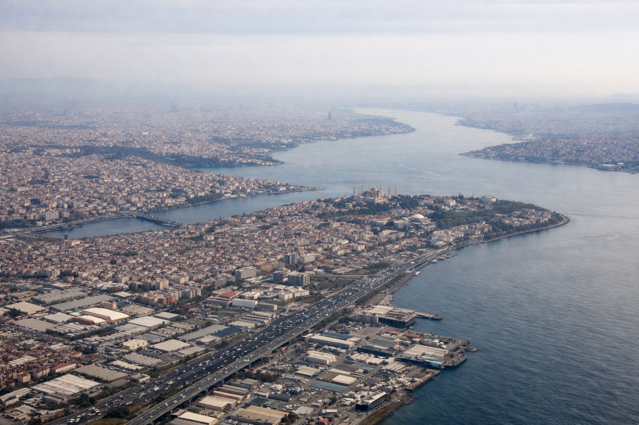
Takeoff from IST
LEFTDeparting IST, aircraft typically climb out and turn west toward Europe, putting the Istanbul cityscape, the Bosphorus strait, and the Sea of Marmara coastline on the left side of the aircraft. The right side mostly shows the flatter Thracian countryside and a glimpse of the Black Sea coast fading behind.
Landing at LTN
LEFTOn approach into LTN from the east, the flight path passes just north of London, and standard descent patterns for runway 25 put London's skyline and the Thames valley on the left side of the aircraft. The right side shows mostly the flatter Chiltern countryside with little urban detail.
Will your flight be in sunlight?
Pick a date and time in the Sun Map to watch the sun move across your whole flight.
About This Route
Which side of the plane should I sit on flying from İstanbul Airport (IST) to Luton (LTN)?
Sit on the Left side of the plane for the best views on flights from Istanbul to London. The left side wins on both ends of the flight — Istanbul's iconic Bosphorus and historic skyline at departure, and a rare glimpse of London's skyline on approach into Luton — while the right side offers mostly flat, unremarkable countryside throughout.
What can I see during takeoff from İstanbul Airport in Istanbul?
During takeoff from İstanbul Airport (IST), sit on the Left side for the best views. Departing IST, aircraft typically climb out and turn west toward Europe, putting the Istanbul cityscape, the Bosphorus strait, and the Sea of Marmara coastline on the left side of the aircraft. The right side mostly shows the flatter Thracian countryside and a glimpse of the Black Sea coast fading behind. Notable sights include: Bosphorus Strait, Istanbul's historic peninsula, Sea of Marmara, Princes' Islands.
What can I see when landing at Luton in London?
When landing at Luton (LTN), sit on the Left side for the best views. On approach into LTN from the east, the flight path passes just north of London, and standard descent patterns for runway 25 put London's skyline and the Thames valley on the left side of the aircraft. The right side shows mostly the flatter Chiltern countryside with little urban detail. Notable sights include: London skyline (The Shard, Canary Wharf towers), River Thames bends, Chiltern Hills.
How long is the flight from Istanbul to London?
The flight from İstanbul Airport (IST) to Luton (LTN) takes about 4 hours 15 minutes. The shortest flight path between them is 1,550 miles (2,494 km); winds and air traffic control usually add a few percent.
What does the Istanbul to London flight path pass over?
Balkan mountain ranges over Bulgaria and Serbia, the Pannonian Plain over Hungary, and the northern edge of the Alps visible in the distance over Austria and southern Germany before the route flattens out over the Rhine plain and the North Sea coast.