The left side offers a stronger overall mix of scenery: a dramatic Panama City and Canal departure, followed by cruise views of the Pacific coastline and the volcanic peaks that line Central America's Pacific side, plus a glimpse of Catalina Island on descent. The right side has a strong finish over the LA basin but a weaker takeoff and a cruise phase dominated by less distinctive interior terrain.
Flown PTY to LAX? Did we get it right?
Flight Path
Panama City to Los Angeles is 3,011 miles (4,845 km), a flight of about 6 hours 55 minutes.
Southern Mexican highlands near Oaxaca and Guerrero, with the Pacific volcanic arc (peaks such as Fuego and Volcán de Colima) visible to the west along the coast as the route continues over Michoacán and Jalisco before crossing the Gulf of California toward Baja.
Great circle distance and headings ›

Phase by phase
Takeoff from PTY
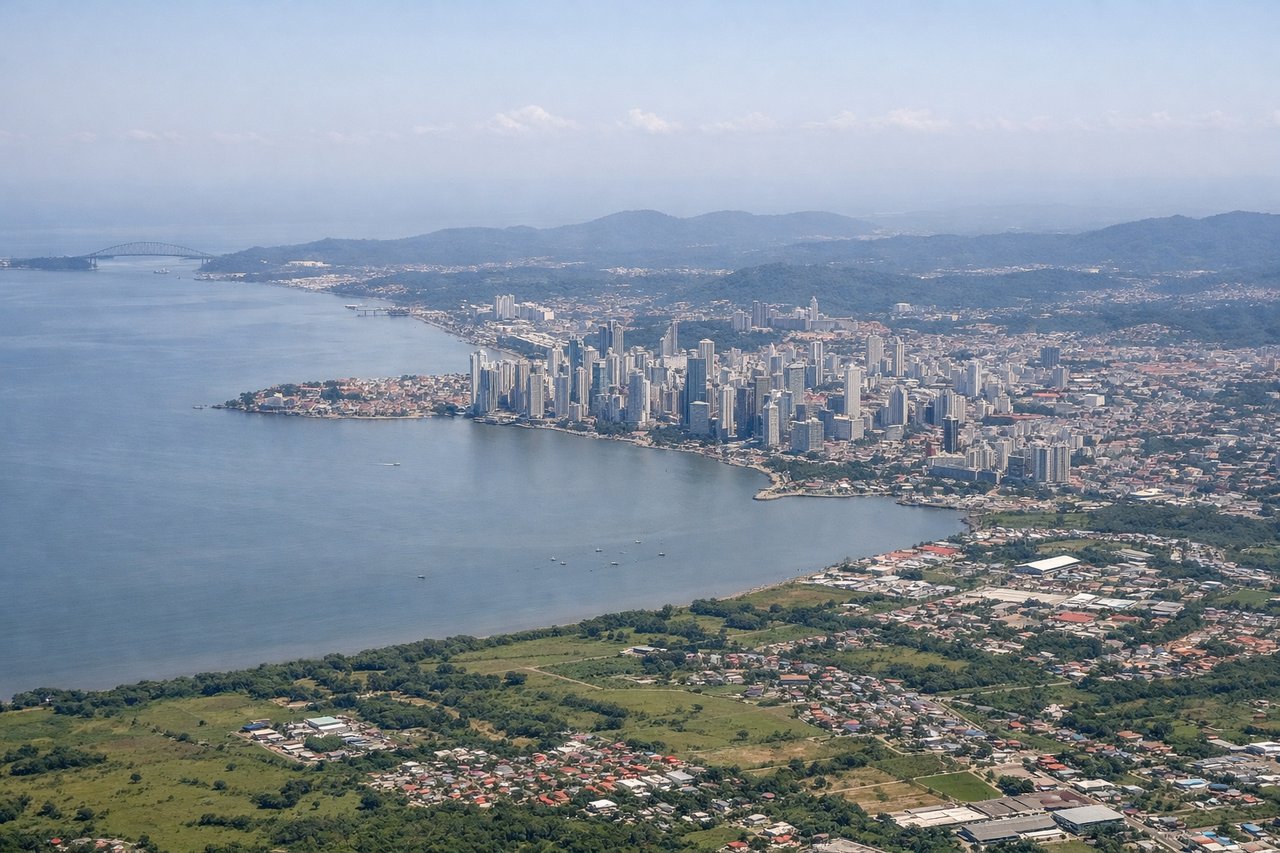
LEFTDeparting PTY toward the northwest, the initial turn swings over the Bay of Panama, giving a clear view of the Panama City skyline, the Bridge of the Americas, and the Pacific entrance to the Panama Canal. The right side instead faces the lowland rainforest interior toward the Canal's Caribbean side, which is far less visually striking.
Landing at LAX
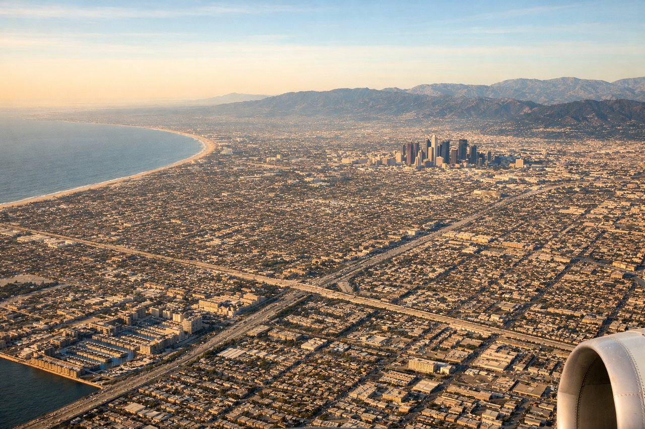
RIGHTOn the descent into LAX from the south, the aircraft crosses the Los Angeles basin before lining up on the westbound runways, and the right side faces north toward the San Gabriel Mountains and the Downtown LA skyline. The left side mainly shows the flatter South Bay industrial areas and harbor, which is less visually rewarding.
Will your flight be in sunlight?
Pick a date and time in the Sun Map to watch the sun move across your whole flight.
About This Route
Which side of the plane should I sit on flying from Tocumen International (PTY) to Los Angeles International (LAX)?
Sit on the Left side of the plane for the best views on flights from Panama City to Los Angeles. The left side offers a stronger overall mix of scenery: a dramatic Panama City and Canal departure, followed by cruise views of the Pacific coastline and the volcanic peaks that line Central America's Pacific side, plus a glimpse of Catalina Island on descent. The right side has a strong finish over the LA basin but a weaker takeoff and a cruise phase dominated by less distinctive interior terrain.
What can I see during takeoff from Tocumen International in Panama City?
During takeoff from Tocumen International (PTY), sit on the Left side for the best views. Departing PTY toward the northwest, the initial turn swings over the Bay of Panama, giving a clear view of the Panama City skyline, the Bridge of the Americas, and the Pacific entrance to the Panama Canal. The right side instead faces the lowland rainforest interior toward the Canal's Caribbean side, which is far less visually striking. Notable sights include: Panama City skyline, Bridge of the Americas, Bay of Panama, Pacific entrance locks of the Panama Canal.
What can I see when landing at Los Angeles International in Los Angeles?
When landing at Los Angeles International (LAX), sit on the Right side for the best views. On the descent into LAX from the south, the aircraft crosses the Los Angeles basin before lining up on the westbound runways, and the right side faces north toward the San Gabriel Mountains and the Downtown LA skyline. The left side mainly shows the flatter South Bay industrial areas and harbor, which is less visually rewarding. Notable sights include: San Gabriel Mountains, Downtown Los Angeles skyline, Hollywood Hills, Santa Monica Bay.
How long is the flight from Panama City to Los Angeles?
The flight from Tocumen International (PTY) to Los Angeles International (LAX) takes about 6 hours 55 minutes. The shortest flight path between them is 3,011 miles (4,845 km); winds and air traffic control usually add a few percent.
What does the Panama City to Los Angeles flight path pass over?
Southern Mexican highlands near Oaxaca and Guerrero, with the Pacific volcanic arc (peaks such as Fuego and Volcán de Colima) visible to the west along the coast as the route continues over Michoacán and Jalisco before crossing the Gulf of California toward Baja.