Reykjavik to Paris is 1,383 miles (2,225 km), a flight of about 3 hours 10 minutes.
The left side delivers the most dramatic single moment of the flight — the view of Mount Esja, Faxaflói Bay, and Reykjavik on departure. The landing views at CDG are relatively flat and agricultural on both sides, so the takeoff experience tips the balance decisively to the left.
Flight Path
The route tracks southeast from Iceland across the North Atlantic, crossing the Faroe Islands (visible as small dark specks in the ocean if conditions are clear), then over the Scottish Highlands and northern England, crossing the English Channel near the Strait of Dover, and descending over the flat plains of northern France. The Scottish Highlands may be visible as a dark mountainous mass from high altitude on clear days. The English Channel crossing is brief at cruising altitude.
Great circle distance and headings ›
.jpeg?width=600)

.jpg?width=600)
Phase by phase
Takeoff from RKV
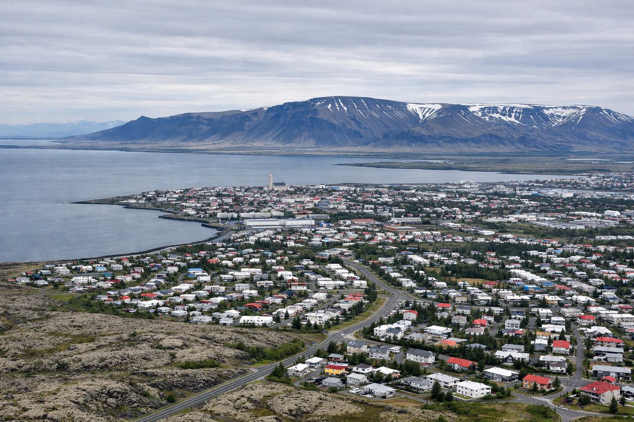
LEFTReykjavik City Airport (RKV) typically departs runway 13 heading southeast, which puts the left side facing northeast toward Mount Esja and Faxaflói Bay. You get a clear view of the city spread along the bay and the dramatic ridge of Esja rising behind it.
Landing at CDG
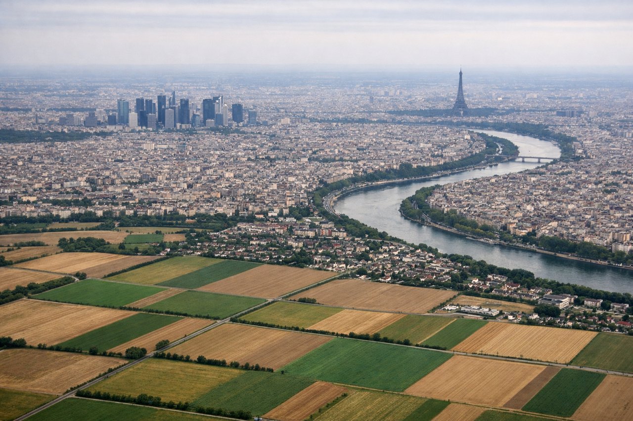
RIGHTCDG typically lands on runways 27L/27R heading west, meaning the right side faces north toward the Oise valley and the left faces south toward Paris. However, on approach from the northeast over the English Channel corridor, the right side actually captures the Seine valley and distant Paris skyline as you descend. On the more common easterly approach (runway 09 direction reversed), right side gives views over the Seine bends near Pontoise.
Landmarks on this routeAll landmarks →
Will your flight be in sunlight?
Pick a date and time in the Sun Map to watch the sun move across your whole flight.
About This Route
Which side of the plane should I sit on flying from Reykjavik (RKV) to Charles De Gaulle (CDG)?
Sit on the Left side of the plane for the best views on flights from Reykjavik to Paris. The left side delivers the most dramatic single moment of the flight — the view of Mount Esja, Faxaflói Bay, and Reykjavik on departure. The landing views at CDG are relatively flat and agricultural on both sides, so the takeoff experience tips the balance decisively to the left.
What can I see during takeoff from Reykjavik in Reykjavik?
During takeoff from Reykjavik (RKV), sit on the Left side for the best views. Reykjavik City Airport (RKV) typically departs runway 13 heading southeast, which puts the left side facing northeast toward Mount Esja and Faxaflói Bay. You get a clear view of the city spread along the bay and the dramatic ridge of Esja rising behind it. Notable sights include: Mount Esja (914m ridge north of Reykjavik), Faxaflói Bay, Reykjavik city center and Hallgrímskirkja church spire, Snæfellsnes Peninsula in the far distance.
What can I see when landing at Charles De Gaulle in Paris?
When landing at Charles De Gaulle (CDG), sit on the Right side for the best views. CDG typically lands on runways 27L/27R heading west, meaning the right side faces north toward the Oise valley and the left faces south toward Paris. However, on approach from the northeast over the English Channel corridor, the right side actually captures the Seine valley and distant Paris skyline as you descend. On the more common easterly approach (runway 09 direction reversed), right side gives views over the Seine bends near Pontoise. Notable sights include: Seine River bends near Pontoise and Conflans-Sainte-Honorine, Oise River confluence, the flat agricultural Île-de-France plain, distant Paris skyline on the horizon.
How long is the flight from Reykjavik to Paris?
The flight from Reykjavik (RKV) to Charles De Gaulle (CDG) takes about 3 hours 10 minutes. The shortest flight path between them is 1,383 miles (2,225 km); winds and air traffic control usually add a few percent.
What does the Reykjavik to Paris flight path pass over?
The route tracks southeast from Iceland across the North Atlantic, crossing the Faroe Islands (visible as small dark specks in the ocean if conditions are clear), then over the Scottish Highlands and northern England, crossing the English Channel near the Strait of Dover, and descending over the flat plains of northern France. The Scottish Highlands may be visible as a dark mountainous mass from high altitude on clear days. The English Channel crossing is brief at cruising altitude.