The left side captures San Francisco's iconic bay skyline at departure, catches glimpses of the Sierra Nevada and Rocky Mountains during cruise, and finishes with Atlanta's skyline and Stone Mountain on approach — giving it a clear edge over the right side's more monotonous plains and suburban views.
Flight Path
Sierra Nevada mountains, Great Basin desert of Nevada and Utah, southern Rocky Mountains near Colorado, and the Mississippi River valley are crossed along the route between San Francisco and Atlanta.
Great circle distance and headings ›


.jpg?width=600)

.jpg?width=600)

.jpeg?width=600)
Phase by phase
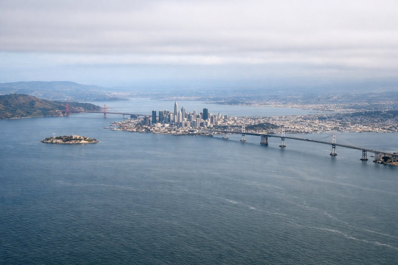
Takeoff from SFO
LEFTDeparting SFO's eastern runways, the initial climb tracks east over San Francisco Bay, putting the San Francisco skyline, Golden Gate Bridge, and Marin Headlands on the left side of the aircraft. The right side mostly shows the flatter East Bay suburbs and hills with less visual drama.
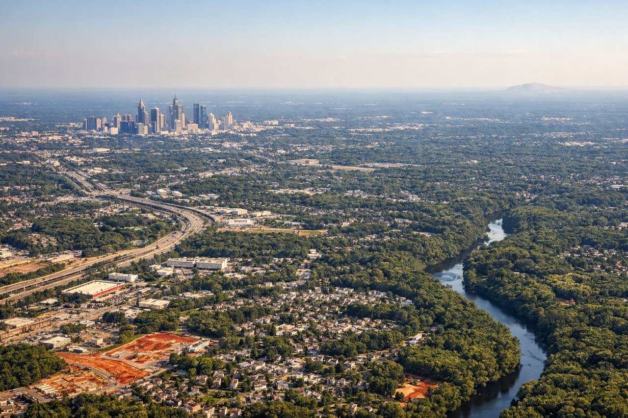
Landing at ATL
LEFTArriving into ATL from the west, the flight path continues east on final approach, keeping downtown Atlanta's skyline and the granite dome of Stone Mountain visible on the north (left) side. The right side faces mostly featureless suburban sprawl to the south.
Landmarks on this routeAll landmarks →
Will your flight be in sunlight?
See exactly which side of the plane gets sun and shade at your departure time.
About This Route
Which side of the plane should I sit on flying from San Francisco International (SFO) to The William B Hartsfield Atlanta International (ATL)?
Sit on the Left side of the plane for the best views on flights from San Francisco to Atlanta. The left side captures San Francisco's iconic bay skyline at departure, catches glimpses of the Sierra Nevada and Rocky Mountains during cruise, and finishes with Atlanta's skyline and Stone Mountain on approach — giving it a clear edge over the right side's more monotonous plains and suburban views.
What can I see during takeoff from San Francisco International in San Francisco?
During takeoff from San Francisco International (SFO), sit on the Left side for the best views. Departing SFO's eastern runways, the initial climb tracks east over San Francisco Bay, putting the San Francisco skyline, Golden Gate Bridge, and Marin Headlands on the left side of the aircraft. The right side mostly shows the flatter East Bay suburbs and hills with less visual drama. Notable sights include: San Francisco skyline, Golden Gate Bridge, San Francisco Bay, Marin Headlands.
What can I see when landing at The William B Hartsfield Atlanta International in Atlanta?
When landing at The William B Hartsfield Atlanta International (ATL), sit on the Left side for the best views. Arriving into ATL from the west, the flight path continues east on final approach, keeping downtown Atlanta's skyline and the granite dome of Stone Mountain visible on the north (left) side. The right side faces mostly featureless suburban sprawl to the south. Notable sights include: Downtown Atlanta skyline, Stone Mountain, Chattahoochee River, Georgia Piedmont forest.
How long is the flight from San Francisco to Atlanta?
The flight from San Francisco International (SFO) to The William B Hartsfield Atlanta International (ATL) takes 4h 20m.
What does the San Francisco to Atlanta flight path pass over?
Sierra Nevada mountains, Great Basin desert of Nevada and Utah, southern Rocky Mountains near Colorado, and the Mississippi River valley are crossed along the route between San Francisco and Atlanta.