The right side strings together the most distinctive landmarks of the whole route: Mount Hamilton on departure, the Tehachapi and San Gabriel Mountains flanking the Mojave Desert during cruise, and Camelback Mountain with the Phoenix skyline on arrival. The left side's Santa Cruz Mountains and southern Sierra Nevada glimpses are pleasant but less varied and less consistently visible.
Flown SJC to PHX? Did we get it right?
Flight Path
San Jose to Phoenix is 621 miles (999 km), a flight of about 1 hour 55 minutes.
Southern Sierra Nevada foothills near Tehachapi, the Mojave Desert basin, the San Gabriel Mountains to the south, and the Colorado River crossing near the California-Arizona border before the descent into the Sonoran Desert around Phoenix
Great circle distance and headings ›Phase by phase
Takeoff from SJC
RIGHTDeparting SJC on runway 30, the climb-out and right turn toward the southeast swing the right side toward the Diablo Range, giving a clear look at Mount Hamilton's observatory domes above the Santa Clara Valley floor. The left side mostly shows the lower, less distinctive Santa Cruz Mountain foothills.
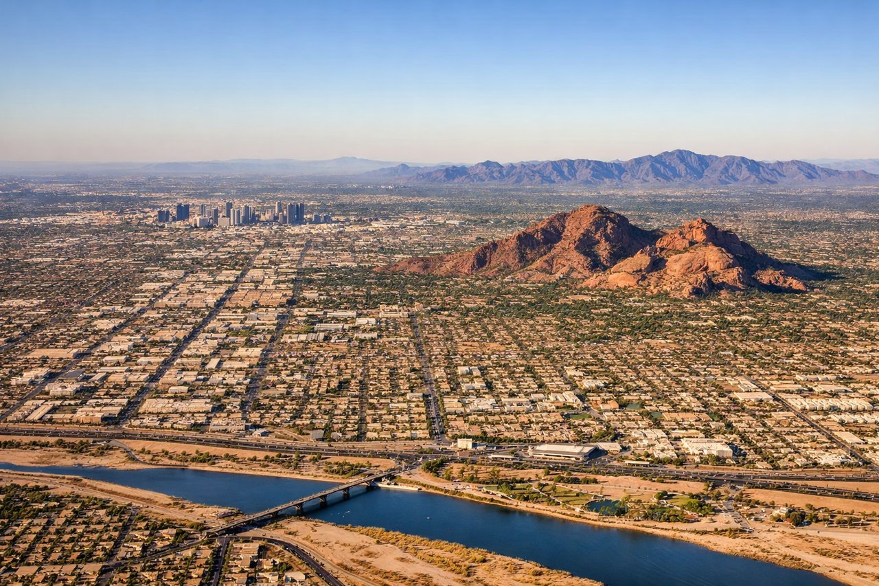
Landing at PHX
RIGHTOn a typical west-flow approach into Sky Harbor, the final turn to the west puts the right side facing north, revealing Camelback Mountain, Piestewa Peak, and the downtown Phoenix skyline rising from the desert floor. The left side instead faces the flatter, less varied terrain south of the airport.
Will your flight be in sunlight?
Pick a date and time in the Sun Map to watch the sun move across your whole flight.
About This Route
Which side of the plane should I sit on flying from Norman Y Mineta San Jose International (SJC) to Phoenix Sky Harbor International (PHX)?
Sit on the Right side of the plane for the best views on flights from San Jose to Phoenix. The right side strings together the most distinctive landmarks of the whole route: Mount Hamilton on departure, the Tehachapi and San Gabriel Mountains flanking the Mojave Desert during cruise, and Camelback Mountain with the Phoenix skyline on arrival. The left side's Santa Cruz Mountains and southern Sierra Nevada glimpses are pleasant but less varied and less consistently visible.
What can I see during takeoff from Norman Y Mineta San Jose International in San Jose?
During takeoff from Norman Y Mineta San Jose International (SJC), sit on the Right side for the best views. Departing SJC on runway 30, the climb-out and right turn toward the southeast swing the right side toward the Diablo Range, giving a clear look at Mount Hamilton's observatory domes above the Santa Clara Valley floor. The left side mostly shows the lower, less distinctive Santa Cruz Mountain foothills. Notable sights include: Mount Hamilton and Lick Observatory, Diablo Range foothills, downtown San Jose and Santa Clara Valley.
What can I see when landing at Phoenix Sky Harbor International in Phoenix?
When landing at Phoenix Sky Harbor International (PHX), sit on the Right side for the best views. On a typical west-flow approach into Sky Harbor, the final turn to the west puts the right side facing north, revealing Camelback Mountain, Piestewa Peak, and the downtown Phoenix skyline rising from the desert floor. The left side instead faces the flatter, less varied terrain south of the airport. Notable sights include: Camelback Mountain, Piestewa Peak, downtown Phoenix skyline, McDowell Mountains.
How long is the flight from San Jose to Phoenix?
The flight from Norman Y Mineta San Jose International (SJC) to Phoenix Sky Harbor International (PHX) takes about 1 hour 55 minutes. The shortest flight path between them is 621 miles (999 km); winds and air traffic control usually add a few percent.
What does the San Jose to Phoenix flight path pass over?
Southern Sierra Nevada foothills near Tehachapi, the Mojave Desert basin, the San Gabriel Mountains to the south, and the Colorado River crossing near the California-Arizona border before the descent into the Sonoran Desert around Phoenix