Right side scores higher (3.5 vs 2.5) due to superior takeoff scenery from the Sierra Nevada foothills and the dramatic mountain terrain visible during the entire climb-out and cruise phase. While left side offers excellent landing views of Puget Sound and Seattle, the right side's extended mountain scenery during the longer cruise portion outweighs the landing advantage. The Sierra Nevada provides sustained visual interest for the first 45 minutes of flight, whereas the landing sequence is brief.
Flown FAT to BFI? Did we get it right?
Flight Path
Fresno to Seattle is 754 miles (1,214 km), a flight of about 2 hours 15 minutes.
Kern River canyon and Sierra Nevada crest (first 45 minutes); transition over the southern Cascade Range and Mount Shasta region (around 1h 00m); descent into the Willamette Valley and approach to the Cascade Range western slopes near Portland (1h 30m onward); final descent over the Puget Sound lowlands and Cascade foothills
Great circle distance and headings ›Phase by phase
Takeoff from FAT
RIGHTRight-side departures from FAT typically use runway 29 (northwest-bound), offering immediate views of the Sierra Nevada foothills rising east of the Central Valley. Left-side departures see only flat agricultural terrain extending westward toward the Coast Ranges.
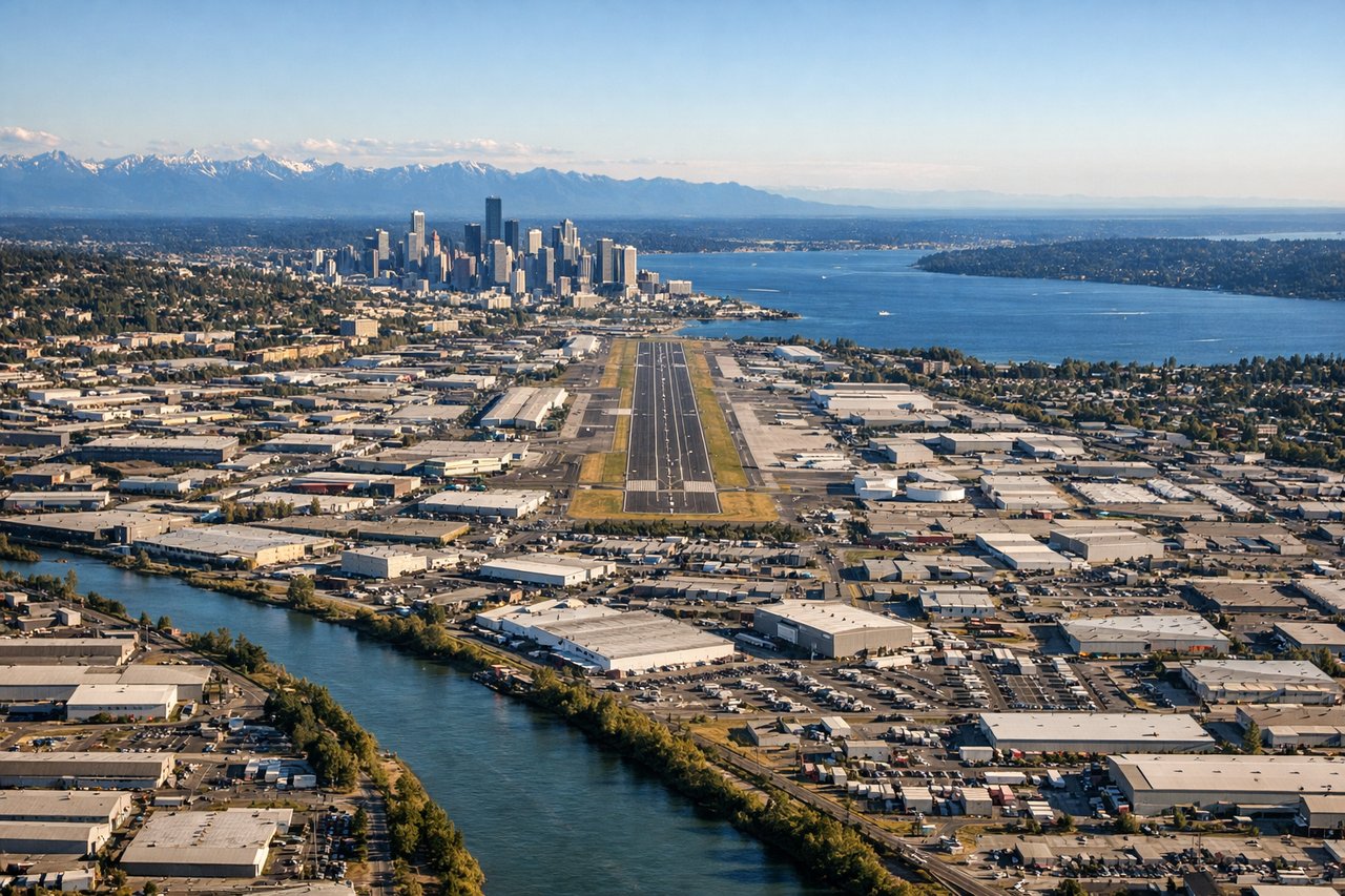
Landing at BFI
LEFTLeft-side approaches into BFI descend over Puget Sound and the Seattle waterfront, offering views of Elliott Bay, downtown Seattle's skyline, and the Olympic Mountains across the water. Right-side approaches descend over suburban Renton and the flat Duwamish Valley with minimal scenic interest.
Will your flight be in sunlight?
Pick a date and time in the Sun Map to watch the sun move across your whole flight.
About This Route
Which side of the plane should I sit on flying from Fresno Yosemite International (FAT) to Boeing Fld King Co International (BFI)?
Sit on the Right side of the plane for the best views on flights from Fresno to Seattle. Right side scores higher (3.5 vs 2.5) due to superior takeoff scenery from the Sierra Nevada foothills and the dramatic mountain terrain visible during the entire climb-out and cruise phase. While left side offers excellent landing views of Puget Sound and Seattle, the right side's extended mountain scenery during the longer cruise portion outweighs the landing advantage. The Sierra Nevada provides sustained visual interest for the first 45 minutes of flight, whereas the landing sequence is brief.
What can I see during takeoff from Fresno Yosemite International in Fresno?
During takeoff from Fresno Yosemite International (FAT), sit on the Right side for the best views. Right-side departures from FAT typically use runway 29 (northwest-bound), offering immediate views of the Sierra Nevada foothills rising east of the Central Valley. Left-side departures see only flat agricultural terrain extending westward toward the Coast Ranges. Notable sights include: Sierra Nevada eastern escarpment, Sequoia National Park high peaks (distant), Central Valley agricultural grid, Kern River canyon system.
What can I see when landing at Boeing Fld King Co International in Seattle?
When landing at Boeing Fld King Co International (BFI), sit on the Left side for the best views. Left-side approaches into BFI descend over Puget Sound and the Seattle waterfront, offering views of Elliott Bay, downtown Seattle's skyline, and the Olympic Mountains across the water. Right-side approaches descend over suburban Renton and the flat Duwamish Valley with minimal scenic interest. Notable sights include: Elliott Bay and Puget Sound, Seattle downtown skyline and Space Needle, Olympic Mountains (western horizon), Lake Washington and Mercer Island.
How long is the flight from Fresno to Seattle?
The flight from Fresno Yosemite International (FAT) to Boeing Fld King Co International (BFI) takes about 2 hours 15 minutes. The shortest flight path between them is 754 miles (1,214 km); winds and air traffic control usually add a few percent.
What does the Fresno to Seattle flight path pass over?
Kern River canyon and Sierra Nevada crest (first 45 minutes); transition over the southern Cascade Range and Mount Shasta region (around 1h 00m); descent into the Willamette Valley and approach to the Cascade Range western slopes near Portland (1h 30m onward); final descent over the Puget Sound lowlands and Cascade foothills