Right side scores higher due to the superior landing approach into Kuala Lumpur, where the Petronas Twin Towers, city skyline, and airport complex provide dramatic urban scenery and clear landmarks. While left side offers excellent San Francisco Bay departure views, the 17+ hour flight is dominated by open Pacific Ocean (5+ hours) and Southeast Asian coastlines with less concentrated visual drama. Right side's landing sequence outweighs left side's takeoff advantage.
Flown SFO to KUL? Did we get it right?
Flight Path
San Francisco to Kuala Lumpur is 8,472 miles (13,635 km), a flight of about 17 hours 15 minutes.
Pacific Ocean (open water for 8-10 hours), Hawaiian Islands (distant, typically not visible on standard routing), Micronesian island chains (Marshall Islands, Palau region—small atolls visible only at lower altitudes), Philippine Sea, Luzon Strait, Philippine archipelago (Luzon, Mindanao visible as large landmasses), Sulu Sea, Borneo (northern coast and interior highlands), Brunei coast, Strait of Malacca approach to Malaysia
Great circle distance and headings ›Phase by phase
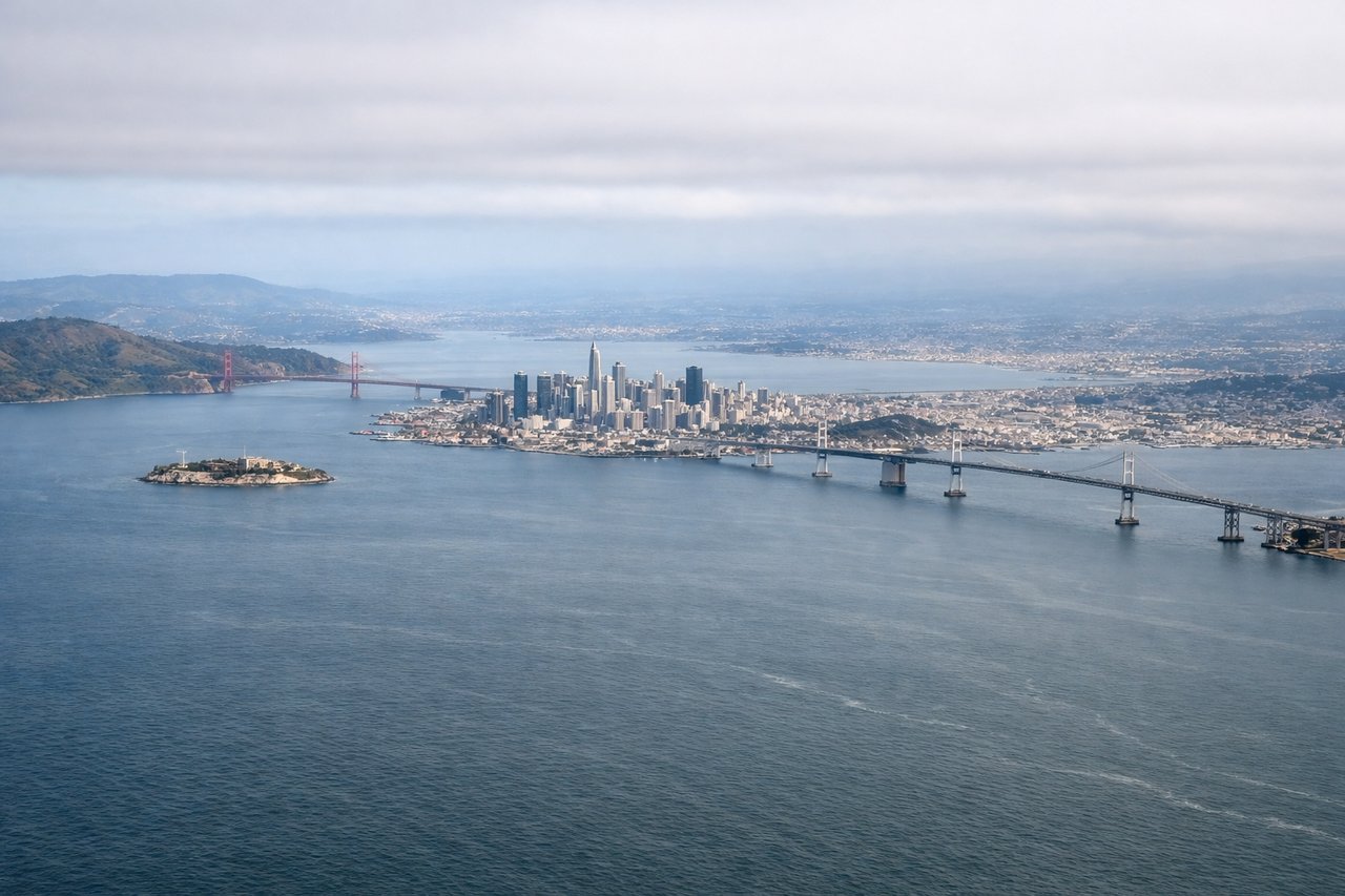
Takeoff from SFO
LEFTLeft side captures San Francisco Bay, the Golden Gate Bridge, and the Marin Headlands during departure. Right side faces inland toward the Central Valley with minimal visual interest during climb-out.
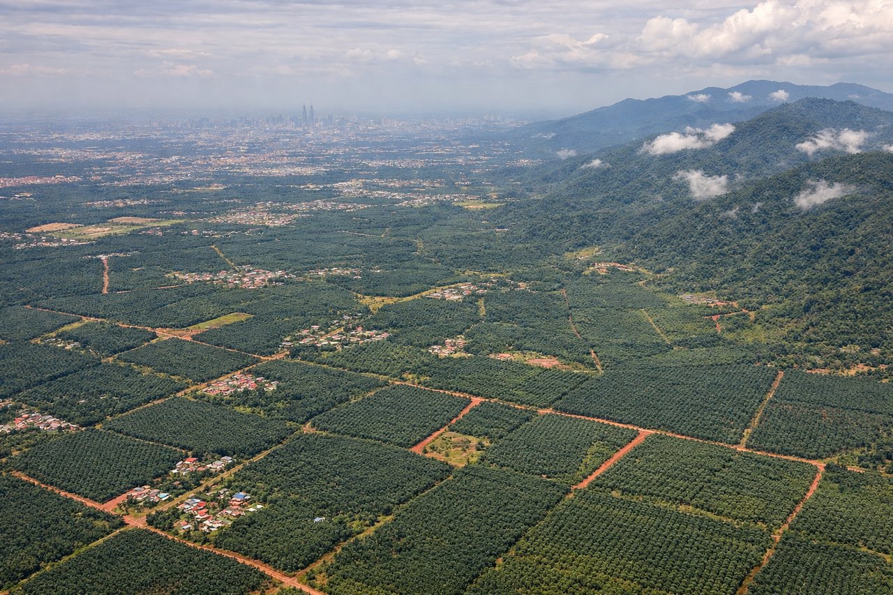
Landing at KUL
RIGHTRight side offers superior approach views into Kuala Lumpur International Airport. The descent path typically brings the Klang Valley, Petronas Twin Towers, and the city skyline into clear view. Left side faces the Strait of Malacca and open water with less dramatic urban scenery.
Will your flight be in sunlight?
Pick a date and time in the Sun Map to watch the sun move across your whole flight.
About This Route
Which side of the plane should I sit on flying from San Francisco International (SFO) to Kuala Lumpur International (KUL)?
Sit on the Right side of the plane for the best views on flights from San Francisco to Kuala Lumpur. Right side scores higher due to the superior landing approach into Kuala Lumpur, where the Petronas Twin Towers, city skyline, and airport complex provide dramatic urban scenery and clear landmarks. While left side offers excellent San Francisco Bay departure views, the 17+ hour flight is dominated by open Pacific Ocean (5+ hours) and Southeast Asian coastlines with less concentrated visual drama. Right side's landing sequence outweighs left side's takeoff advantage.
What can I see during takeoff from San Francisco International in San Francisco?
During takeoff from San Francisco International (SFO), sit on the Left side for the best views. Left side captures San Francisco Bay, the Golden Gate Bridge, and the Marin Headlands during departure. Right side faces inland toward the Central Valley with minimal visual interest during climb-out. Notable sights include: San Francisco Bay, Golden Gate Bridge, Marin Headlands, San Francisco skyline.
What can I see when landing at Kuala Lumpur International in Kuala Lumpur?
When landing at Kuala Lumpur International (KUL), sit on the Right side for the best views. Right side offers superior approach views into Kuala Lumpur International Airport. The descent path typically brings the Klang Valley, Petronas Twin Towers, and the city skyline into clear view. Left side faces the Strait of Malacca and open water with less dramatic urban scenery. Notable sights include: Petronas Twin Towers, Kuala Lumpur skyline, Klang Valley, Kuala Lumpur International Airport runway complex.
How long is the flight from San Francisco to Kuala Lumpur?
The flight from San Francisco International (SFO) to Kuala Lumpur International (KUL) takes about 17 hours 15 minutes. The shortest flight path between them is 8,472 miles (13,635 km); winds and air traffic control usually add a few percent.
What does the San Francisco to Kuala Lumpur flight path pass over?
Pacific Ocean (open water for 8-10 hours), Hawaiian Islands (distant, typically not visible on standard routing), Micronesian island chains (Marshall Islands, Palau region—small atolls visible only at lower altitudes), Philippine Sea, Luzon Strait, Philippine archipelago (Luzon, Mindanao visible as large landmasses), Sulu Sea, Borneo (northern coast and interior highlands), Brunei coast, Strait of Malacca approach to Malaysia