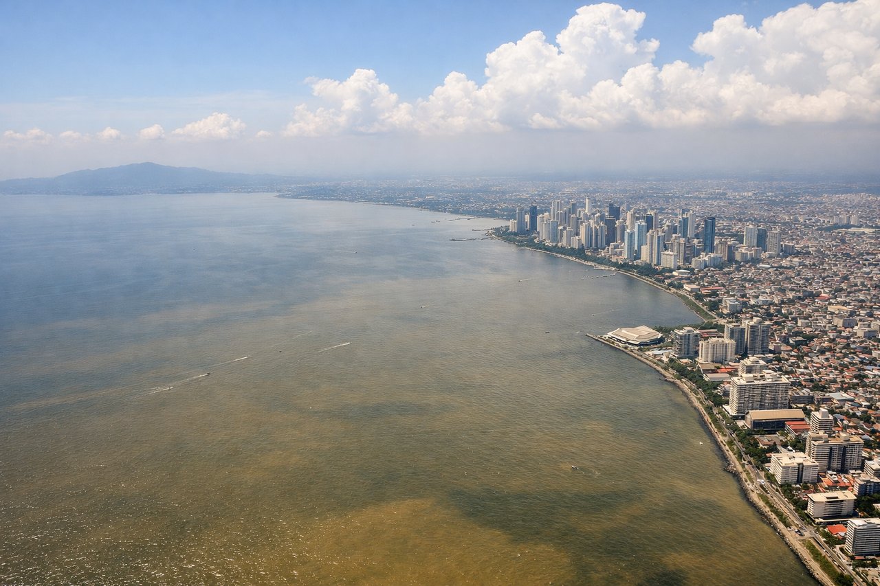
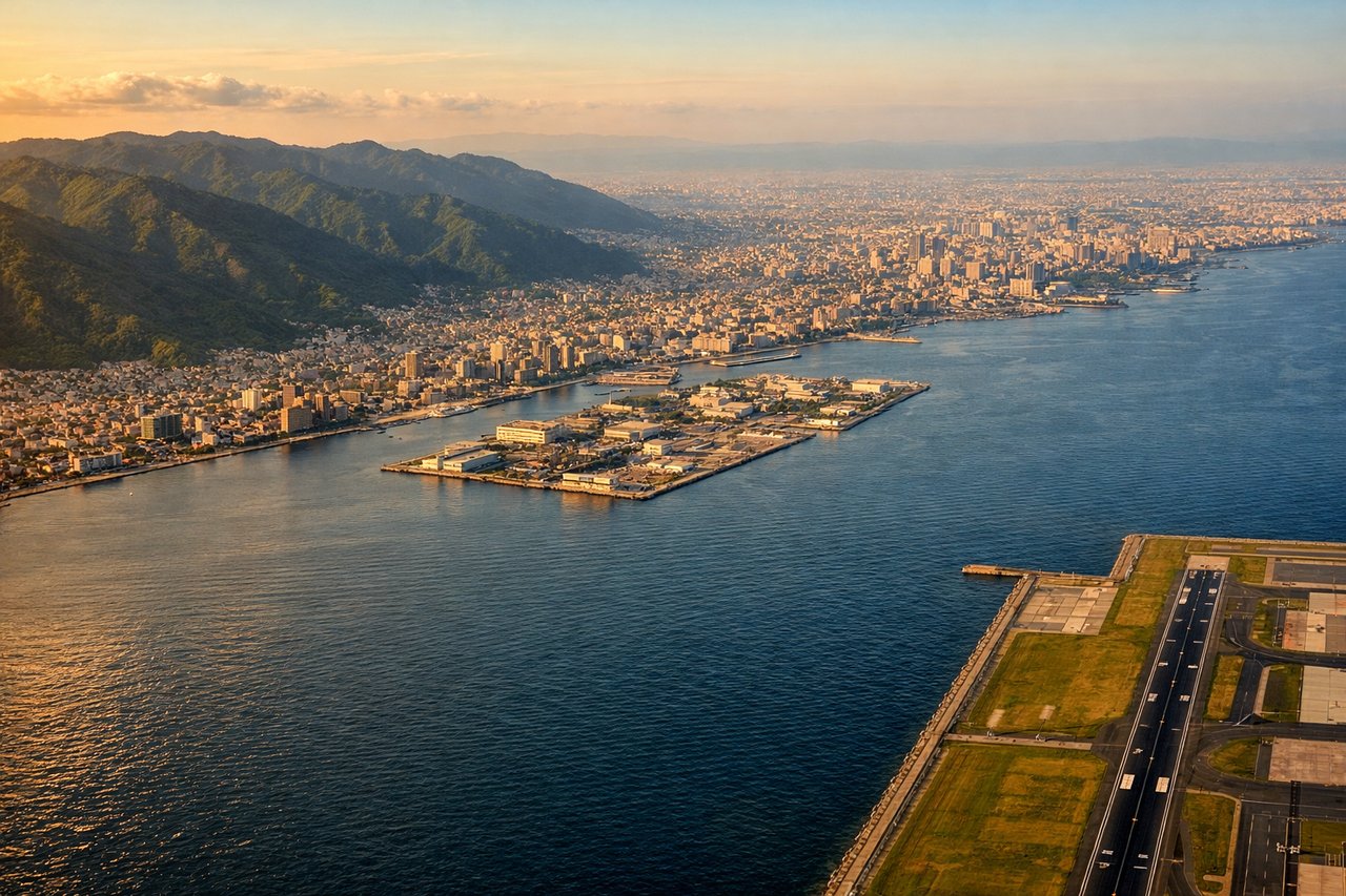
The left side wins both bookend phases of the flight — Manila Bay and the city skyline at takeoff, then Osaka Bay with the Osaka/Kobe skyline and Mount Rokko at landing — while the long mid-flight cruise over open ocean is scenically neutral for either side.
Flown MNL to KIX? Did we get it right?
Flight Path
Manila to Osaka is 1,637 miles (2,635 km), a flight of about 3 hours 55 minutes.
The route tracks northeast over the open Philippine Sea, passing well east of Taiwan and east of the main Ryukyu Islands (Okinawa chain), which may appear only as faint outlines far to the west; otherwise the cruise is dominated by featureless open ocean until the Kii Channel approach into Japan.
Great circle distance and headings ›Phase by phase
Takeoff from MNL
LEFTDeparting NAIA on runway 06 (or turning north after 24), the initial climb and left turn onto the Japan-bound course puts Manila Bay and the Metro Manila skyline on the left side, with Makati and Bonifacio Global City's towers visible against the water. The right side only shows Laguna de Bay and the low Sierra Madre foothills, which are less distinct from altitude.
Landing at KIX
LEFTOn a straight-in approach to KIX's runway 06 from the south, the aircraft descends over the Kii Channel and Osaka Bay before landing northeast toward the mainland. Looking left (northwest) during final approach reveals the Osaka skyline and Kobe backed by the Mount Rokko range, a striking urban-mountain combination. The right side mainly shows open water and the more distant Kii Peninsula coastline.
Will your flight be in sunlight?
Pick a date and time in the Sun Map to watch the sun move across your whole flight.
About This Route
Which side of the plane should I sit on flying from Ninoy Aquino International (MNL) to Kansai International (KIX)?
Sit on the Left side of the plane for the best views on flights from Manila to Osaka. The left side wins both bookend phases of the flight — Manila Bay and the city skyline at takeoff, then Osaka Bay with the Osaka/Kobe skyline and Mount Rokko at landing — while the long mid-flight cruise over open ocean is scenically neutral for either side.
What can I see during takeoff from Ninoy Aquino International in Manila?
During takeoff from Ninoy Aquino International (MNL), sit on the Left side for the best views. Departing NAIA on runway 06 (or turning north after 24), the initial climb and left turn onto the Japan-bound course puts Manila Bay and the Metro Manila skyline on the left side, with Makati and Bonifacio Global City's towers visible against the water. The right side only shows Laguna de Bay and the low Sierra Madre foothills, which are less distinct from altitude. Notable sights include: Manila Bay, Metro Manila skyline (Makati/BGC/Intramuros), Bataan Peninsula highlands across the bay.
What can I see when landing at Kansai International in Osaka?
When landing at Kansai International (KIX), sit on the Left side for the best views. On a straight-in approach to KIX's runway 06 from the south, the aircraft descends over the Kii Channel and Osaka Bay before landing northeast toward the mainland. Looking left (northwest) during final approach reveals the Osaka skyline and Kobe backed by the Mount Rokko range, a striking urban-mountain combination. The right side mainly shows open water and the more distant Kii Peninsula coastline. Notable sights include: Osaka Bay, Osaka city skyline, Kobe and Mount Rokko range, Awaji Island near the bay mouth.
How long is the flight from Manila to Osaka?
The flight from Ninoy Aquino International (MNL) to Kansai International (KIX) takes about 3 hours 55 minutes. The shortest flight path between them is 1,637 miles (2,635 km); winds and air traffic control usually add a few percent.
What does the Manila to Osaka flight path pass over?
The route tracks northeast over the open Philippine Sea, passing well east of Taiwan and east of the main Ryukyu Islands (Okinawa chain), which may appear only as faint outlines far to the west; otherwise the cruise is dominated by featureless open ocean until the Kii Channel approach into Japan.