Basse Terre to Philipsburg is 57 miles (91 km), a flight of about 25 minutes.
While the left side offers superior takeoff scenery with Saint Kitts' volcanic terrain, the right side's landing experience at SXM is genuinely extraordinary—the famous Maho Beach low-altitude approach is one of the Caribbean's most distinctive aviation experiences. The landing sequence significantly outweighs the takeoff advantage, and the cruise phase over open ocean is relatively featureless on both sides. Right side scores higher overall due to the iconic arrival.
Flight Path
Open Caribbean waters between Saint Kitts and Sint Maarten; no significant land features visible during cruise phase. The flight path crosses approximately 35 nautical miles of open ocean with no islands or major geographic features in the direct route.
Great circle distance and headings ›Phase by phase
Takeoff from SKB
LEFTLeft side captures the dramatic volcanic terrain of Saint Kitts immediately after departure. The island's central mountain range and lush green slopes dominate the initial climb-out, with the Caribbean Sea spreading westward. Right side shows mostly open ocean and the distant outline of Nevis.
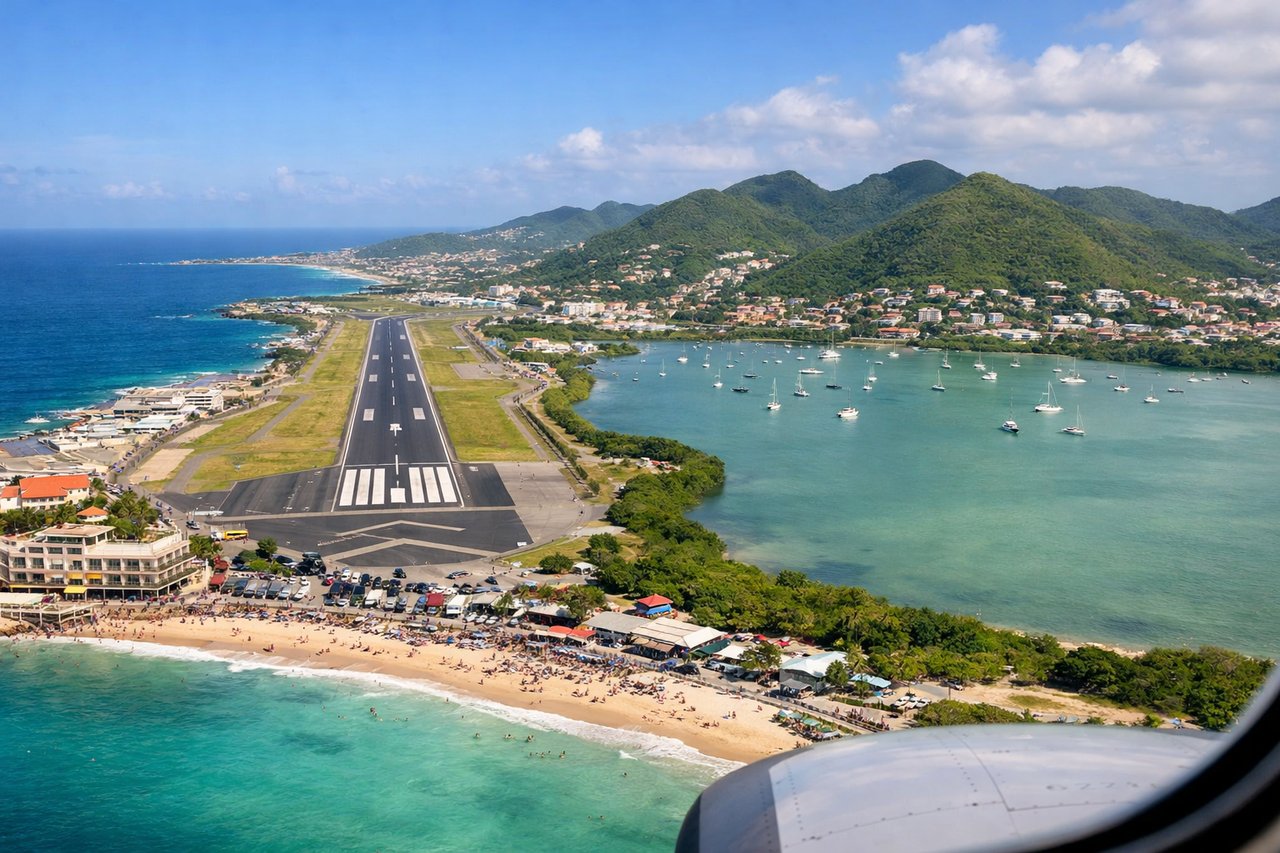
Landing at SXM
RIGHTRight side offers the iconic Maho Beach approach into SXM. Passengers descend directly over the beach and shallow turquoise waters at extremely low altitude (under 1,000 feet), with Sint Maarten's coastline, resort development, and the runway threshold in clear view. Left side shows open ocean and lacks the dramatic low-altitude coastal scenery.
Will your flight be in sunlight?
Pick a date and time in the Sun Map to watch the sun move across your whole flight.
About This Route
Which side of the plane should I sit on flying from Robert L Bradshaw (SKB) to Princess Juliana International (SXM)?
Sit on the Right side of the plane for the best views on flights from Basse Terre to Philipsburg. While the left side offers superior takeoff scenery with Saint Kitts' volcanic terrain, the right side's landing experience at SXM is genuinely extraordinary—the famous Maho Beach low-altitude approach is one of the Caribbean's most distinctive aviation experiences. The landing sequence significantly outweighs the takeoff advantage, and the cruise phase over open ocean is relatively featureless on both sides. Right side scores higher overall due to the iconic arrival.
What can I see during takeoff from Robert L Bradshaw in Basse Terre?
During takeoff from Robert L Bradshaw (SKB), sit on the Left side for the best views. Left side captures the dramatic volcanic terrain of Saint Kitts immediately after departure. The island's central mountain range and lush green slopes dominate the initial climb-out, with the Caribbean Sea spreading westward. Right side shows mostly open ocean and the distant outline of Nevis. Notable sights include: Mount Liamuiga (3,792 ft, Saint Kitts' volcanic peak), the narrow coastal plains around Basseterre, Nevis island in the distance to the south.
What can I see when landing at Princess Juliana International in Philipsburg?
When landing at Princess Juliana International (SXM), sit on the Right side for the best views. Right side offers the iconic Maho Beach approach into SXM. Passengers descend directly over the beach and shallow turquoise waters at extremely low altitude (under 1,000 feet), with Sint Maarten's coastline, resort development, and the runway threshold in clear view. Left side shows open ocean and lacks the dramatic low-altitude coastal scenery. Notable sights include: Maho Beach (the famous low-altitude approach corridor), Simpson Bay Lagoon, the Princess Juliana runway threshold, Sint Maarten's northern coastline with resort development.
How long is the flight from Basse Terre to Philipsburg?
The flight from Robert L Bradshaw (SKB) to Princess Juliana International (SXM) takes about 25 minutes. The shortest flight path between them is 57 miles (91 km); winds and air traffic control usually add a few percent.
What does the Basse Terre to Philipsburg flight path pass over?
Open Caribbean waters between Saint Kitts and Sint Maarten; no significant land features visible during cruise phase. The flight path crosses approximately 35 nautical miles of open ocean with no islands or major geographic features in the direct route.