Left seats provide the most dramatic scenery at both ends: North Shore Mountains during departure and Mauna Kea/volcanic terrain during approach. The takeoff view is particularly superior, making left the better choice for the full journey.
Flight Path
The flight path crosses the open Pacific Ocean for roughly 2,000 nautical miles. No significant landmarks are visible in the midpoint—only open ocean. Pilots typically cruise at 35,000-37,000 feet where curvature of Earth becomes subtly visible on clear days. Occasional weather systems and cloud formations provide the only visual variation. The transition from temperate Pacific waters near British Columbia to tropical Pacific waters occurs gradually with no visible boundary. On rare clear days at altitude, the faint outline of smaller Hawaiian islands (Maui, Oahu) may appear on the horizon during final descent phase, but these are not guaranteed sightings.
Great circle distance and headings ›

Phase by phase
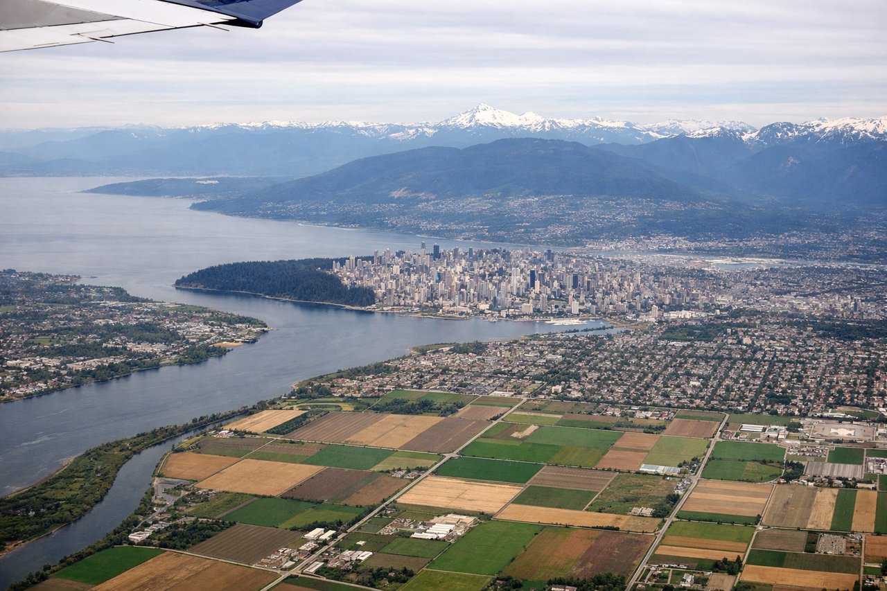
Takeoff from YVR
LEFTYVR typically departs runways 26L/26R (westbound) or 08L/08R (eastbound). For southbound departures to Hawaii, westbound runways are standard. Left seats capture the North Shore mountains and Strait of Georgia immediately after rotation, with views extending toward Vancouver Island.
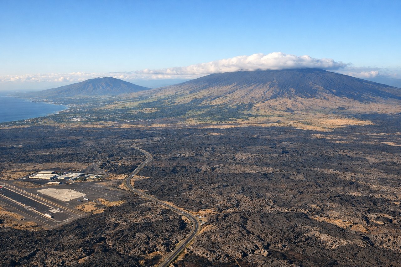
Landing at KOA
RIGHTApproach to KOA typically uses runway 17 (southbound) or 35 (northbound). The Big Island's volcanic terrain and Mauna Kea are positioned to the right during standard southbound approaches. Right-side seats offer clear views of the island's dramatic topography and the lava fields surrounding the airport.
Landmarks on this routeAll landmarks →
Will your flight be in sunlight?
See exactly which side of the plane gets sun and shade at your departure time.
About This Route
Which side of the plane should I sit on flying from Vancouver International (YVR) to Kona International At Keahole (KOA)?
Sit on the Left side of the plane for the best views on flights from Vancouver to Kona. Left seats provide the most dramatic scenery at both ends: North Shore Mountains during departure and Mauna Kea/volcanic terrain during approach. The takeoff view is particularly superior, making left the better choice for the full journey.
What can I see during takeoff from Vancouver International in Vancouver?
During takeoff from Vancouver International (YVR), sit on the Left side for the best views. YVR typically departs runways 26L/26R (westbound) or 08L/08R (eastbound). For southbound departures to Hawaii, westbound runways are standard. Left seats capture the North Shore mountains and Strait of Georgia immediately after rotation, with views extending toward Vancouver Island. Notable sights include: North Shore Mountains (Grouse, Seymour, Cypress peaks), Strait of Georgia, Vancouver Island coastline, Burrard Inlet.
What can I see when landing at Kona International At Keahole in Kona?
When landing at Kona International At Keahole (KOA), sit on the Right side for the best views. Approach to KOA typically uses runway 17 (southbound) or 35 (northbound). The Big Island's volcanic terrain and Mauna Kea are positioned to the right during standard southbound approaches. Right-side seats offer clear views of the island's dramatic topography and the lava fields surrounding the airport. Notable sights include: Mauna Kea (13,796 ft, often snow-capped), Kohala Mountains (northern tip), Kona lava fields, Kailua-Kona town.
How long is the flight from Vancouver to Kona?
The flight from Vancouver International (YVR) to Kona International At Keahole (KOA) takes Approximately 5 hours 15 minutes.
What does the Vancouver to Kona flight path pass over?
The flight path crosses the open Pacific Ocean for roughly 2,000 nautical miles. No significant landmarks are visible in the midpoint—only open ocean. Pilots typically cruise at 35,000-37,000 feet where curvature of Earth becomes subtly visible on clear days. Occasional weather systems and cloud formations provide the only visual variation. The transition from temperate Pacific waters near British Columbia to tropical Pacific waters occurs gradually with no visible boundary. On rare clear days at altitude, the faint outline of smaller Hawaiian islands (Maui, Oahu) may appear on the horizon during final descent phase, but these are not guaranteed sightings.